| WPC Met Watch |
|
|
Mesoscale Precipitation Discussion: #0202 |
|
(Issued at 937 PM EDT Tue Apr 30 2024
) |
|
| MPD Selection |
|
|
|
|
|

Mesoscale Precipitation Discussion 0202
NWS Weather Prediction Center College Park MD
937 PM EDT Tue Apr 30 2024

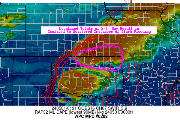
Areas affected...northeastern OK...southeastern KS

Concerning...Heavy rainfall...Flash flooding possible

Valid 010135Z - 010735Z

Summary...Localized totals of 2-4" may result in isolated to
scattered instances of flash flooding.

Discussion...A vigorous line of thunderstorms has organized
rapidly this evening across southeast KS, just ahead of a dry
line/cold front intersection with an associated low pressure
system located just to the north (near Topeka). In the area of
interest, the mesoscale environment is characterized by ML CAPE of
2000-3000 J/kg, PWATs of 1.1-1.3 inches (between the 75th and 90th
percentile, per SPC sounding climatology), and deep layer (0-6km)
shear of 30-40 kts. Strong southerly low-level moisture transport
is ongoing into the region, resulting in very high moisture flux
convergence and continued growth in the organizing convective
system.

As the front/dry line hang back to the west across central KS/OK,
this will allow for localized training as the (850-300 mb) mean
wind supports general storm movement towards the east (with
backbuilding being the main mechanism for training). The HRRR
depicted the potential for this localized training for many runs
this afternoon (but has backed off a bit on the idea closer to
00z), which was reflected in the HREF neighborhood probabilities
for 3" exceedance (as high as 20-30% through 06z). Although there
is not a lot of CAM support anything more than localized flash
flooding, the radar and satellite presentation have become quite
impressive and the trends support localized totals of 2-4"
developing. Idealized training of convection may result in
scattered instances of flash flooding.

Churchill

ATTN...WFO...ICT...OUN...SGF...TSA...

ATTN...RFC...ABRFC...NWC...

LAT...LON   37739580 37739543 37479472 36519467 36049502
            36349721 36559782 37009810 37389726 37539644
Download in GIS format: Shapefile
| KML
Last Updated: 939 PM EDT Tue Apr 30 2024
|


