


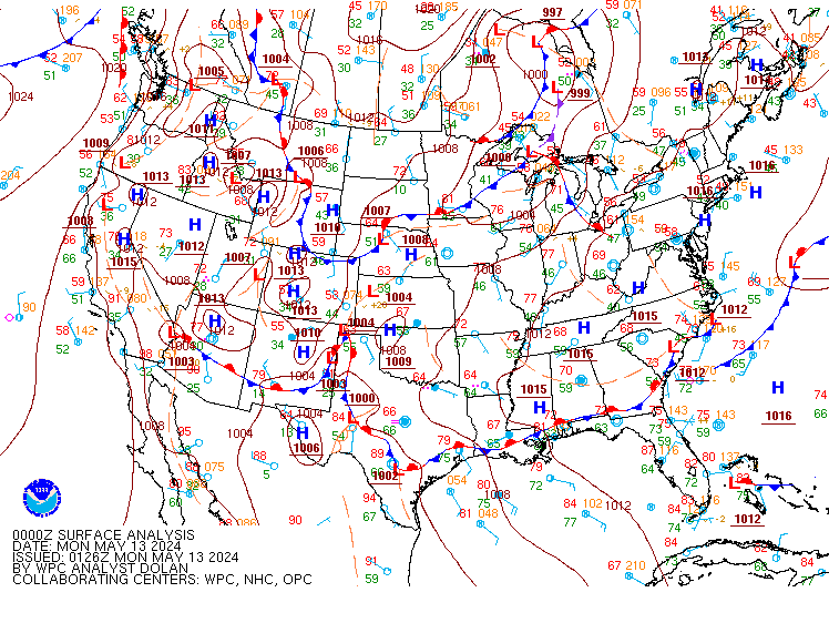
Valid Tue Apr 30, 2024
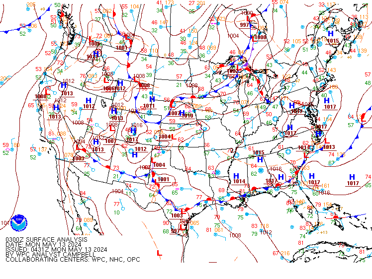
Valid Wed May 1, 2024
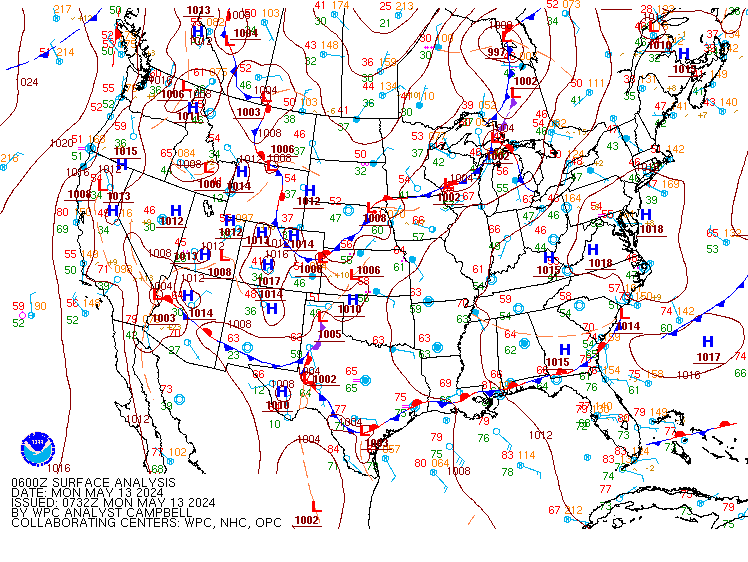
Valid Thu May 2, 2024

+ Additional Links
- » Description of the National Forecast Chart
- » Product Archives
- » Download hazards in KML or shapefile format or GeoJSON format


NWS Weather Prediction Center College Park MD
400 PM EDT Tue Apr 30 2024
Valid 00Z Wed May 01 2024 - 00Z Fri May 03 2024
...Severe Weather and Excessive Rainfall concerns for parts of the
Upper/Middle Mississippi Valley and Great Plains through mid-week...
...Moderate Risk of Excessive Rainfall now in place for the Ark-La-Tex
Thursday...
...Critical Fire Weather potential over portions of the Southern High
Plains on Wednesday...
...Cool and snowy in the Northwest; above average conditions continue
across much of the Central and Eastern U.S....
Mean ridging over the eastern U.S. with an energetic upper-level trough
over the north-central/northwestern U.S. will keep most of the active
weather over the next few days over portions of the Upper/Middle
Mississippi Valley and Great Plains. Showers and thunderstorms will
continue into Tuesday evening as an upper-level wave/surface frontal
system over the Central Plains moves to the northeast through the
Upper/Middle Mississippi Valley. There is an Enhanced Risk (level 3/5) of
severe weather from the Storm Prediction Center through Tuesday evening
from central Iowa southwestward through northeastern Kansas for the threat
of very large hail, damaging winds, and a few tornadoes. Additional storms
further to the southwest along a trailing cold front will lead to a risk
for some locally heavy rainfall totals as storm motions stall in tandem
with the slowing cold front. Some scattered instances of flash flooding
will be possible from southeastern Kansas into northern Oklahoma with a
Slight Risk of Excessive Rainfall (level 2/4) in place.
As this system departs to the into the Great Lakes, another upper-level
wave approaching from the west over the Rockies will help to
reinforce/organize the trailing frontal system over the Central High
Plains. This will bring yet another round of showers and thunderstorms
across the Plains Wednesday. Severe storms are expected ahead of a dryline
over portions of the Central/Southern Plains. A broad Slight Risk is in
place for very large hail, damaging winds, and tornadoes, with a localized
Enhanced Risk over southwest Kansas/northwestern Oklahoma. Dry, windy
conditions behind the dryline will also bring a heightened threat of
wildfires, with a Critical Risk of Fire Weather (level 2/3) issued by the
Storm Prediction Center for the Southern High Plains.
Storms are expected to cluster/expand in coverage into the evening hours
Wednesday as the frontal system lifts into the Middle Missouri Valley. A
southern stream upper-level wave will help lead to a second area of
enhanced convective development over portions of southern Oklahoma into
much of the eastern half of Texas. In both cases, plentiful moisture and a
strong low level jet will help foster locally intense rainfall, with
Slight Risks of Excessive Rainfall for the threat of scattered flash
flooding. Both areas of storms are forecast to continue into the day
Thursday with daytime heating bringing the potential for additional
development from the Upper-Mississippi Valley south-southwestward through
the Lower Missouri Valley and into the Ark-La-Tex. A broad Slight Risk of
Excessive Rainfall has been issued for the region, with a targeted
Moderate Risk (level 3/4) now in place for the Ark-La-Tex. Wet antecedent
conditions due to rainfall from any initial storms followed by the
prospects of additional development will continue the threat for flash
flooding.
Some showers and thunderstorms will remain possible along the East Coast
through Tuesday evening as a frontal system lingers over the Northeast
with a surface trough extending south through Florida. Some storms may
last into Wednesday and Thursday, particularly over New England in
vicinity of passing frontal systems. Unsettle conditions will continue for
the Pacific Northwest into portions of the northern Interior West through
mid-week as the upper-level trough remains in place over the region. Lower
elevations will see light to moderate showers with snow for the higher
elevations. Snow accumulations should remain relatively limited except for
portions of the northern Rockies of Montana where winter-weather related
advisories/warnings are in place. Temperature wise, conditions will tend
to be above average ahead of the trough over the central/eastern U.S. with
numerous highs in the 80s outside of the Northern Tier. Areas of the
Central Plains east through the Great Lakes will be in the 60s and 70s,
with 50s and 60s for the Northern Plains and New England. Conditions will
remain below average in the West, with mainly 50s and 60s for the Pacific
Northwest and the Interior West, 60s and 70s in central/southern
California, and warmer temperatures into the low 90s for the Desert
Southwest.
Putnam
Graphics available at
https://www.wpc.ncep.noaa.gov/basicwx/basicwx_ndfd.php
NWS Weather Prediction Center College Park MD
251 PM EDT Tue Apr 30 2024
Valid 12Z Fri May 03 2024 - 12Z Tue May 07 2024
19Z Update: The models remain in good overall synoptic scale
agreement for the end of this week, so a general deterministic
model blend works out well for Friday. This also holds true going
into Saturday, with some gradual timing differences with the trough
approaching the West Coast region. The GFS starts becoming more
amplified with the trough/closed low over California, and thus
leads to more enhanced precipitation across this region. More
substantial differences become apparent across the West going into
Sunday and beyond. The 00Z ECMWF was on the northern edge of the
guidance with the upper low across the Northern Rockies. The AIFS
from the ECMWF suggests a position farther south, more in line with
the CMC, but not to the degree of the GFS. Looking ahead to next
Tuesday, the CMC is stronger with the next trough approaching the
Pacific Northwest. The incorporation of the ensemble means
increased to about 40% for early next week, while still maintaining
some previous WPC continuity. The previous forecast discussion,
along with an updated ERO description, is appended below. /Hamrick
------------------
...Overview...
For late this week, lifting upper troughing and a couple of
surface cold fronts moving east by Friday should push rain chances
across the east-central and eastern U.S., but a subtropical jet and
the western side of the front stalling will lead to additional
threats for heavy rainfall in the south-central U.S. this weekend
as well. Meanwhile, the West is likely to see some precipitation
including some higher elevation snow during the period, but
confidence in the details is still lower than desired given ample
spread in the model guidance.
...Guidance/Predictability Assessment...
As the medium range period begins Friday, a consolidating upper
low should be located near the U.S./Canada border with a surface
low nearby over northern Minnesota or so, while upper ridging is
atop much of the East. Model guidance is within reasonable
agreement with these features though with some detail differences.
The bigger model diagnostics challenge is with an upper low
dropping southeast through the eastern Pacific coming toward the
West Coast this weekend. Deterministic models and ensemble
members/means and AI/machine learning (ML) models vary with the
positioning of this low. Even early in the medium range time frame,
GFS runs have persistently been on the southwestern side of the
spread, which then leads to the upper low farther south into
California and the Southwest as it translates east early next week.
Meanwhile, ECMWF runs do not dig the trough as far south, taking
it across the Northwest over the weekend and quickly into the
northern Plains. The 12Z EC ensemble mean was similarly shallow and
fast with the trough. The 12Z ML models were generally in between
these southwest and northeast extremes with the feature, though
there were some variations. The CMC and UKMET have been in between,
though the 12Z UKMET seemed to be a fast outlier. The incoming 00Z
models seem to keep the same sorts of biases as the 12/18Z cycle.
In going for a middle ground solution for the western low, which
seems the most realistic result, using a blend combining the
faster/shallower ECMWF with the slower/deeper GEFS mean (not quite
as slow/deep as the deterministic GFS runs) was favored for the WPC
model blend. With the preference for an intermediate solution, did
not favor the GFS-type QPF, so backed away from the
precipitation's southern extent into California and the central
Great Basin by combining the NBM with the ECMWF/CMC. The GFS/GEFS
mean/ensemble bias corrected solutions were farther south than
preferred.
...Weather/Hazards Highlights...
Scattered to widespread showers and thunderstorms are forecast
from the south-central U.S. northeastward into the Lower
Mississippi, Tennessee, and Ohio Valleys on Friday ahead of a
frontal boundary. While the threat for heavy rainfall to cause
flash flooding is lower than earlier in the week owing to waning
upper level support, a Marginal Risk remains in place for the Day
4/Friday ERO for nuisance level flooding issues in some areas. The
Marginal was expanded some to the southeast compared to the
overnight issuance owing to a slightly faster frontal progression.
By Saturday, the subtropical jet gets renewed across the Southern
Plains and more focused convection is becoming likely in a moist
and unstable environment. A Slight Risk area is now planned for
portions of southwest Oklahoma and into portions of northwest Texas
where a stronger model signal exists for an MCS with heavier
rainfall rates.
Many areas in the south-central U.S. will have quite saturated
antecedent conditions because of recent and upcoming short range
events, so this will be a factor for flooding as well. Additionally
on Saturday, an instability axis is likely to advect northward
across the southern/central Appalachians and into the Piedmont
between the synoptic cold front and backdoor front in the East as a
shortwave aloft moves through. Some heavy rain is likely for these
areas so a Marginal Risk for flash flooding remains valid. Showers
and thunderstorms should continue for portions of the central and
eastern U.S. on Sunday.
A round of light to moderate precipitation including higher
elevation snow in Wyoming to north-central Colorado is possible on
Friday. Then the Pacific upper low will provide support to spread
precipitation into the Northwest and steadily eastward into the
weekend and early next week. But the Pacific Northwest into the
northern Rockies should see lower elevation rain and higher
elevation snow, with precipitation reaching the northern Plains by
Monday. A Marginal Risk area is now planned from northwestern
California to western Washington for Day 4, and a Marginal Risk for
western portions of the Sierra on Day 5 (and snow for the Sierra
ridges).
Warmer than normal temperatures by 10-15 degrees are forecast for
the Ohio Valley to Great Lakes and Appalachians on Friday. Over the
weekend a backdoor front may cool the Mid-Atlantic to a few degrees
below normal for highs, while the east-central U.S. stays above
normal but less so than on Friday. Farther west, the northern
Rockies and Plains can expect cooler than normal temperatures
through late week, but the Intermountain West to that area should
warm up over the weekend to above normal. Warm temperatures should
spread across much of the eastern two-thirds of the country next
week. 90s are forecast to become more widespread across the
southern tier, with temperatures over 100F into southwest Texas. On
the other hand, the West Coast states are likely to see cooler than
normal temperatures early next week, but with the details uncertain
because of model spread with the trough aloft.
Tate/Hamrick
Additional 3-7 Day Hazard information can be found on the WPC
medium range hazards outlook chart at:
https://www.wpc.ncep.noaa.gov/threats/threats.php
WPC medium range 500mb heights, surface systems, weather grids,
quantitative precipitation forecast (QPF), excessive rainfall
outlook (ERO), winter weather outlook (WWO) probabilities, heat
indices, and Key Messages can be accessed from:
https://www.wpc.ncep.noaa.gov/medr/5dayfcst500_wbg.gif
https://www.wpc.ncep.noaa.gov/medr/5dayfcst_wbg_conus.gif
https://www.wpc.ncep.noaa.gov/5km_grids/5km_gridsbody.html
https://www.wpc.ncep.noaa.gov/qpf/day4-7.shtml
https://www.wpc.ncep.noaa.gov/#page=ero
https://www.wpc.ncep.noaa.gov/wwd/pwpf_d47/pwpf_medr.php?day=4
https://www.wpc.ncep.noaa.gov/heat_index.shtml
https://www.wpc.ncep.noaa.gov/#page=ovw
Hawaii Extended Forecast Discussion
NWS Weather Prediction Center College Park MD
338 AM EDT Tue Apr 30 2024
Valid 00Z Wed May 01 2024 - 00Z Wed May 08 2024
Generally east-southeast to east winds are present across Hawaii,
with the slight veering of the winds due to upper and surface lows
to the northwest of the state. Another day or so of winds staying
light to moderate over the eastern islands and weak enough over
the northwestern islands to allow for a hybrid trade and land/sea
breeze pattern can be expected. Some showers are possible but
should not be too widespread.
For midweek and beyond, surface highs developing well north of the
state and eventually consolidating will lead to gradually
increasing easterly trades, reaching moderate to breezy levels by
Friday and lasting into early next week. Meanwhile model guidance
is in fairly good agreement with showing a mid-upper trough/low
centered west of Hawaii late week and then coming overhead by
early next week. This should provide some instability for
increased showers, which would favor windward and mauka areas
given the increasing trades.
Tate


» Extreme Precipitation Monitor
+ Additional Links
- » Product Verification
- » Product Archive
- » Product Info
- » Additional formats of QPF: GRIB 2 | Shapefiles | KML
- » Other QPF Products

+ Forecast Discussion
Excessive Rainfall Discussion
NWS Weather Prediction Center College Park MD
419 PM EDT Tue Apr 30 2024
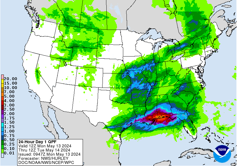
Day 1
Valid 16Z Tue Apr 30 2024 - 12Z Wed May 01 2024
...THERE IS A SLIGHT RISK OF EXCESSIVE RAINFALL FOR PORTIONS OF
SOUTHEAST KANSAS AND NORTHERN AND NORTHEASTERN OKLAHOMA...
...16Z Update...
Generally only minor tweaks were made to the inherited forecast.
The large scale pattern described in the previous discussion below
remains valid.
...Kansas and Oklahoma...
The primary change made in this area was to expand the inherited
Slight Risk area south to include much more of northern and
northeastern Oklahoma with this update. CAMs guidance is in good
agreement that convection that forms in Kansas and Oklahoma this
afternoon will congeal into an east-west oriented line of storms
largely on the Oklahoma side of the border this evening, persisting
well into the overnight hours. The line itself may be nearly
stationary for a few hours before slowly weakening and dissipating
in the predawn hours Wednesday. There remains considerable
uncertainty, as is typical, with exactly where the line of storms
forms and how quickly it moves to the south, so the inherited
Slight in Kansas was left largely intact, though the flash flooding
threat there has diminished somewhat. Northern and northeastern
Oklahoma was hit hard in recent days with multiple inches of rain
from strong storms, so this area also has elevated river levels and
reduced FFGs, making it more vulnerable to flash flooding.
The storms are likely to focus in a relatively small area that in
a north-south sense should only cover a row or 2 of counties. Both
the expected small size of the highest risk area and inherent
uncertainty with the ultimate behavior of the expected convection
precluded any consideration of a further upgrade. However, should
the storms impact the hardest hit areas, locally significant and
considerable flooding could occur.
...South Florida...
A Marginal risk area was introduced for portions of south Florida.
Afternoon convection is expected to form in southwest Florida this
afternoon as PWATs spike above 1.5 inches in weak steering flow. A
frontal system is approaching the state's Gulf Coast now, and when
added to the moisture-rich atmosphere in place across the state,
slow-moving storms are likely to develop, then gradually shift east
towards the I-95 corridor. Conditions have been drier than normal
across much of the Florida Peninsula lately, which should help
preclude any widespread flash flooding, but slow moving storms in a
moisture-abundant atmosphere have the potential to produce rates
that may locally exceed FFGs. For this reason, a low-end Marginal
was needed.
...New York and Pennsylvania...
The Marginal Risk area in the Northeast was trimmed out of the
Hudson Valley with this update. Afternoon convection is likely to
form on the west side of the Catskills. As the storms grow upscale,
they will encounter a faster steering flow in the upper levels,
which will help accelerate them eastward. So while rates may exceed
FFGs, the time at which those rates will be realized will decrease
with time. Thus, the Marginal remains for the portions of NY and PA
that are most likely to see the storms initially forming, before
they move too fast to be much of a flash flooding threat.
...Elsewhere...
For South Texas and the upper Midwest, no significant changes were
made, see the previous discussion below for more details in these
areas.
Wegman
...Previous Discussion...
...Kansas and Oklahoma...
A surface cyclone will develop over the northern plains with a cold
front extending along the southern periphery of the surface
reflection. A strong southerly component downstream of the surface
low will allow for a pool of elevated theta-E's to advect poleward
into eastern KS and Oklahoma during the late afternoon time frame
with an associated increase in regional instability within the axis
of higher theta-E's. There is a growing consensus for convective
initiation across east-central KS towards the 23-01z period where
the LLJ kicks and the aforementioned cold front converges on the
region with rapid CI likely somewhere north of Wichita. A moisture
rich environment thanks to low-level moisture advection coupled
with primed instability in-of the area will lead to locally heavy
rain within any convective development, especially under more
prominent supercellular modes thanks to increasing shear within the
area of positive buoyancy. 00z HREF blended mean QPF has really
become bullish with totals approaching 2.5-3" now across that area
in and north of Wichita with some guidance expanding further as
cold pool propagation to the south would expand some pretty hefty
totals to areas that were just recently impacted. Rates are likely
to approaching 2-3"/hr based on the latest HREF probability fields
(30-40%) which would easily eclipse the lower FFG indices in place
after the recent deluge. The area near the KS/OK border is
conditional to the cold pool propagation and the cold front
expecting to struggle to gain latitude leading to an elongated
front where convection can situate through the end of the period.
Some models are aggressive with totals exceeding 3" if that were to
occur, so the prospects for higher end impact lead to the addition
of a SLGT risk over the area where the threat is maximized.
...Northeast...
A stalled frontal boundary is analyzed across northern NJ,
extending west through northern PA, southern NY, into Ontario. A
cold front is currently moving through the Great Lakes in response
to surface low moving through the northern Midwest. The stationary
front, cold front, and attendant mid-level energy will all aid in
convective development this afternoon with initiation over western
NY and northern PA, moving eastward through peak diurnal
instability. Consensus for scattered thunderstorms has grown across
all guidance leading into the period with the latest CAMs
persistent on an axis of locally heavy rainfall impacting areas
from the Finger Lakes, eastward into the Hudson Valley. 00z HREF
blended mean QPF footprint depicts a large swath of 1-1.5" precip
totals in-of NY state with the northern fringes of PA out near
Bradford and Susquehanna also within the mean QPF swath formed via
the convective regime expected. Hourly rates will be the primary
driver for localized flooding across the area in question with
HREF probabilities for 1"/hr now topping out at 50-60% from a line
extending between Utica down to northeastern PA with the time frame
between 18-00z as the period of interest for convective initiation
and impact. 2"/hr rates are non-zero, but limited in spatial
coverage with probabilities peaking closer to 10-15% over portions
of southern NY state. The area of interest will lie along the
stalled front where the best low-level convergence axis will
reside, as well as where the favored mid-level vorticity maxima
advects overhead. Where these two align will likely lead to totals
approaching 2" within a course of 1.5-2 hrs before convection
steadily moves eastward. Areas with more urbanization will be
subject to the best flash flood potential due to runoff, as well as
areas that can pick up a quick 1.5-2" when impacted. The MRGL risk
was maintained from the previous forecast with some minor
adjustments on the fringes.
...Midwest to Upper Mississippi Valley...
A quick-moving shortwave will eject out of the southern periphery
of a negatively tilted longwave trough over the northern Plains
and southern Canada leading to convective genesis over the northern
and central plains. The latest HREF and associated CAMs highlight
the potential within the mean QPF forecast with a swath of 1-1.5"
possible over portions of MN/IA/Northwest WI with a signal for
local 2-3" amounts given the potpourri of deterministic. There is
less consensus on exactly where the stronger cells will reside, but
the initiation point across southeastern SD and eastern NE is
fairly consistent on guidance. The threat is low to mid-tier for
the MRGL risk, but probabilistic signals for at least 1"/hr and up
to a quick 2-3" are enough for some local impacts to areas who have
substantially lower FFG indices thanks to the previous series of
storms. The MRGL risk was maintained with little deviation from the
previous forecast.
...Southern Plains...
A dryline will focus over west TX into OK during the afternoon
today with scattered convection likely to fire after 20z within the
Stockton Plateau and portions of north TX towards the Red River.
Precip rates will be capped between 1-1.5"/hr which is enough for
some localized flood concerns in small towns with urbanization
factors that could enhance runoff potential. The threat is on the
lower end of MRGL, but resides within the scope of the threshold of
5%.
Kleebauer
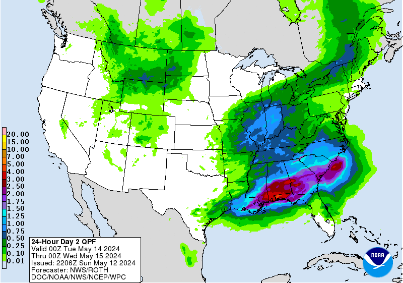
Excessive Rainfall Discussion
NWS Weather Prediction Center College Park MD
419 PM EDT Tue Apr 30 2024
Day 2
Valid 12Z Wed May 01 2024 - 12Z Thu May 02 2024
...THERE IS A SLIGHT RISK OF EXCESSIVE RAINFALL OVER PORTIONS OF
THE CENTRAL PLAINS AND SOUTHERN PLAINS...
...2030Z Update...
The main change from the inherited ERO for Wednesday and Wednesday
night was to split the inherited Slight risk into 2 separate
Slights, one in the central Plains following the Missouri River
between Nebraska and Iowa, and a second for southwest Oklahoma and
much of northern and eastern Texas.
With the benefit of CAMs guidance, all of the models that go out to
the end of the period 12Z Thu indicate that the overnight
convection Wednesday night will primarily be in the form of two
simultaneous but otherwise completely separate squall lines that
will both move eastward, one across Nebraska into Iowa, and a
second across north Texas. The guidance is in good agreement that
there may be an isolated shower or storm in between, but otherwise
the area in between is largely dry. Thus, due to a local minimum in
the guidance over Oklahoma/Kansas with good agreement in the CAMs
as to the same, the inherited Slight was split into 2 separate
smaller Slights. Despite very wet antecedent conditions expected in
KS/OK, especially after tonight/Day 1, the very isolated nature of
any additional convection Wednesday suggests the threat is
marginal.
For both Slights, antecedent conditions will also play a big role
in the development of any new flash flooding. The squall lines
responsible for the rain in both areas are likely to be moving at
a fairly rapid clip. In Texas, cell mergers with newly forming
showers and storms ahead of the line will locally produce added
rainfall, whereas such a scenario is not expected for the northern
Slight. Since fast moving squall lines have a very difficult time
on their own with causing new flash flooding, the antecedent wet
conditions in these areas will have to make up the difference.
Wegman
...Previous Discussion...
...Midwest/Central Plains...
A broad, closed upper level cyclone will persist over eastern MT
into the adjacent northern plains and southern Canadian Provinces
by Wednesday with a potent, mid-level shortwave rounding the base
of the mean trough and exiting into the northern high plains by the
second half of the period. A vigorous upper diffluent pattern will
transpire by Wednesday afternoon and evening with a corridor of
convection initiating towards nightfall. A stout LLJ will enhance
areal shear in-of the central and northern plains within the Quad
state area between NE/KS/IA/MO. Any convective development will
congeal and grow upscale into a large cluster of heavy
thunderstorms within the above area leading to widespread heavy
rains capable of flash flooding as rates likely reach towards that
1-2"/hr marker with locally higher possible. The one factor that
may limit the higher end potential will be the progressive nature
of the convection as pattern yields faster storm motions limiting
the prospects for training. This does not mean there will not be
some areas that can overachieve and maximize the potential based on
the prime mid-level energy involved, along with a strong meridional
push of some very moist air approaching 2-2.5 deviations above
normal for PWATs based on the latest GEFS and NAEFS output. The
threat remains solidly within the SLGT with a chance at any upgrade
if future CAMs indicate a better potential for totals to exceed 3"
in a larger footprint than what is currently depicted.
...Southern Plains...
The location on a secondary rainfall maximum across TX is becoming more
clear as a quick moving shortwave embedded within the subtropical jet
ejects out of MX and moves to the northeast by Wednesday evening. Guidance
suggests that somewhere across eastern TX would be the primary target
for convective development with the heaviest rainfall located within
the tongue of higher theta-E's positioned east of the line from ABI
to DRT. A cluster of thunderstorms will develop over west TX with a
steady propagation to the east during the afternoon and early
evening hours. By nightfall, a prominent LLJ aligned across
central and east TX will provide necessary maintenance to any
convective clusters that will migrate over the state after peak
diurnal instability. Surface dew points running into the upper-60s
and low-70s relay the moisture rich environment that will provide
the foundation for significant rainfall potential as the mid-level
vorticity maxima continues to move over the region providing the
additional large scale forcing that will keep the convection
rolling through the evening. Current deterministic output is
consistent with local totals breaching 4" across portions of
central and north TX with the latest ensemble bias corrected QPF
sufficiently in the range of 2-3" over an area extending from
southwest OK down through the DFW metroplex and adjacent surrounds.
This is quickly gaining steam for a higher impact event,
especially when you compound the idea that the northern portion of
the I-35 corridor in TX becomes a focal point. There is some spread
on the exact positioning of the heaviest precip expected, but ML
outputs have been persistent in the area over north TX for the past
succession of runs. Should deterministic guidance converge further
with similar amounts, or if ensemble support becomes more
aggressive with totals and probabilities for exceeding higher end
QPF markers, a Moderate Risk cannot be ruled out in later
issuance's. Moderate Risk impacts are certainly possible wherever
the heavy rainfall materializes with the highest prospects within
the major urban centers along I-35.
Kleebauer
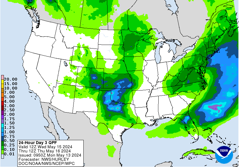
Excessive Rainfall Discussion
NWS Weather Prediction Center College Park MD
419 PM EDT Tue Apr 30 2024
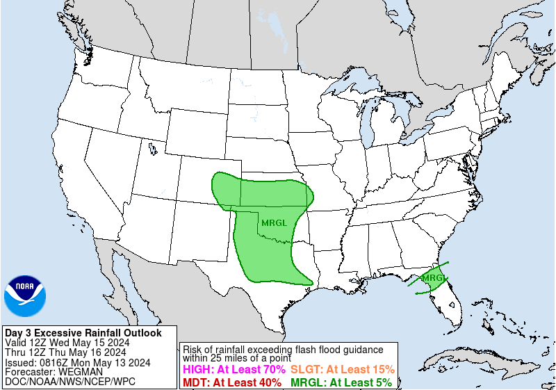
Day 3
Valid 12Z Thu May 02 2024 - 12Z Fri May 03 2024
...THERE IS A MODERATE RISK OF EXCESSIVE RAINFALL FOR PORTIONS OF
NORTHEAST TEXAS AND NORTHWEST LOUISIANA...
...2030Z Update...
...Texas/Louisiana...
12Z guidance remains in good agreement for a local maximum of
rainfall as high as 5 inches, with locally higher amounts in the
most persistent storms into portions of northeast Texas and
northwest Louisiana. While there are understandable differences in
the guidance as to the exact placement of the rain and certainly
how much...agreement remains good both in the current cycle of
guidance as a trends from the previous that this area will be hit
with storms producing multiple inches of rain, likely during the
daylight hours Thursday. This area has been hard hit in recent
days, resulting in saturated soils and very high river levels, with
a few draining south towards the Gulf still in major flood stage.
As such, additional multiple inches of rainfall should almost all
convert to runoff, likely resulting in scattered instances of flash
flooding, several of which will be locally
significant/considerable.
As mentioned, while there are some differences in the placement of
the heaviest rainfall, the unusually high level of agreement on the
broader area and magnitude of the impending rainfall event when
added to the ongoing flooding in the area increased the confidence
that the area of greatest overlap in northeast TX and northwest LA
of Moderate Risk level impacts. As always when dealing with
convection, once the event moves into the CAMs time frame it's
likely there will be changes in the placement and magnitude of the
heaviest rainfall. The area will continue to be monitored.
...Elsewhere...
Very few changes were needed for the Slight up into the Midwest, as
there remains much greater uncertainty as to the convective
evolution Thursday in this region. Much of this area is at or above
average for soil moisture given recent (and ongoing) heavy rains,
so reduced FFGs as far north as Wisconsin would support renewed
flash flooding with any persistent storms.
Wegman
...Previous Discussion...
...Summary: Two distinct areas of interest will arise for heavy
rainfall on D3 as a strong mid-level shortwave continues to march
eastward out of TX into the Lower Mississippi Valley by the middle
of the period. Further north, a powerful, negatively tilted trough
will maintain foothold across the northern plains with a strong
vorticity maxima pivoting around the southern periphery of the
closed upper reflection in place across southern Saskatchewan. Each
upper forcing will play a role in locally heavy rainfall impacts
spreading eastward from the continuation of the previous period.
The primary threat is currently front loaded with the best flood
prospects leaning towards Thursday morning and afternoon before the
threat wanes heading into the second half of the forecast period.
...Midwest...
Overnight convection from Wednesday will continue to march eastward
as the congealed cold pools from the initial cell mergers will
advance through the central Midwest with sights on eastern IA into
WI and MN on Thursday morning. The complex will eventually peter
out as it moves northward into a less favorable environment which
will put an end to the flooding threat as we move into the
afternoon. Later in afternoon and evening, a cold front will
propagate to the east out of the central plains with a
redevelopment of convection over eastern KS, IA, and northwest MO.
This will allow for the secondary peak of flash flooding potential
as thunderstorms migrate through the mid and upper Mississippi
Valley, impacting some areas that were just affected in the last 24
hrs. With the lower FFGs expected, the threshold for flooding will
be much lower than climatological norms for some areas within the
expected secondary convective regime. Totals are currently within
the 1-3" range on guidance which is significant enough to warrant
at least the current SLGT risk in place with some chance at further
upgrades pending prior period(s) evolution and precip outcomes.
...Southern Plains and Lower Mississippi Valley...
A fairly significant complex of thunderstorms will likely be
ongoing in the beginning of the period with the cold pool
propagation forecast to impact areas of east TX into Louisiana,
similar areas that were just hit recently with significant rainfall
and flash flooding. The prospects for flooding are now well above
climatological norm as areal FFG indices are solidly 50% of what
they normally are during the time of year (2-3" compared to 4-5").
Forecast QPF is hovering between 2-4" with locally higher with the
ensemble bias corrected forecast showing a wide swath of 2+" and
some deterministic already ramping up over 5" across east TX into
north-central LA. Considering the repeated nature of these heavy
rain threats, the prospects for flooding is growing with a SLGT
risk in place over the Arklatex down into parts of east TX and the
Lower Mississippi Valley. Pending the forecast from the previous
period with CAM guidance assistance, an upgrade to a Moderate Risk
may very well be entertained.
Further north across KS and OK, the cold front to the north will
move south with a push from high pressure nosing in through the
plains in wake of the low pressure moving to the north. An area of
convection will likely form over the central plains and move south
with the boundary leading to more locally heavy rainfall in
association with the area of convection. The threat is less
aggressive compared to what is expected further south, but the
chances are still prevalent. The SLGT risk was maintained from the
previous D4 connecting the two primary areas of interest to the
north and south.
Kleebauer
NWS Weather Prediction Center College Park MD
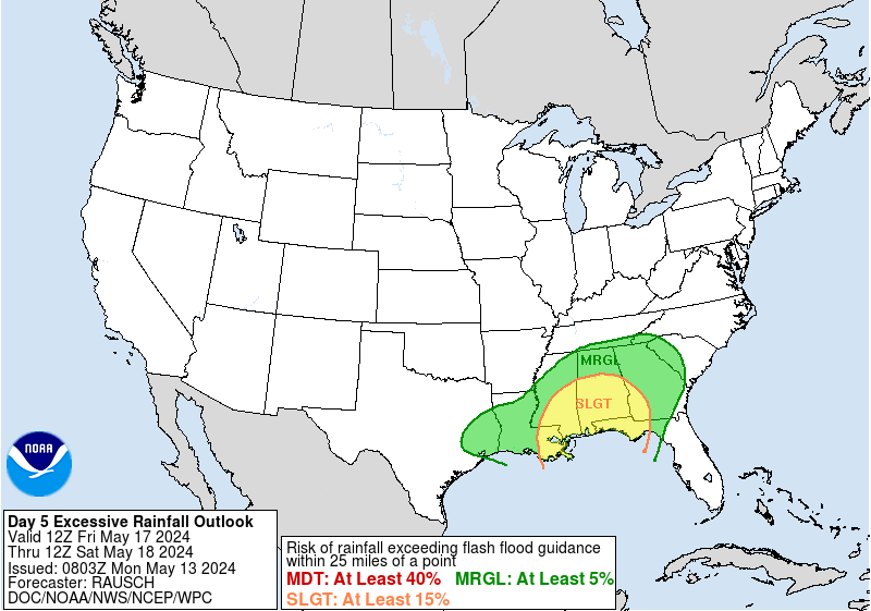
251 PM EDT Tue Apr 30 2024
Scattered to widespread showers and thunderstorms are forecast
from the south-central U.S. northeastward into the Lower
Mississippi, Tennessee, and Ohio Valleys on Friday ahead of a
frontal boundary. While the threat for heavy rainfall to cause
flash flooding is lower than earlier in the week owing to waning
upper level support, a Marginal Risk remains in place for the Day
4/Friday ERO for nuisance level flooding issues in some areas. The
Marginal was expanded some to the southeast compared to the
overnight issuance owing to a slightly faster frontal progression.
By Saturday, the subtropical jet gets renewed across the Southern
Plains and more focused convection is becoming likely in a moist
and unstable environment. A Slight Risk area is now planned for
portions of southwest Oklahoma and into portions of northwest Texas
where a stronger model signal exists for an MCS with heavier
rainfall rates.
Many areas in the south-central U.S. will have quite saturated
antecedent conditions because of recent and upcoming short range
events, so this will be a factor for flooding as well. Additionally
on Saturday, an instability axis is likely to advect northward
across the southern/central Appalachians and into the Piedmont
between the synoptic cold front and backdoor front in the East as a
shortwave aloft moves through. Some heavy rain is likely for these
areas so a Marginal Risk for flash flooding remains valid. Showers
and thunderstorms should continue for portions of the central and
eastern U.S. on Sunday.
A round of light to moderate precipitation including higher
elevation snow in Wyoming to north-central Colorado is possible on
Friday. Then the Pacific upper low will provide support to spread
precipitation into the Northwest and steadily eastward into the
weekend and early next week. But the Pacific Northwest into the
northern Rockies should see lower elevation rain and higher
elevation snow, with precipitation reaching the northern Plains by
Monday. A Marginal Risk area is now planned from northwestern
California to western Washington for Day 4, and a Marginal Risk for
western portions of the Sierra on Day 5 (and snow for the Sierra
ridges).
Warmer than normal temperatures by 10-15 degrees are forecast for
the Ohio Valley to Great Lakes and Appalachians on Friday. Over the
weekend a backdoor front may cool the Mid-Atlantic to a few degrees
below normal for highs, while the east-central U.S. stays above
normal but less so than on Friday. Farther west, the northern
Rockies and Plains can expect cooler than normal temperatures
through late week, but the Intermountain West to that area should
warm up over the weekend to above normal. Warm temperatures should
spread across much of the eastern two-thirds of the country next
week. 90s are forecast to become more widespread across the
southern tier, with temperatures over 100F into southwest Texas. On
the other hand, the West Coast states are likely to see cooler than
normal temperatures early next week, but with the details uncertain
because of model spread with the trough aloft.
Tate/Hamrick
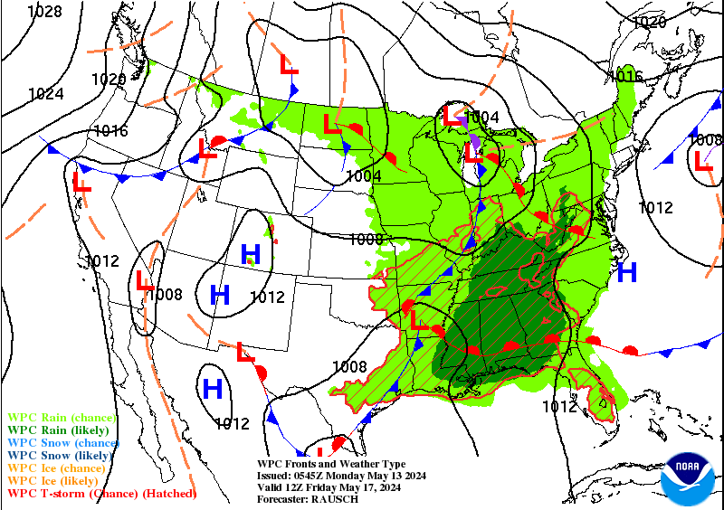
NWS Weather Prediction Center College Park MD
251 PM EDT Tue Apr 30 2024
Scattered to widespread showers and thunderstorms are forecast
from the south-central U.S. northeastward into the Lower
Mississippi, Tennessee, and Ohio Valleys on Friday ahead of a
frontal boundary. While the threat for heavy rainfall to cause
flash flooding is lower than earlier in the week owing to waning
upper level support, a Marginal Risk remains in place for the Day
4/Friday ERO for nuisance level flooding issues in some areas. The
Marginal was expanded some to the southeast compared to the
overnight issuance owing to a slightly faster frontal progression.
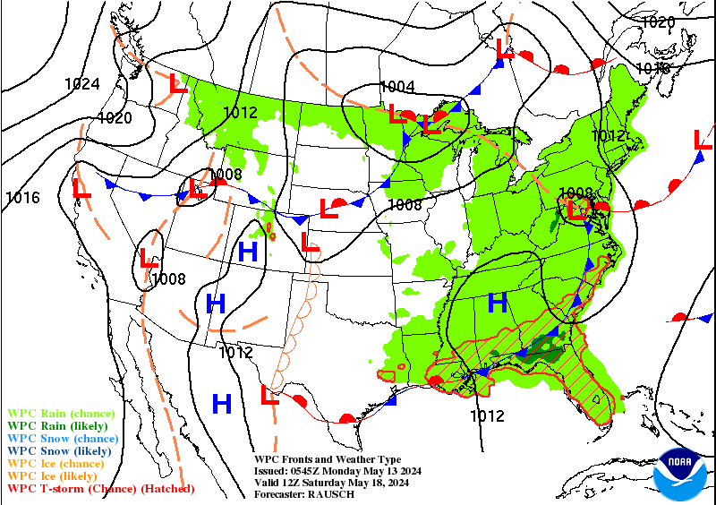
By Saturday, the subtropical jet gets renewed across the Southern
Plains and more focused convection is becoming likely in a moist
and unstable environment. A Slight Risk area is now planned for
portions of southwest Oklahoma and into portions of northwest Texas
where a stronger model signal exists for an MCS with heavier
rainfall rates.
Many areas in the south-central U.S. will have quite saturated
antecedent conditions because of recent and upcoming short range
events, so this will be a factor for flooding as well. Additionally
on Saturday, an instability axis is likely to advect northward
across the southern/central Appalachians and into the Piedmont
between the synoptic cold front and backdoor front in the East as a
shortwave aloft moves through. Some heavy rain is likely for these
areas so a Marginal Risk for flash flooding remains valid. Showers
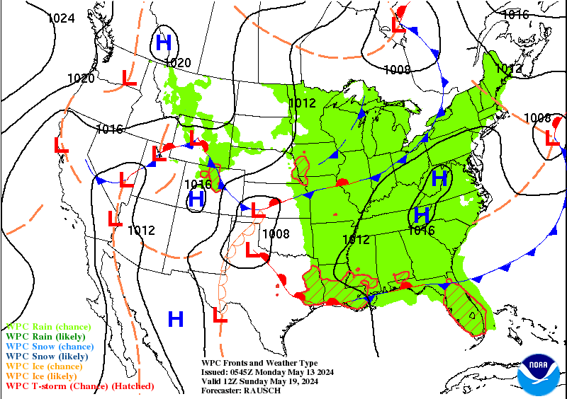
and thunderstorms should continue for portions of the central and
eastern U.S. on Sunday.
A round of light to moderate precipitation including higher
elevation snow in Wyoming to north-central Colorado is possible on
Friday. Then the Pacific upper low will provide support to spread
precipitation into the Northwest and steadily eastward into the
weekend and early next week. But the Pacific Northwest into the
northern Rockies should see lower elevation rain and higher
elevation snow, with precipitation reaching the northern Plains by
Monday. A Marginal Risk area is now planned from northwestern
California to western Washington for Day 4, and a Marginal Risk for
western portions of the Sierra on Day 5 (and snow for the Sierra
ridges).
Warmer than normal temperatures by 10-15 degrees are forecast for
the Ohio Valley to Great Lakes and Appalachians on Friday. Over the
weekend a backdoor front may cool the Mid-Atlantic to a few degrees
below normal for highs, while the east-central U.S. stays above
normal but less so than on Friday. Farther west, the northern
Rockies and Plains can expect cooler than normal temperatures
through late week, but the Intermountain West to that area should
warm up over the weekend to above normal. Warm temperatures should
spread across much of the eastern two-thirds of the country next
week. 90s are forecast to become more widespread across the
southern tier, with temperatures over 100F into southwest Texas. On
the other hand, the West Coast states are likely to see cooler than
normal temperatures early next week, but with the details uncertain
because of model spread with the trough aloft.
Tate/Hamrick


» Interactive Winter Weather Map (Day 4-7)
» Winter Storm Severity Index
+ Forecast Discussion (Day 1-3)
Probabilistic Heavy Snow and Icing Discussion
NWS Weather Prediction Center College Park MD
317 PM EDT Tue Apr 30 2024
Valid 00Z Wed May 01 2024 - 00Z Sat May 04 2024
...Pacific Northwest and Northern Rockies...
Days 1-2...
A large upper low over the northwestern U.S. and southwest Canada
will inject a steady stream of Pacific moisture and positive
vorticity advection over the Pacific Northwest and Northern Rockies
through tonight. Lift will be maximized aloft thanks to the
divergent left-exit region overhead through tonight while mean
850-300mb wind flow out of the west will support upslope
enhancement
in the Oregon Cascades, the Sawtooth, Tetons, and Absaroka. By
Wednesday morning, low pressure over southern Alberta will pivot
southward and shift low level winds out of the N-NE. This, in
addition to the pivoting deformation axis of precipitation
advancing southward throughout the day, will lead to upslope
enhancement on the eastern slopes of the Lewis Range (including
Glacier NPS) through Thursday. Cyclonic flow on the western
periphery of the low will also result in upslope snowfall
enhancement in mountain ranges such as the Absaroka, Tetons, Little
Belt, Big Snowy, and other neighboring mountain tops of at least
6,000ft in elevation. Snow will finally come to an end by Thursday
night as high pressure builds in from southwest Canada.
For the duration of this snow event, WPC PWPF shows high chances
(>70%) for snowfall amounts >12" in the Little Belt Mountains and
along the Lewis Range with moderate-to-high chances for >18"
(including Glacier NPS). Mountain ranges with moderate-to-high
chances for >8" of snowfall include portions of the Oregon
Cascades, the Absaroka, Tetons, and tallest peaks of the Big
Horns. The WSSI depicts mostly Minor Impacts in these mountain
ranges with the Lewis Range, given their higher probabilities for
>12" snowfall totals, most likely to witness Moderate Impacts
through Thursday.
...Central Rockies...
Days 2-3...
By Wednesday afternoon, low pressure forming in lee of the Central
Rockies and positive vorticity advection out ahead of a longwave
trough centered over the Great Basin will utilize a sliver of
Pacific moisture aloft to generate a ribbon of precipitation from
the Colorado Rockies to the Nebraska Panhandle. Further enhancing
the strong vertical ascent aloft is the region's placement beneath
the diffluent right-entrance region of a 250mb jet streak which
combined with falling freezing levels will allow for precipitation
to fall in the form of snow in the Colorado Rockies and both the
Medicine Bow and Park Ranges of southern Wyoming. Snow will fall
heaviest between 21Z Wed - 09Z Thursday and quickly conclude by
early Thursday morning as the area of low pressure in lee of the
Central Rockies races east into the Central Plains. As is the case
this time of year, the heaviest totals will be confined to the
highest elevations, particularly above 9,000ft. WPC PWPF shows low
chances (10-30%) for snowfall amounts >8", but it does show
moderate-to-high chances (50-70%) for >4" of snowfall. Overall,
impacts will generally top out on the minor-side (some winter
driving conditions, use caution while driving) as depicted by the
WSSI-P which shows low chances (10-30%) for Minor Impacts late
Wednesday and through early Thursday morning. Attention then
shifts
to a fast moving upper level disturbance that will produce
additional mountain snow in similar mountains ranges and elevations
Friday morning and into Friday afternoon. WPC PWPF continues to
show low chances (10-30%) for snowfall totals >8", and the WSSI-P
shows low chances (10-30%) of Minor Impacts along the Front Range
of the Central Rockies through Friday afternoon.
The probability of significant icing is less than 10 percent.
Mullinax
- » Experimental Winter Storm Outlook
- » Probabilistic Winter Storm Severity Index
- » Product Verification
- » Product Archive
- » Product Info
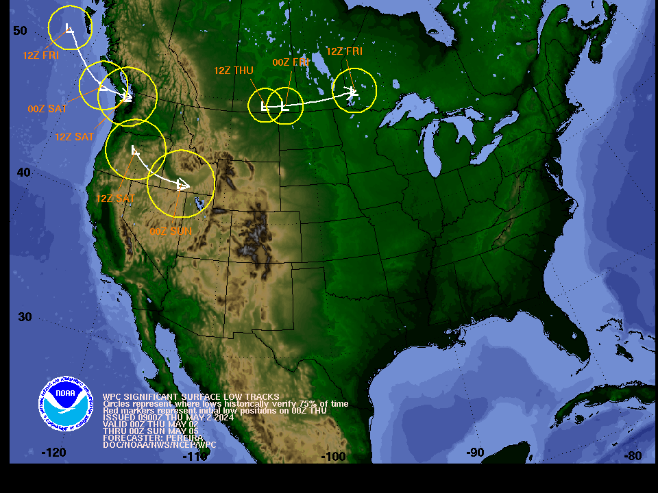
- » Forecast Surface Low Positions: Uncertainty Circles | Ensemble Clusters
- » Other Winter Weather Products
NWS Weather Prediction Center College Park MD
251 PM EDT Tue Apr 30 2024
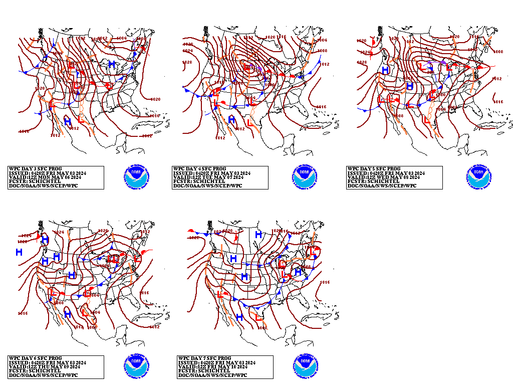
Valid 12Z Fri May 03 2024 - 12Z Tue May 07 2024
19Z Update: The models remain in good overall synoptic scale
agreement for the end of this week, so a general deterministic
model blend works out well for Friday. This also holds true going
into Saturday, with some gradual timing differences with the trough
approaching the West Coast region. The GFS starts becoming more
amplified with the trough/closed low over California, and thus
leads to more enhanced precipitation across this region. More
substantial differences become apparent across the West going into
Sunday and beyond. The 00Z ECMWF was on the northern edge of the
guidance with the upper low across the Northern Rockies. The AIFS
from the ECMWF suggests a position farther south, more in line with
the CMC, but not to the degree of the GFS. Looking ahead to next
Tuesday, the CMC is stronger with the next trough approaching the
Pacific Northwest. The incorporation of the ensemble means
increased to about 40% for early next week, while still maintaining
some previous WPC continuity. The previous forecast discussion,
along with an updated ERO description, is appended below. /Hamrick
------------------
...Overview...
For late this week, lifting upper troughing and a couple of
surface cold fronts moving east by Friday should push rain chances
across the east-central and eastern U.S., but a subtropical jet and
the western side of the front stalling will lead to additional
threats for heavy rainfall in the south-central U.S. this weekend
as well. Meanwhile, the West is likely to see some precipitation
including some higher elevation snow during the period, but
confidence in the details is still lower than desired given ample
spread in the model guidance.
...Guidance/Predictability Assessment...
As the medium range period begins Friday, a consolidating upper
low should be located near the U.S./Canada border with a surface
low nearby over northern Minnesota or so, while upper ridging is
atop much of the East. Model guidance is within reasonable
agreement with these features though with some detail differences.
The bigger model diagnostics challenge is with an upper low
dropping southeast through the eastern Pacific coming toward the
West Coast this weekend. Deterministic models and ensemble
members/means and AI/machine learning (ML) models vary with the
positioning of this low. Even early in the medium range time frame,
GFS runs have persistently been on the southwestern side of the
spread, which then leads to the upper low farther south into
California and the Southwest as it translates east early next week.
Meanwhile, ECMWF runs do not dig the trough as far south, taking
it across the Northwest over the weekend and quickly into the
northern Plains. The 12Z EC ensemble mean was similarly shallow and
fast with the trough. The 12Z ML models were generally in between
these southwest and northeast extremes with the feature, though
there were some variations. The CMC and UKMET have been in between,
though the 12Z UKMET seemed to be a fast outlier. The incoming 00Z
models seem to keep the same sorts of biases as the 12/18Z cycle.
In going for a middle ground solution for the western low, which
seems the most realistic result, using a blend combining the
faster/shallower ECMWF with the slower/deeper GEFS mean (not quite
as slow/deep as the deterministic GFS runs) was favored for the WPC
model blend. With the preference for an intermediate solution, did
not favor the GFS-type QPF, so backed away from the
precipitation's southern extent into California and the central
Great Basin by combining the NBM with the ECMWF/CMC. The GFS/GEFS
mean/ensemble bias corrected solutions were farther south than
preferred.
...Weather/Hazards Highlights...
Scattered to widespread showers and thunderstorms are forecast
from the south-central U.S. northeastward into the Lower
Mississippi, Tennessee, and Ohio Valleys on Friday ahead of a
frontal boundary. While the threat for heavy rainfall to cause
flash flooding is lower than earlier in the week owing to waning
upper level support, a Marginal Risk remains in place for the Day
4/Friday ERO for nuisance level flooding issues in some areas. The
Marginal was expanded some to the southeast compared to the
overnight issuance owing to a slightly faster frontal progression.
By Saturday, the subtropical jet gets renewed across the Southern
Plains and more focused convection is becoming likely in a moist
and unstable environment. A Slight Risk area is now planned for
portions of southwest Oklahoma and into portions of northwest Texas
where a stronger model signal exists for an MCS with heavier
rainfall rates.
Many areas in the south-central U.S. will have quite saturated
antecedent conditions because of recent and upcoming short range
events, so this will be a factor for flooding as well. Additionally
on Saturday, an instability axis is likely to advect northward
across the southern/central Appalachians and into the Piedmont
between the synoptic cold front and backdoor front in the East as a
shortwave aloft moves through. Some heavy rain is likely for these
areas so a Marginal Risk for flash flooding remains valid. Showers
and thunderstorms should continue for portions of the central and
eastern U.S. on Sunday.
A round of light to moderate precipitation including higher
elevation snow in Wyoming to north-central Colorado is possible on
Friday. Then the Pacific upper low will provide support to spread
precipitation into the Northwest and steadily eastward into the
weekend and early next week. But the Pacific Northwest into the
northern Rockies should see lower elevation rain and higher
elevation snow, with precipitation reaching the northern Plains by
Monday. A Marginal Risk area is now planned from northwestern
California to western Washington for Day 4, and a Marginal Risk for
western portions of the Sierra on Day 5 (and snow for the Sierra
ridges).
Warmer than normal temperatures by 10-15 degrees are forecast for
the Ohio Valley to Great Lakes and Appalachians on Friday. Over the
weekend a backdoor front may cool the Mid-Atlantic to a few degrees
below normal for highs, while the east-central U.S. stays above
normal but less so than on Friday. Farther west, the northern
Rockies and Plains can expect cooler than normal temperatures
through late week, but the Intermountain West to that area should
warm up over the weekend to above normal. Warm temperatures should
spread across much of the eastern two-thirds of the country next
week. 90s are forecast to become more widespread across the
southern tier, with temperatures over 100F into southwest Texas. On
the other hand, the West Coast states are likely to see cooler than
normal temperatures early next week, but with the details uncertain
because of model spread with the trough aloft.
Tate/Hamrick
Additional 3-7 Day Hazard information can be found on the WPC
medium range hazards outlook chart at:
https://www.wpc.ncep.noaa.gov/threats/threats.php
WPC medium range 500mb heights, surface systems, weather grids,
quantitative precipitation forecast (QPF), excessive rainfall
outlook (ERO), winter weather outlook (WWO) probabilities, heat
indices, and Key Messages can be accessed from:
https://www.wpc.ncep.noaa.gov/medr/5dayfcst500_wbg.gif
https://www.wpc.ncep.noaa.gov/medr/5dayfcst_wbg_conus.gif
https://www.wpc.ncep.noaa.gov/5km_grids/5km_gridsbody.html
https://www.wpc.ncep.noaa.gov/qpf/day4-7.shtml
https://www.wpc.ncep.noaa.gov/#page=ero
https://www.wpc.ncep.noaa.gov/wwd/pwpf_d47/pwpf_medr.php?day=4
https://www.wpc.ncep.noaa.gov/heat_index.shtml
https://www.wpc.ncep.noaa.gov/#page=ovw
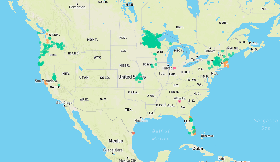
Displays flood and flash flood reports as well as intense rainfall observations for user-selectable time ranges and customizable geographic regions. Includes ability to download reports and associated metadata in csv format.
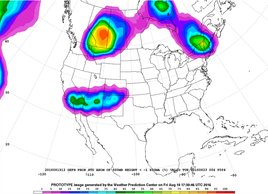
Plots of GEFS probabilistic forecast of precipitation, temperature, and sea-level pressure exceeding various thresholds.
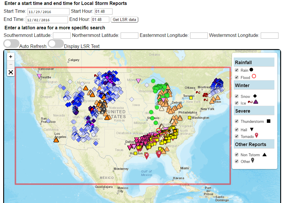
Custom plots of Local Storm Reports across the Contiguous United States. Reports include rain, snow, ice, and severe weather, as well as other significant information from storm spotters.
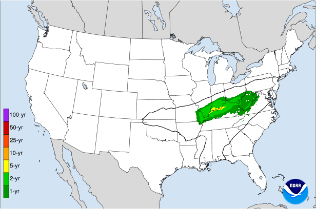
Displays the climatological significance of precipitation forecast by WPC. The climatological significance is represented by Average Recurrence Intervals (ARIs) of precipitation estimates from NOAA Atlas-14 and Atlas2.
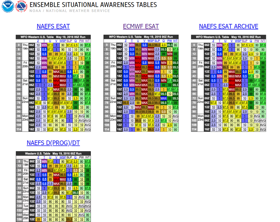
An interactive situational awareness table that displays anomalies, percentiles, and return intervals from the GEFS, NAEFS, and ECMWF Ensembles (login required to view ECMWF data).
*Please note that there is currently an issue where only users on a NOAA network can access this page. We are actively working to resolve this problem.
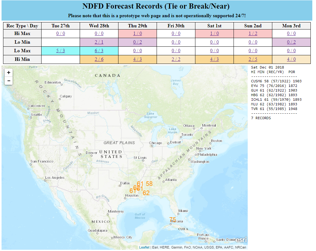
Interactive display of where temperatures could approach or exceed records within the contiguous U.S. (based on NDFD temperature forecasts)
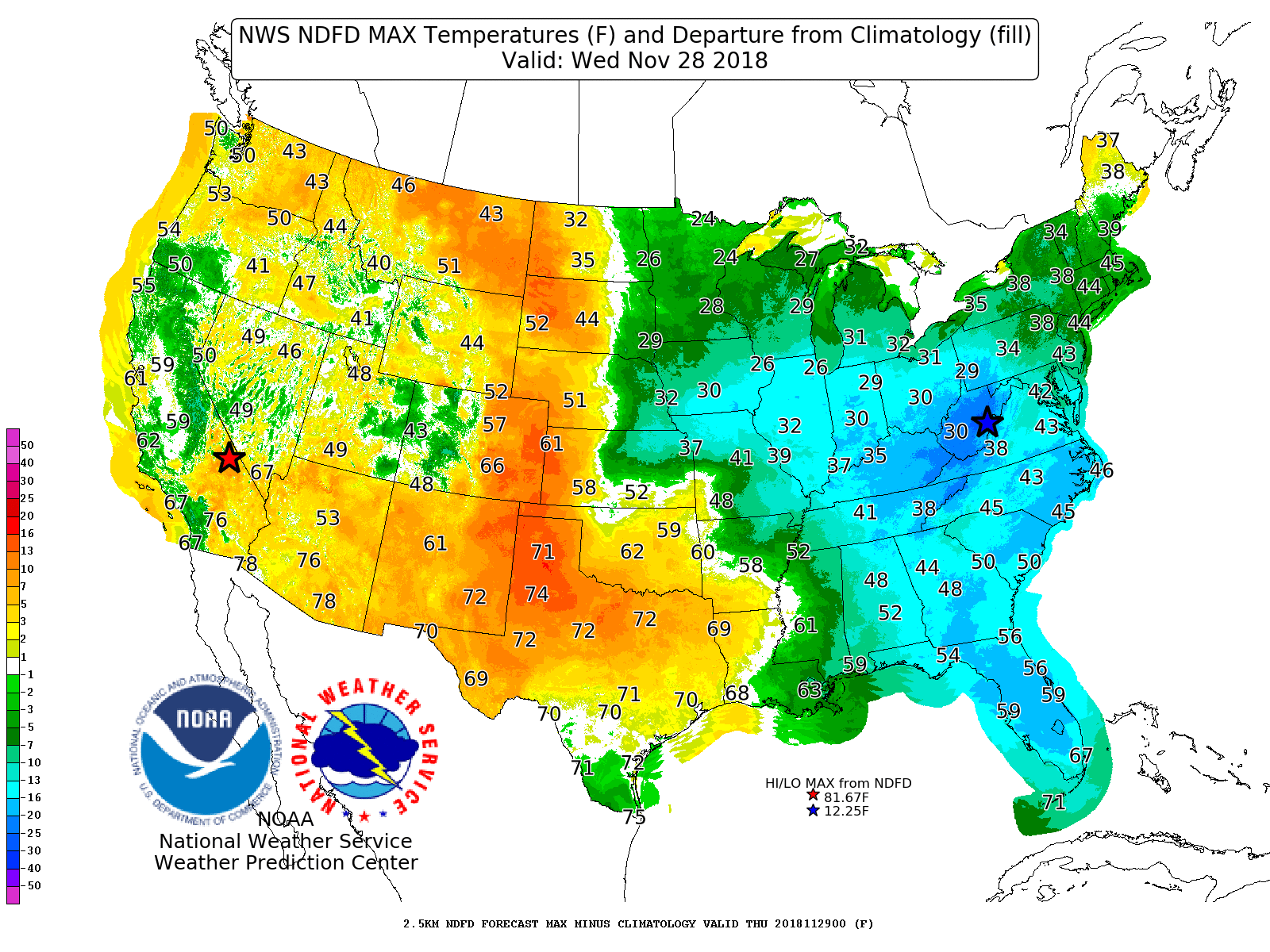
Displays Days 1-7 NDFD maximum and minimum temperatures, along with their respective departures from climatology.
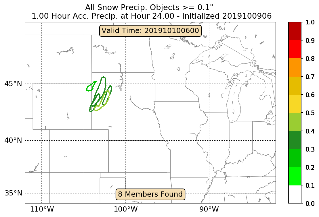
An interactive tool that depicts areas of heavy snowfall from individual members of high-resolution short range ensemble forecasts.
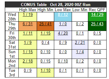
Displays forecast information and its climatological context to quickly alert a forecaster when a record or neear-record breaking event is possible. This tool is available for both CONUS and Alaska.
Interface for specialized WPC Excessive Rainfall Outlook Maps for NWS County Warning Areas and States.
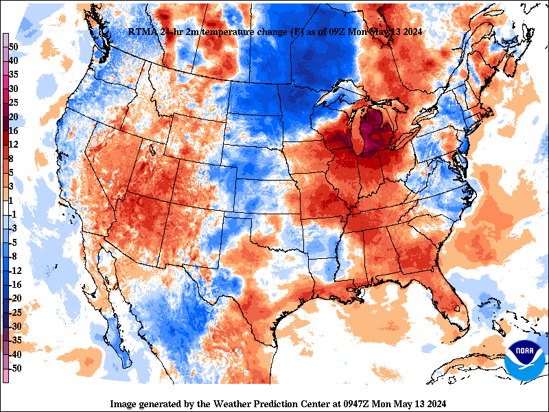
Change in weather parameters (temperature, dewpoint, surface pressure, etc) over the last 1/3/6/24 hours. Data is provided from the Real-Time Mesoscale Analysis (RTMA) or the Rapid Refresh (RAP).

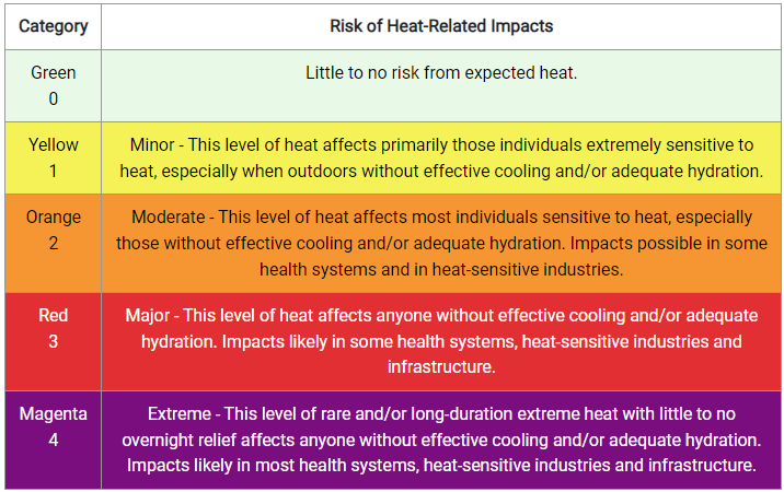
The experimental National Weather Service (NWS) HeatRisk is a color-numeric-based index that provides a forecast of the potential level of risk for heat-related impacts to occur over a 24-hour period, with forecasts available out through 7 days.
Analog guidance that uses an objective approach to find historical events that are similar to the upcoming forecast.
Nationally consistent and skillful suite of calibrated forecast guidance based on a blend of both NWS and non-NWS numerical weather prediction model data and post-processed model guidance.
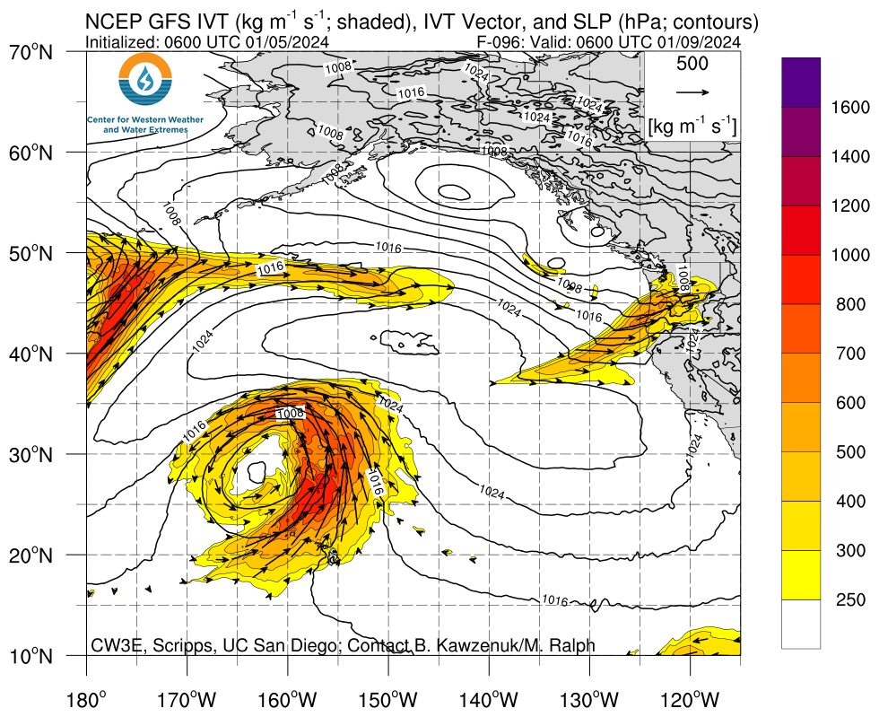
A portal for atmospheric river forecasts and diagnostics from the Center for Western Weather and Water Extremes.
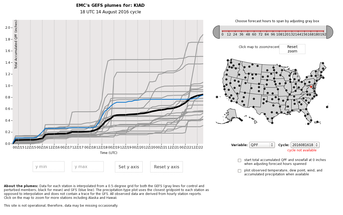
An interactive display of time series plots from GEFS ensemble members at a point.
A variety of useful tools generated at The Storm Prediction Center (SPC).
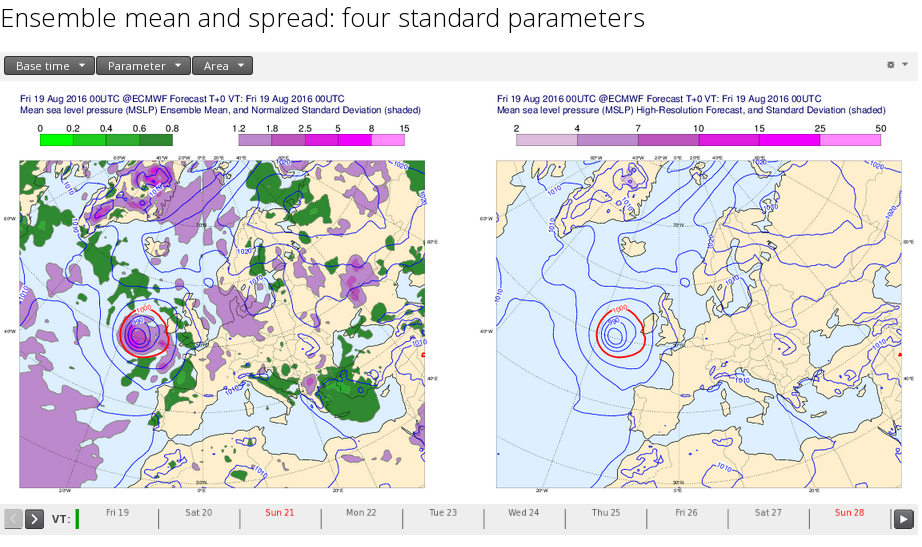
Output from the ECMWF 'Ensemble Prediction System' (ENS) for four parameters: mean sea level pressure, 850 hPa temperature, 850 hPa wind speed, and 500 hPa geopotential height.


