Excessive Rainfall Discussion
NWS Weather Prediction Center College Park MD
1146 AM EDT Tue Jul 14 2026
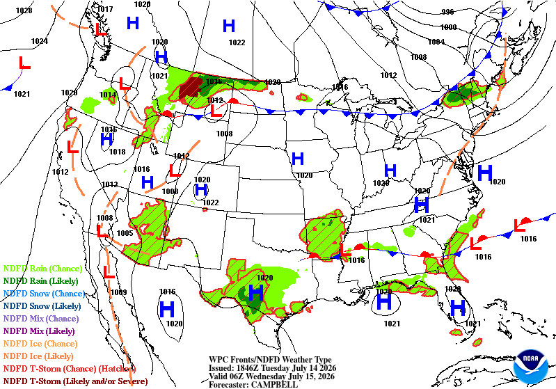
Day 1
Valid 16Z Tue Jul 14 2026 - 12Z Wed Jul 15 2026
...THERE IS A HIGH RISK OF EXCESSIVE RAINFALL IN THE TEXAS HILL
COUNTRY...
...Texas Hill Country...
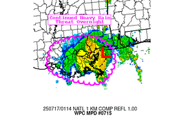
Portions of the TX Hill Country witnessed torrential rainfall last
night and this morning that will continue to unfold through
midday. Radar estimates show anywhere for 6-10" of rain have fallen
in Medina, Uvalde, and Bandera counties (locally around 12") and
have already led to reports of numerous flooded roadways and water
rescues. Looking ahead, the atmosphere is primed for additional
rounds of Excessive Rainfall with hourly rates between 2-4" likely.
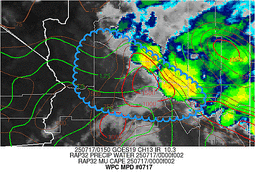
The 12Z RAOB out of Del Rio, TX showed an abundance of moisture
aloft (2.28" PW, well above the 90th climatological percentile) and
sufficient instability for thunderstorms to work with (~1,600 J/kg
of MLCAPE). The MCV north of Del Rio is the catalyst for this
event, tapping into the rich moisture and unstable air-mass to
generate numerous showers and thunderstorms. Overnight CAMs
struggled with the placement and duration of the storms this
morning, although new 12Z guidance is catching on better and is in
largely good agreement that storms will continue through early
afternoon. Many new 12Z CAMs suggest a brief lull may occur this
afternoon, but the presence of the MCV is likely to keep some
storms in the heart of TX through early evening.
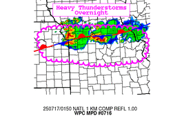
By tonight, the LLJ over South TX will strengthen and act to re-
supply additional low-level moisture towards the MCV, which is
forecast to hover near Del Rio, TX. The combination of upscale
ascent supported by the MCV, the LLJ intersecting a nearby stalled
frontal boundary, and natural topographic upslope into the Hill
Country west of I-35 will reinvigorate thunderstorm activity
tonight. It is worth noting that all CAMs do have an axis of
Excessive Rainfall with amounts in the 2-4" range overnight (locally
higher than 6"), but they disagree on placement. The 12Z HREF and
06Z REFS are keying in on areas closer to the MCV, essentially from
Medina/Bandera counties on WNW towards Del Rio with moderate
chances (40-60%) for additional rainfall totals >3" and low
chances (10-30%) for rainfall >5" between 00-12Z. Some members,
such as the 12Z HRRR and 12Z RRFS, show the axis of heavy rainfall
encroaching upon the western San Antonio suburbs. Given the
rainfall that the current atmospheric environment has already
produced, additional rainfall totals of 3-6" are forecast for the
remainder of today and through tonight in the TX Hill Country with
localized amounts over 10" possible. Reminder that this discussion
strictly focuses on 16Z today through 12Z Wednesday (Day 1), so
this does not take into account the rainfall still to come for Day
2 and the second half of the week.
In collaboration with the NWS San Antonio/Austin office, given the
likelihood for additional significant rainfall in areas slammed
with heavy rainfall and ongoing flooding this morning, a High Risk
was introduced for the 16Z update. Significant to locally
catastrophic flash flooding is forecast to continue today and, with
additional heavy rainfall tonight, likely to persist into tonight
and early morning Wednesday. Potential impacts include
flooded/impassable roads, flooded creeks/streams, and potential
inundation of homes. Please have a reliable means of receiving
weather warnings and information from local/state officials.
Elsewhere, some minor tweaks to the inherited Moderate and Slight
Risks were made to account for latest 12Z guidance, but otherwise
the setup featuring a pooling of anomalous moisture along a stalled
frontal boundary will continue to trigger additional strong storms
and scattered areas of flash flooding through this evening.
...Coastal South Carolina...
A Slight Risk was introduced along the South Carolina coast with
this update. The 12Z CHS sounding measured a 2.26" PW (above the
90th climatological percentile), MLCAPE over 1,000 J/kg, and a warm
cloud layer over 14,000ft deep. Storms have already flared up along
a frontal boundary both over land and at sea, and as daytime
heating ensues, additional strong thunderstorms are likely to
develop. Storms will be generally slow moving and can produce 3"/hr
rainfall rates with locally more intense, shorter bursts of
torrential rainfall possible. The 12Z HREF shows low-to-moderate
chances (20-50%) for localized areas of the SC coast receiving over
5" this afternoon. The area has dealt with locally heavy rainfall
in recent days and is a little more susceptible to rates
approaching 3"/hr, particularly in the more urbanized communities.
Mullinax
---Previous Discussion---
...Southeast into Southern Mid Atlantic...
General consensus on widespread convective development across the
southern Carolina's into the Southeast lends to at least a broad
MRGL risk for flash flooding in any area north of I-4 with a
relative max for heavy rain situated across portions of MS/AL
thanks to the presence of a meandering upper level disturbance over
the area. WV satellite this evening pin-points a weak upper level
circulation centered over northern MS with an extremely slow
propagation to the west-southwest over the past several hours. This
particular upper circulation will be a focal point for enhanced low
to mid-level convergence later this afternoon interacting with what
is a formidable moist/unstable environment across the Southeast
CONUS. Scattered to widespread showers and thunderstorms will
materialize across northern LA over into MS and AL during peak
diurnal destabilization leading to pulse/multi-cell convective
development over the region with heavy rain prospects likely very
high considering the environment in place. Wetbulb zero heights
>14k ft on forecast soundings across MS/AL indicate an effective
warm cloud layer that will likely present efficient rainfall rates
with even pulse variety convection yielding 2-3"/hr rainfall
potential during its mature phases. Slow cell motions under a weak
steering pattern situated across the Southeast will only act as an
aid to flash flood prospects over the region as cells will be more
likely to produce heavy bouts of rain for multiple hours before
drifting away from an area, or even just decaying overhead. 00z
HREF and REFS neighborhood probabilities for >3" are solidly
between 50-80% across central and south-central MS into western AL
with the main area of interest lying along and north of I-20 in
both areas. HREF blended mean outputs show a scattered 2-3" precip
signal over the aforementioned area with individual deterministic
even pushing close to 5" in the hardest hit locales. This is more
than sufficient for maintaining the previous SLGT risk forecast, as
well as wording for a high-end SLGT threshold likely over that area
encompassed within central MS to western AL.
...Southwest U.S. into the Great Basin...
Continued impacts expected from lying into the western flank of
the ridge centered over the Northern U.S. as prevailing southerly
flow will just maintain a prevalent moisture advection regime
poleward over the Desert Southwest into the Great Basin. Models
remain consistent in their interpretations of locally heavy
rainfall over both regions with the heaviest QPF centered over AZ,
but potentially greater impacts in those more flash flood prone
areas located in the interior west, including those slot canyons
over UT/NV. Rainfall rates will be the driving factor for flash
flooding in this scenario with instability generally favorable
(>750 J/kg MUCAPE) over a large portion of the Western CONUS. The
combination of PWAT anomalies >2 deviations above normal and
elevated instability favors at least widely scattered flash flood
potential, which this setup is leaning into the textbook signature
as forecast. 00z HREF neighborhood probabilities for >1" have a
smattering of 40-60% probs within areas of the Great Basin and
Four Corners with a more widespread 40-70% probability oriented in
the terrain from southeastern AZ up through the Mogollon Rim into
the area of the Grand Canyon. Any of these cells in the terrain
will be conducive for heavy rainfall between 0.5-1"/hr, locally
higher across the terrain with more of the general 0.25-0.75"/hr
over the Great Basin. Given the consistency in the model output and
anomalous moisture presence across the West, the previous MRGL
risk was maintained.
...Montana...
PWATs encroaching the 90-99th percentile over much of MT coupled
with favorable instability and approaching mid- level troughing to
the west will allow for scattered to perhaps widespread convection
to materialize over the Northern Rockies into Central MT later this
afternoon and evening. Ample shear and elevated moisture presence
will amplify the convective threat and proceeding heavy rainfall
posture across portions of Big Sky country as we move into the time
frame of peak diurnal destabilization. Organized cell clusters,
including a few supercells, are likely to initiate over the terrain
in the Central portion of MT with an eventual rapid storm motion
off to the northeast as the steering flow will allow for very quick
propagation(s) through the High Plains of MT by later in the
evening. The best threat for heavy rainfall suitable for flash
flooding will likely occur where the initiation point occurs and
just downstream of the eventual storm motions to the northeast.
HREF probabilities for >2" are generally modest in this area with
consistency in the CAMs for cell initiation and eventual impacts in
this region northwest of Billings up through Glasgow to the
Canadian border. The previous MRGL risk was maintained given the
threat.
...Northern New England...
A strong closed low analyzed over Northern Quebec this evening
will pinwheel southeast, well north of the Canadian border in New
England, but will aid in a broad brush of robust mid-level
vorticity over the northern tier of both VT/NH into western ME
during peak diurnal heating into the coming evening. MUCAPE
between 2500-3500 J/kg will be located across the northern tier of
all three states leading to a targeted area for locally heavy
rainfall with rates likely to approach close to 2"/hr as noted in
the latest HREF prob fields (10-25%) with 1"/hr rates a greater
certainty (30-50%). A quick 1-3" is forecast across this small
area of New England, however this area is notorious for local
terrain influences that could cause issues with any appreciable
rainfall in that short period of time. The previous MRGL risk was
expanded further north to include western ME given the trends in
guidance for heavy rain to impact this area as cell maturation over
neighboring Canada will likely motion into the area as we step into
the late-afternoon and early evening hours today.
Kleebauer
Day 1 threat area:
www.wpc.ncep.noaa.gov/qpf/94epoints.txt
Excessive Rainfall Discussion
NWS Weather Prediction Center College Park MD
1146 AM EDT Tue Jul 14 2026
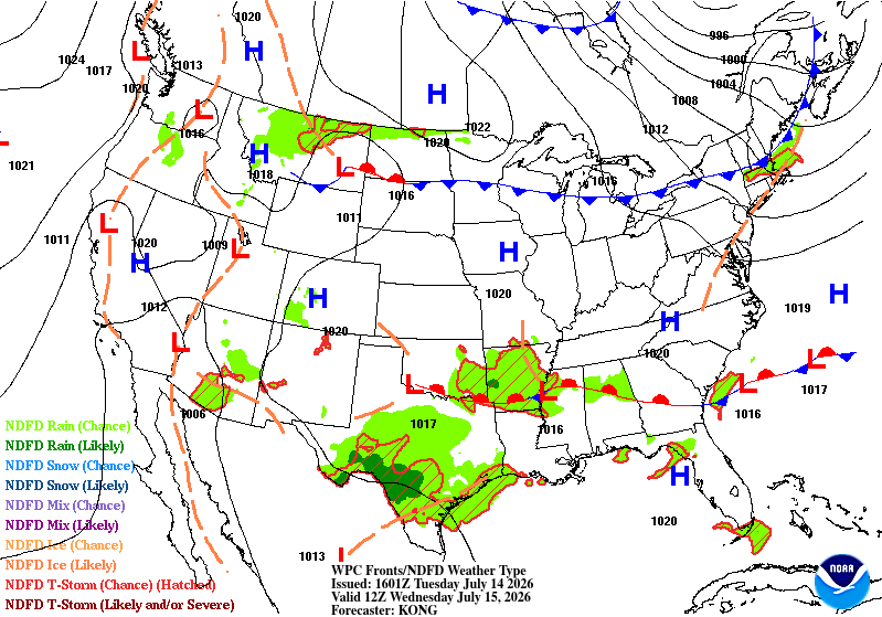
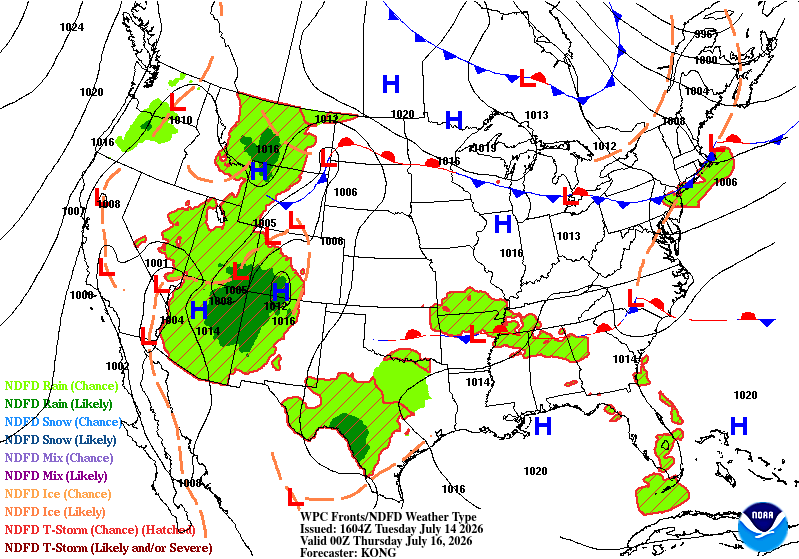
Day 2
Valid 12Z Wed Jul 15 2026 - 12Z Thu Jul 16 2026
...THERE IS A MODERATE RISK OF EXCESSIVE RAINFALL ACROSS PORTIONS
OF THE EDWARDS PLATEAU, CENTRAL RIO GRANDE VALLEY, AND HILL COUNTRY...
...Texas...
Convective cluster across the Edwards Plateau and neighboring RGV
and Hill Country will likely lead to the development of an MCV
and/or a more consolidated mid-level disturbance in the region that
will remain relatively stagnant in terms of its general motion
leading to a repeat of the same pattern that will plague the area
during the D1 period. This repeating evolution of convection is a
worst- case scenario where another round of heavy rainfall will
transpire and overlap areas that will be impacted significantly the
period prior. Multi- model consensus is basically on top of each
other in the placement of the next wave of heavy rains in the
region with additional totals of 3+ inches increasingly likely
during the D2 time frame. NBM mean QPF totals for the 48hr period
are >5" around the area of Del Rio and neighboring portions of the
Edwards Plateau. Moving towards the 75th and 90th percentile
forecasts, NBM jumps significantly into 6" and 8", respectively for
each data point. Widespread 3-6" totals are likely in the 2-day
period, but it is within the realm of possibility that additional
rainfall on D2 will push totals in areas above 10 inches, a
threshold that likely spell major flash flooding and hydrologic
impacts that will encroach more severe levels compared to the
normal scenarios from the past.
The setup continues to show great consistency within the latest
ensemble and deterministic outputs which does add value to the
forecast as this provides greater confidence in a high level event
brewing as we step through the D2 period. The previous MDT risk was
generally maintained with just some minor adjustments on the
eastern and southern flank of the risk. This period, and the event
in question will need to be monitored for a potential upgrade to a
High Risk which will likely occur once we see how the initial
evolution is transpiring. No matter the case, life-threatening
flash flooding and significant hydrologic concerns are increasingly
likely for the D2 period with the heaviest rainfall likely to occur
in the initial start of the D2 and after 00z Thursday when the
nocturnal LLJ initiates and provides a fresh low-level moisture
injection and enhanced convergence within the proximity of any
lingering disturbance. A high-end MDT risk remains in effect for
those areas referenced above with a broader MDT extension out into
Hill Country and over into the Lower Trans Pecos to Big Bend.
...Mogollon Rim into Central Arizona...
Broad upper ridge centered over the Northern U.S. will continue to
provide significant moisture advection into the interior west
leading to scattered convective signals from the Canadian border
down into the Desert Southwest with flash flood concerns in those
more susceptible areas out west. Increased confidence in a locally
favorable convective maxima has allowed for not only a continuation
of the previous SLGT risk positioned across the Mogollon Rim in AZ,
but also an expansion further northwest and north, including the
addition of Flagstaff proper. 00z HREF at the end of its temporal
range signaled widespread thunderstorm genesis over the terrain
after 20z Wednesday with some formidable heavy rain cores likely to
materialize out of the initiation. Modest neighborhood
probabilities for >1" of rainfall exist in the small window between
18-00z Wed/Thu with the highest probs situated in that terrain area
between Phoenix and Flagstaff within the Mogollon Rim across
central AZ. In coordination with the local Flagstaff WFO, have
expanded the previous SLGT risk forecast to areas northwest of
Flagstaff within the western periphery of the Mogollon Rim, as well
as a further north expansion to include Flagstaff proper given the
recent trends in guidance, and the premise of urbanization factors
providing more suitable ground conditions for flash flood
prospects.
...Lower Mississippi Valley into Southeast...
Our meandering upper level disturbance will continue to churn over
the Southern U.S. with sights on the Lower Mississippi Valley by
Wednesday afternoon. Models are within close proximity of each
other on the positioning of the disturbance with the centroid of
the circulation likely to be focused somewhere over Arkansas and
the southwest corner of TN. Elevated moisture and general diurnal
destabilization across the Lower Mississippi and Southeastern U.S.
will lead to another round of slow-moving thunderstorms capable of
producing locally heavy rainfall with rates of 2-3"/hr likely in
those stronger cell cores. The setup is not as prolific within the
QPF means compared to the previous few periods, so the threat
remains within the MRGL risk threshold. However, will continue to
monitor trends closely as we move forward in time as the chance for
a targeted upgrade, likely underneath the upper level disturbance,
is plausible.
Kleebauer
Day 2 threat area:
www.wpc.ncep.noaa.gov/qpf/98epoints.txt
Excessive Rainfall Discussion
NWS Weather Prediction Center College Park MD
1146 AM EDT Tue Jul 14 2026
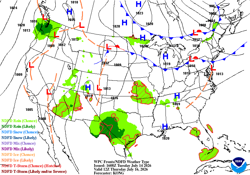
Day 3
Valid 12Z Thu Jul 16 2026 - 12Z Fri Jul 17 2026
...THERE IS A MODERATE RISK OF EXCESSIVE RAINFALL ACROSS PORTIONS
OF THE LOWER TRANS PECOS, EDWARDS PLATEAU, AND RIO GRANDE
VALLEY...
...Texas...
Convection will continue across the Edwards Plateau and surrounds
for at least one more period as the regional pattern maintains a
persistence in its evolution with yet another round of convection
lingering through the morning from the previous period, and one
last round of nocturnal convection anticipated the evening of
Thursday into early Friday morning. There is some uncertainty on
the exact location of the final convective wave that will transpire
with some guidance positioning the greatest threat a little further
north of the area likely to see the greatest impacts from the prior
periods. In any case, the threat is still very much robust for
wherever this transpires as the axis of heavy rainfall will likely
produce more totals bordering between 2-4", locally higher in the
hardest hit locations. Considering the nature of anticipated
compromised soils and ongoing flooding across portions of the RGV
and Edwards Plateau, very little additional rainfall would cause a
myriad of problems, including an exacerbation of any remnant flood
waters, especially if impacted by additional heavy rainfall >1"/hr.
There's enough of a signal to warrant an addition of a MDT risk
across the area between the Big Bend over into the Edwards Plateau
with emphasis on Val Verde county extending up to the neighboring
counties to the north, including the I-10 stretch in central
Crockett county. Considering the nature of the situation, this
period will be monitored very closely and its susceptible to larger
scale changes as the setup evolves. Heavy rain will likely enhance
life-threatening flash flooding to portions of the region for yet
another period before the setup finally looks to break after the D3
time frame.
...Southwest U.S into the Great Basin...
Another round of afternoon and evening convection will transpire
across the Southwest CONUS into the Great Basin on Thursday with
the threat carrying into the early morning periods of Friday in
some locations. Models are keen on a more robust moisture advection
pulse and general instability axis across the Desert Southwest on
Thursday with a broad axis of heavy rain prospects from the
southern border all the way north into southern UT. Ensemble bias
corrected output is very bullish on the threat in and around the
slot canyons of southern UT, along the Mogollon Rim, and down
towards the terrain embedded within Cochise, Santa Cruz, and Pima
counties. Areal average of 1-2" is forecast for the region along
the southern border with 0.75-1.25" forecast across the Mogollon
Rim and southern UT. Considering the environment maturing closer to
1000-2000 J/kg MUCAPE over much of AZ into southern UT/NV,
instability and anomalous moisture within the 90-99th percentile of
climatology across the region will produce more widespread heavy
rain prospects leading to scattered flash flood occurrences in
those more susceptible locations in the terrain. There is even some
opportunity for thunderstorm genesis off several outflows that
could impact some of the larger urban corridors within AZ,
including the Phoenix metro as the environment favors this type of
potential. A broad SLGT risk was introduced for much of AZ into
southern UT with the eastern extent out towards the NM/AZ border
into the immediate Four Corners, outlining the mean QPF closer to
0.5" within the ensembles.
Kleebauer
Day 3 threat area:
www.wpc.ncep.noaa.gov/qpf/99epoints.txt


