Excessive Rainfall Discussion
NWS Weather Prediction Center College Park MD
350 PM EDT Fri Jul 17 2026
Day 1
Valid 16Z Fri Jul 17 2026 - 12Z Sat Jul 18 2026
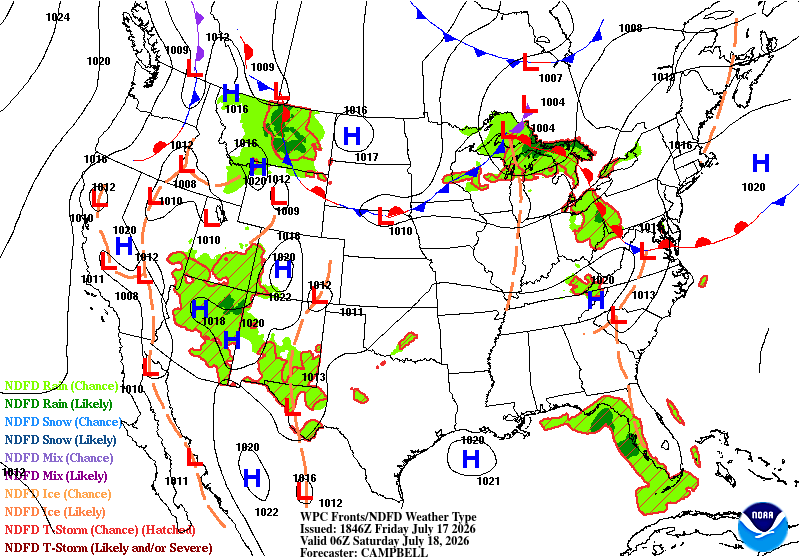
...THERE IS A SLIGHT RISK OF EXCESSIVE RAINFALL ACROSS MUCH OF WEST
TEXAS, SOUTHERN NEW MEXICO, ARIZONA, AND THE SOUTHERN GREAT
BASIN...
1600Z Update: There were 2 notable adjustments made to the Day 1
ERO, both within Slight Risk areas. The Slight Risk in western AZ
and far southeast NV was expanded westward a bit to include the Las
Vegas metro region, while the Slight across parts of Central TX was
expanded northward to include Abilene and areas east of Midland.
Both of these adjustments were based on current observational
trends (especially with the meso-enhanced vort lobe in TX), along
with the 12Z HREF and REFS QPF exceedance probabilities.
Hurley
Previous discussion...
...Western U.S....
A persistent monsoonal pattern will remain in place across the
West, supporting widespread convective coverage. Standardized
moisture anomalies of 2-3+ std dev extend from Arizona and
southern California to the northern Rockies, sustaining a broadly
unstable environment conducive to highly efficient rainfall.
A "high-end" Slight Risk remains centered along northern Arizona's
Mogollon Rim. The HREF and REFS guidance have remained consistent
in signaling the potential for localized amounts of 3+ inches in
this area, raising the potential for scattered to localized
significant flash flooding, especially given the already moist soil
conditions. Additionally, the Slight has been expanded eastward to
encompass portions of northeastern Arizona and northwestern New
Mexico, where HREF and REFS are also indicating the threat for
localized heavy amounts (2-3 inches).
Farther south and east, storms are expected to develop along the
Sacramento Mountains of southern New Mexico, threatening active
wildfire burn scars susceptible to rapid runoff.
...Texas...
Lingering mid-level energy over south-central Texas will slowly
track north and west on Friday. The overnight hi-res models
continued to suggest significantly less coverage of heavy amounts
than in previous days. However, remaining deep moisture, along
with a revitalized 30+ kt low level jet, will maintain at least a
localized threat for additional heavy rains and therefore a Slight
Risk covering much of Southwest to South-Central Texas was
maintained. Fortunately, the general consensus of the HREF and REFS
indicates the greater threat for heavy amounts will center west of
the areas most severely impacted earlier this week and closer to
the Davis Mountains today. Farther north, moisture and energy
lifting out will carry some potential for localized heavy rain and
perhaps isolated flash flooding into parts of Northwest Texas,
where a broad Marginal Risk was maintained.
...Western Florida...
A cut-off 500mb low lingering over the eastern Gulf will reside in
a favorable environment for highly-efficient rainfall (PWs at or
above 2 inches, MLCAPE over 1,000 J/kg, and deep warm-cloud
depths). This will easily support rainfall rates exceeding 3 in/hr.
Therefore, a Marginal Risk was maintained along portions of
Florida's West Coast, highlighting the potential for isolated
runoff concerns, especially in urbanized areas.
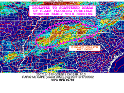
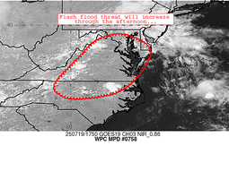
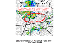
...Ohio/Tennessee Valley to the Central/Southern Appalachians...
A Marginal Risk was maintained as a broad, high-PW airmass
continues to spread north and east, with the expectation that
diurnally-driven storms may produce isolated, short-duration
runoff concerns this afternoon and evening.
...Northern Great Lakes...
A progressive upper trough and associated jet max diving into
northern Minnesota will initiate nocturnal convection from northern
Minnesota into Upper Michigan. While rapid storm motions should
limit widespread heavy accumulations, anomalous moisture and
localized training profiles may produce isolated runoff concerns
within the area highlighted by the Marginal Risk.
Pereira
Day 1 threat area:
www.wpc.ncep.noaa.gov/qpf/94epoints.txt
Excessive Rainfall Discussion
NWS Weather Prediction Center College Park MD
350 PM EDT Fri Jul 17 2026
Day 2
Valid 12Z Sat Jul 18 2026 - 12Z Sun Jul 19 2026
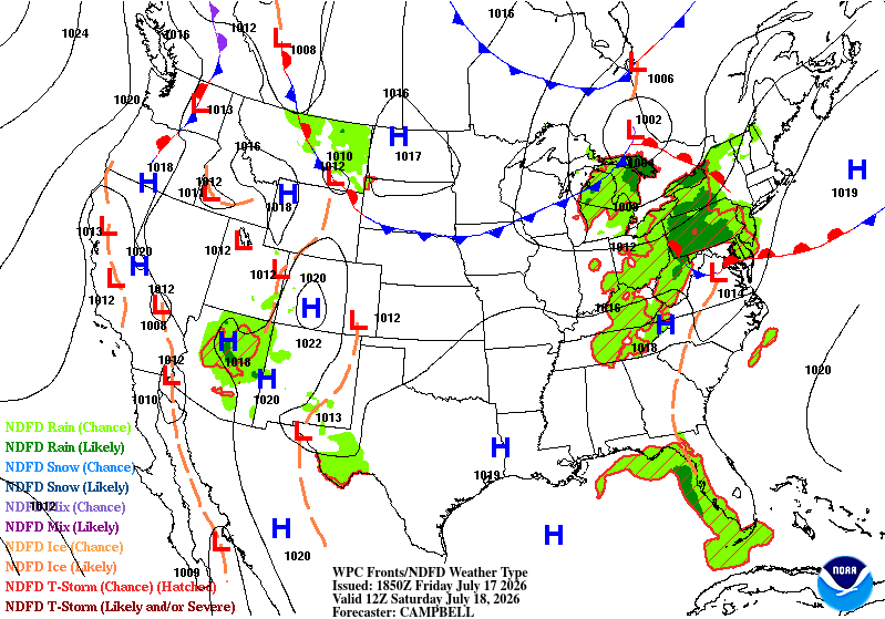
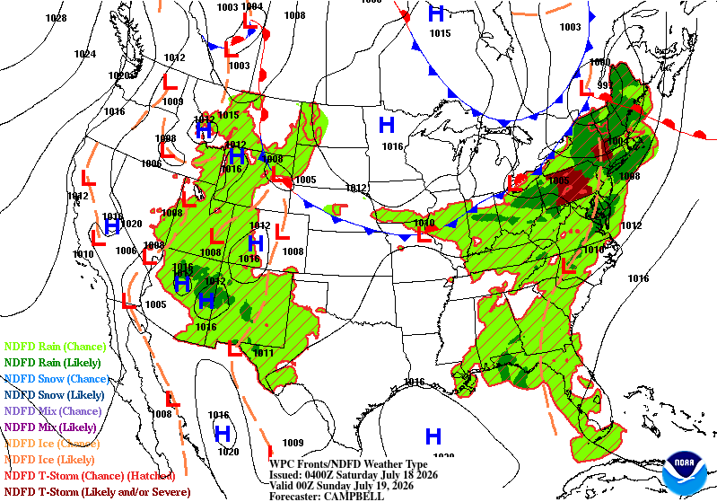
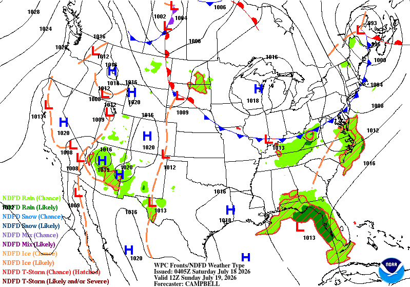
...THERE IS A SLIGHT RISK OF EXCESSIVE RAINFALL OVER PORTIONS OF
THE FOUR CORNERS AND SOUTHWEST, AND ACROSS PARTS OF THE UPPER MID
ATLANTIC INTO SOUTHERN NEW YORK AND NEW ENGLAND...
2000 UTC Update: The most notable change to the Day 2 ERO was the
eastward and northward expansion of the Slight Risk area across
northeast AZ, southeast UT, central NM, and into southwest CO. The
expansion incorporates the Slot Canyons across southern UT, and was
supported by the high HREF and REFS probabilities (>50%) of hourly
rainfall rates of at least .50". Maximum FFG probabilities (40km
neighborhood probs) of the 1/3/6 hr FFG peak above 25% in these
areas per the 12Z HREF, while climb above 40% (over 70% in northern
AZ) per the 12Z REFS. Based on the 00Z guidance, and particularly
over UT, the ECMWF EFI does indicate spotty values over 0.7, with
shift- of- tails values < 1.0.
In addition, also based on the latest guidance/trends (particularly
the CAMs), have expanded the Slight Risk over the Northeast to
include more of CT, southern NY, eastern PA, much of NJ, and far
northern DE. Quite a few CAMs show spotty 3-5" totals ahead of the
mid/upper shortwave and associated surface cold front, with the 12Z
REFS showing 30-40% probabilities of >5.00" across CT-RI and
southern MA.
Hurley
Previous discussion..
...Western U.S.....
An expansive monsoonal convective pattern remains locked in place
across the Western CONUS, supporting the continuation of a broad
Slight Risk extending from West Texas and southern New Mexico
northwestward across central and northern Arizona into southern
Utah. An increase in low level moisture transport into the region,
coupled with the moisture already in place will support PW
anomalies 1.5-3 std dev above normal across much of this region.
This moisture will likely once again support widespread convective
development across the area. With ample daytime heating and
sufficient instability, these storms will be capable of producing
efficient rainfall rates. Given the history of recent
precipitation, soils have become increasingly sensitive across
portions of the region, elevating the potential for rapid runoff
and flash flooding concerns.
...Ohio Valley/Appalachians to the Mid Atlantic and Northeast...
A progressive cold front dropping southeastward will interact with
an anomalously moist airmass pooling ahead of it. Atmospheric
profiles will be highly favorable for efficient warm-rain
processes, featuring PWs over 2 inches and deep warm-cloud layers.
Where daytime heating and mid-70s dewpoints break capping
inversions, prefrontal convection will tap into greater instability
and raise rainfall rates.
This environment along with the concentration of urbanized areas
susceptible to fast runoff provided enough confidence to extend
the Slight Risk farther east from parts of eastern Pennsylvania and
northern New Jersey across southern New York and New England.
Limiting factors to highlighting a more widespread flash flooding
threat include fast storm moisture and lingering model discrepancy
regarding the exact placement of the heaviest precipitation axes.
Farther west through the central Appalachians into the Ohio Valley,
a broader Marginal Risk remains in place to cover what is
anticipated to be more isolated concerns.
...Florida Gulf Coast into Southeast Alabama and Southwest Georgia...
Deep tropical moisture and a slow-moving mid-to-upper level low
over the eastern Gulf will maintain a heavy rainfall threat, which
translates into the Day 3 ERO. Model QPFs have come up in this
area, now within the CAM windows, with high (>60%) probabilities of
24hr QPF exceeding 3" per both the 12Z HREF and REFS. Both are also
fairly bullish with the >5" probabilities west of the FL Big Bend
(30-40% per the HREF, 40-50% per the REFS).
Hurley/Pereira
Day 2 threat area:
www.wpc.ncep.noaa.gov/qpf/98epoints.txt
Excessive Rainfall Discussion
NWS Weather Prediction Center College Park MD
350 PM EDT Fri Jul 17 2026
Day 3
Valid 12Z Sun Jul 19 2026 - 12Z Mon Jul 20 2026
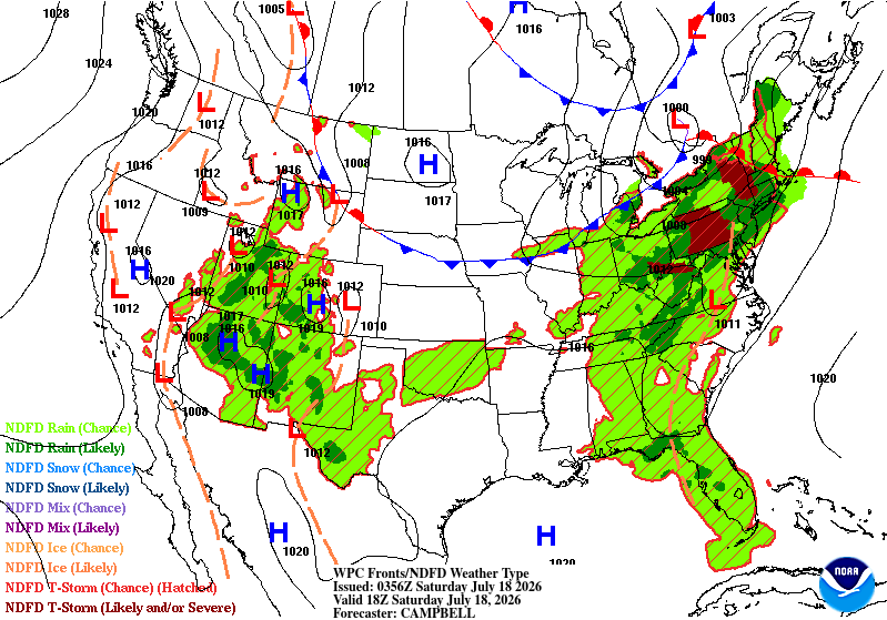
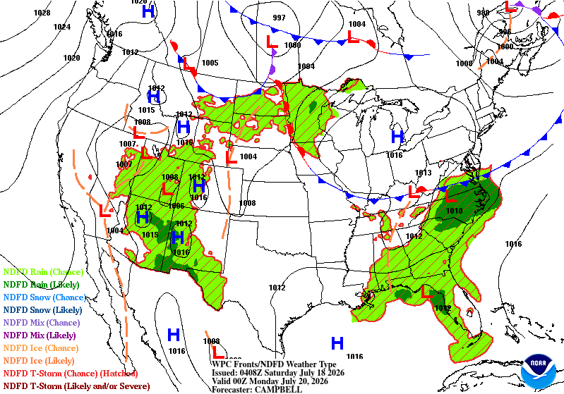
...THERE IS A MARGINAL RISK OF EXCESSIVE RAINFALL OVER PORTIONS OF
THE WESTERN U.S., SOUTHEAST, AND LOWER MID ATLANTIC...
2000 UTC Update: Minor changes were made to the Day 3 ERO, based on
the latest (12Z) guidance suite. Per collaboration with WFO RAH,
felt that an expansion of the Marginal Risk area into central NC
and northeast SC was warranted. Have also expanded the Marginal
along the eastern Gulf Coast, while again nudging the western
periphery of the Marginal Risk to include more of southern NV
(including Las Vegas) and portions of southeast CA.
Not much change in the overall monsoonal pattern, though most of
the global guidance is a bit more diffuse with the heavier QPF
totals. Still think a Slight Risk will be likely somewhere,
probably very similar to the Slight Risk area on the current Day 2
ERO, but for now given the variance in the model QPFs, will keep
the Marginal Risk going and reassess with the next 1-2 forecast
cycles.
Hurley
Previous discussion...
...Western U.S....
The monsoon pattern will persist across the Western CONUS,
maintaining at least scattered convection from the West Texas, New
Mexico and Arizona into the Great Basin and Rockies. PW anomalies
of 2-3+ standard deviations will continue to center over portions
of the Great Basin. The higher areal average precipitation amounts
are expected to once again align along the Mogollon Rim into
southern Utah. Given the prior rainfall and moist soil conditions,
these areas will remain vulnerable to rapid runoff, with the
area's complex terrain and slot canyons raising localized concerns.
A broad Marginal Risk was maintained to highlight the daily
convective potential and runoff concerns.
...Florida Gulf Coast...
Deep tropical moisture and a slow-moving mid-to-upper level low
over the eastern Gulf will maintain a heavy rainfall threat.
Favorable low-level convergence along the eastern flank of the
system may produce heavy rainfall along Florida's West Coast. Some
models show the system lifting out to the north this period,
bringing the threat for heavy rain into the Big Bend region. A
Marginal Risk was maintained from the Tampa Bay area to the Big
Bend to highlight the potential for heavy rain along this area.
...Virginia Tidewater and Eastern North Carolina....
A cold front dropping out of the north is expected to slow across
this region, maintaining a deep moisture pool in advance. Pre-
frontal convergence and diurnal heating will likely produce pockets
of heavy, slow-moving thunderstorms prior to its passage. With
some differences in the details, model consensus continues to
indicate that 1-2 inch, with locally heavier amounts, are likely
within the Marginal Risk area, producing at least isolated concerns.
A targeted upgrade to a Slight may be required, especially if the
model consensus for heavy amounts begins to center across the more
vulnerable Tidewater region.
Pereira
Day 3 threat area:
www.wpc.ncep.noaa.gov/qpf/99epoints.txt
Excessive Rainfall Discussion
NWS Weather Prediction Center College Park MD
350 PM EDT Fri Jul 17 2026
Day 4 and Day 5
Valid 12Z Mon Jul 20 2026 - 12Z Wed Jul 22 2026
...THERE IS A MARGINAL RISK OF EXCESSIVE RAINFALL ACROSS PORTIONS
OF THE NORTHEAST/MID ATLANTIC REGION AS WELL AS THE WESTERN US...
2030Z Discussion
Introduced a Marginal Risk area on Day 4 from the Great Lakes to
the Mid Atlantic region on Day 4 given a strengthening signal in
both the operational models and ensemble QPF guidance and the
magnitude of the moisture in place. Also made some minor
adjustments on Day 5 in the Northeast US and Mid-Atlantic region.
Maintained continuity in Florida and coastal Southeast US as an
area of low pressure tracks across the Florida peninsula. No change
needed in the West where weak and difficult-to-time shortwave
energy and anomalous moisture lingers on the western periphery of
an upper high in region of broad ridging.
Bann
Previous Discussion...
...Western U.S...
A continuation of a traditional monsoonal pattern will continue
across the Western CONUS with scattered to widespread bouts of
locally heavy to excessive rainfall each day across much of the
Desert Southwest up through the Great Basin and into portions of
the Rockies. Deep moisture will be drawn northward around the
periphery of a building upper high extending from the Great Basin
to the Southern Plains. This sets up a well-defined axis of
elevated instability coupling with precipitable water anomalies
between +2 and +3 standard deviations above climatology for
July...with the strongest anomalies situated over Nevada and Utah.
QPF maxima are currently situated within the Mogollon Rim and
portions of southern Utah...both of which are the more susceptible
areas given the complex topography and slot canyons. Broad MRGL
risks exist for both days in similar locations outlining much of
the aforementioned area(s) above although short term upgrades in
spots are not our of the question.
...Florida...
Models continue to depict heavy rainfall across portions of the
northern Florida peninsula on Monday (Day 4) which spreads farther
northward in association with an area of low pressure. Ensemble
QPF for both periods indicate multiple inches of rain. This
continues to be a period to monitor for the prospects of this
being something becoming more organized than what the latest model
guidance indicates. For now, MRGL risks exist on both D4 and D5
for the threat of heavy rainfall.
Northeast US...
The deepening of a mid- and upper level trough by a digging upper
level jet will push a surface cold front into the Northeast US.
Deep moisture gets drawn northeastward ahead of the digging system
and should be in place as convection develops in vicinity of the
front. With such a moist environment and favorable low level
instability along with the upper support afforded by the
jet...downpours that lead to heavy or excessive rainfall amount are
possible.
Bann


