| WPC Met Watch |
|
|
Mesoscale Precipitation Discussion: #0211 |
|
(Issued at 126 AM EDT Fri May 03 2024
) |
|
| MPD Selection |
|
|
|
|
|

Mesoscale Precipitation Discussion 0211
NWS Weather Prediction Center College Park MD
126 AM EDT Fri May 03 2024

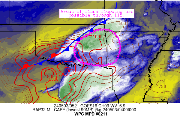
Areas affected...eastern Oklahoma, far western Arkansas

Concerning...Heavy rainfall...Flash flooding possible

Valid 030526Z - 031126Z

Summary...A convective cluster has recently expanded in coverage
along an axis from near Tahlequah to near Shawnee.  Slow movement
and localized training has allowed for areas of 2-2.5 inch/hr rain
rates to develop.  Localized flash flood potential exists as a
result.

Discussion...Storms have recently intensified and expanded in
coverage along and just ahead of a cold front along the I-44
corridor from Tulsa to Oklahoma City.  Ahead of this front, modest
wind fields at the surface and aloft are allowing for slow
eastward movement of cells amid an environment characterized by
1000-1500 J/kg MLCAPE and 1.5 inch PW values, supporting efficient
rainfall production beneath the storms.  The slow eastward
movement and orientation has also allowed for areas of 2-2.5
inch/hr rain rates to develop in spots between Tahlequah and
Shawnee - highest where cell mergers and local training has been
most pronounced.  These rates were exceeding local FFG (ranging
from 1-2 inch/hr) across the area.

The ongoing scenario is expected to translate slowly southward and
eastward over the next 4-6 hours.  Weak low-level shear will allow
for cells to grow upscale into one or two forward-propagating
linear segments that continue to produce locally heavy rainfall
and at least 1 inch/hr rain rates through parts of the discussion
area.  FFG thresholds will continue to be approached or locally
exceeded in at least a few locales through 11Z across the
discussion area.  Isolated to scattered instances of flash
flooding are possible as a result.

Cook

ATTN...WFO...LZK...OUN...SGF...SHV...TSA...

ATTN...RFC...ABRFC...LMRFC...NWC...

LAT...LON   36599484 36369399 35589351 34789357 34199384
            33899463 33989585 34319670 35049694 35699661
            35979624 36379554
Download in GIS format: Shapefile
| KML
Last Updated: 126 AM EDT Fri May 03 2024
|


