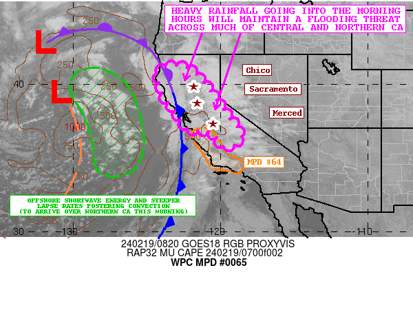
| WPC Met Watch |
|
|
Mesoscale Precipitation Discussion: #0065 |
|
(Issued at 345 AM EST Mon Feb 19 2024
) |
|
| MPD Selection |
|
|
|
|
|

Mesoscale Precipitation Discussion 0065
NWS Weather Prediction Center College Park MD
345 AM EST Mon Feb 19 2024

Areas affected...Much of Central and Northern CA

Concerning...Heavy rainfall...Flash flooding possible

Valid 190845Z - 191830Z

SUMMARY...A threat of heavy rainfall will continue for the
remainder of the night and into the morning hours as a strong low
center persists offshore of the West Coast. This will maintain a
threat of flooding given the locally saturated ground conditions.

DISCUSSION...A deep low center offshore of the West Coast
associated with an upper-level trough will continue to advance
gradually off to the east over the next 6 to 12 hours which will
allow a cold front to advance inland across central and northern
CA. A rather well-defined atmospheric river of Pacific moisture
continues to advance north around the eastern flank of the deep
layer trough/low and this will maintain a threat of heavy rainfall
going through the remainder of the night and into the morning
hours for much of the region.

The axis of strongest warm air advection/isentropic ascent and
deep layer moisture transport will be across the San Joaquin and
Sacramento Valleys as well the west-facing slopes of the Sierra
Nevada. Locally enhanced low-level jet energy of 40 to 50+ kts
continues to lift northward up through the Central Valley, and the
latest RAP analysis continues to show a modest axis of instability
with MUCAPE values of as much as 100 to 250 J/kg. This coupled
with some locally strong low-level moisture convergence over the
Central Valley and near the foothills of the Sierra Nevada
continue to support some occasionally stronger convective elements
with heavier rainfall rates.

Rainfall rates within the main warm conveyor belt along and ahead
of the cold front will have the capability to occasionally reach
into the 0.50" to 0.75"/hour range with some spotty heavier rates
possible where any stronger convective cells materialize. Behind
the cold front, there should tend to be a break in the coverage of
moderate to heavy rainfall, but eventually there will be the
arrival of additional shortwave energy from offshore along with
the arrival of steeper mid-level lapse rates. This coupled with
orographics is likely to result in some redeveloping yet broken
lines of showers and thunderstorms. The 00Z HREF and especially
the HRRR tend to favor the Bay Area, northern CA coastal ranges,
and the northern Sacramento Valley as having the best potential of
seeing these semi-organized bands of convection this morning.

Along and ahead of the cold front, additional rainfall totals of
as much as 2 to 4 inches with isolated heavier amounts can be
expected for the upslope areas of the Sierra Nevada below the snow
line, with eastern portions of the Central Valley seeing as much
as 1 to 2 inches. The areas that do see more discrete convection
redeveloping early this morning closer back to the Bay Area and up
north across the coastal terrain and northern Sacramento Valley
may also see some additional 1 to 2 inch amounts.

Given the heavy rainfall that has already occurred, and with
locally saturated ground conditions, these additional rains should
maintain a flooding threat going into the morning hours.

Orrison

ATTN...WFO...EKA...HNX...MFR...MTR...STO...

ATTN...RFC...CNRFC...NWC...

LAT...LON   41252339 41012207 39862093 38451992 38271982
            37531929 37111884 36621857 36161873 35791923
            35801978 36182012 36682048 36972100 36922139
            36822173 36922208 37242251 38202304 38632349
            39262391 39832397 40372439 40982413
Download in GIS format: Shapefile
| KML
Last Updated: 345 AM EST Mon Feb 19 2024
|


