| WPC Met Watch |
|
|
Mesoscale Precipitation Discussion: #0171 |
|
(Issued at 214 PM EDT Thu Apr 25 2024
) |
|
| MPD Selection |
|
|
|
|
|

Mesoscale Precipitation Discussion 0171
NWS Weather Prediction Center College Park MD
214 PM EDT Thu Apr 25 2024

Areas affected...eastern KS, western MO into far northeastern
OK/northern AR and southeastern NE

Concerning...Heavy rainfall...Flash flooding possible

Valid 251812Z - 260000Z

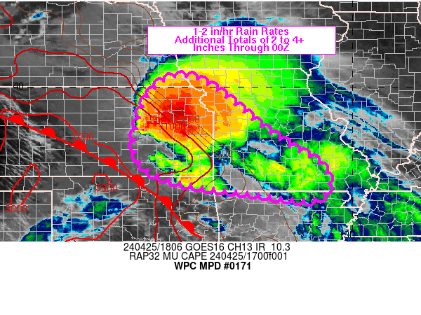
SUMMARY...A fairly broad NW to SE oriented risk of flash flooding
will be in place through 00Z for portions of eastern KS, western
MO into far northeastern OK/northern AR and southeastern NE. Peak
rainfall rates of 1-2 in/hr and additional totals of 2 to 4+
inches are expected through 00Z.

DISCUSSION...3 hour duration loops of GOES East infrared imagery
showed two organized areas of colder cloud tops over the central
U.S., the first over southwestern/southern MO and the second
advancing across northeastern KS. Cloud tops were warming with the
southwestern/southern MO cluster as it advances farther east into
a more stable environment but the northeastern KS cluster was
forward propagating toward the southeast at 15-25 kt, following
modified Corfidi vectors with inflow in the 850-700 mb layer,
along a MUCAPE gradient of 500 to 1000+ J/kg via the 18Z SPC
mesoanalysis. Additional, less organized, cells were observed via
radar imagery along the eastern KS/OK border, with movement toward
the ENE at 20-30 kt. The broader region of thunderstorms were
located northeast of a warm front lifting northeast across KS/OK
at 18Z.

Elevated convergence oriented NW to SE, maximized in the 850-700
mb layer, was helping to support the ongoing areas of
thunderstorms with a mean movement toward the east. This overall
mean motion is expected to continue as the elevated convergence
axis/front aloft translates toward the northeast through 00Z.
Periods of training within the unstable airmass are likely with
new development to the immediate west of the ongoing activity.
Rainfall rates are likely to peak in the 1-2 in/hr range where
west to east training occurs, and additional rainfall totals of 2
to 4 inches (locally higher) are expected through 00Z. While there
may be some slight overlap of additional rainfall with an
estimated 3-6 inches which impacted portions of I-44 between
Joplin and Springfield through 18Z, the majority of additional
rainfall is expected to be north/east of those heavily impacted
areas.

Otto

ATTN...WFO...EAX...ICT...LSX...LZK...OAX...PAH...SGF...TOP...
TSA...

ATTN...RFC...ABRFC...LMRFC...MBRFC...NCRFC...NWC...

LAT...LON   40309597 40029473 38429274 37249094 36289114
            36439312 36929611 37779721 39529688
Download in GIS format: Shapefile
| KML
Last Updated: 214 PM EDT Thu Apr 25 2024
|


