| WPC Met Watch |
|
|
Mesoscale Precipitation Discussion: #0203 |
|
(Issued at 325 PM EDT Wed Apr 30 2025
) |
|
| MPD Selection |
|
|
|
|
|

Mesoscale Precipitation Discussion 0203
NWS Weather Prediction Center College Park MD
325 PM EDT Wed Apr 30 2025

Areas affected...Central to Northeast TX...Far Southwest AR...Far
Northwest LA

Concerning...Heavy rainfall...Flash flooding likely

Valid 301925Z - 010125Z

SUMMARY...A complex of heavy showers and thunderstorms will
continue to gradually settle south and east going through the
afternoon and early evening hours. Intense rainfall rates and
storm totals will likely promote additional areas of flash
flooding which will include locally considerable/significant urban
flash flooding impacts.

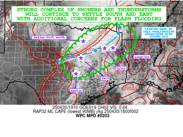
DISCUSSION...The afternoon GOES-E visible satellite imagery shows
a substantial amount of CU/TCU development across central to
northeast TX out ahead of a well-defined and long-lived MCS that
has been transiting northern TX and eastern OK over the last
several hours. The warm-sector airmass with the aid of strong
diurnal heating and a moisture-laden boundary layer with surface
dewpoints in the upper 60s to low 70s is affording MLCAPE values
as high as 1500 to 3000 J/kg. This includes the Austin to Waco
corridor on northeastward up into the Tyler and Longview vicinity.

A combination of strong instability and enhanced moisture flux
convergence with the aid of a southerly low-level jet of 40 to 50
kts will continue to favor a well-organized southern flank of the
larger scale convective mass. The convergent nature of the moist
low-level wind field and with favorable low to mid-level shear
profiles (0-3 km bulk shear of 30 to 40 kts) should continue to
sustain enhanced convective cores with rainfall rates reaching as
high as 1 to 3 inches/hour.

The concern going into the evening hours will be the increasing
threat for the southwest flank of the convective line to begin
slowing down as upstream mid-level height falls begin to
increasingly overspread the broader southern Plains region, and
with the deeper layer flow becoming more aligned with the leading
edge of the surface cold pool/outflow boundary orientation.
Cell-training concerns with backbuilding convection may extend in
time as far southwest as the Austin metropolitan area itself, but
greater short-term concerns are expected along the Waco to Tyler
corridor and stretching east through Tyler and Longview. Some of
the convection will also advance into far southwest AR and
northwest LA, but generally the heaviest rainfall should be for
areas farther down to the southwest over central to northeast TX.

Recent runs of the HRRR/RRFS guidance and also the experimental
WoFS indicate potential for as much as 3 to 6 inches of rain where
the greatest cell-training concerns set up, and this will promote
additional areas of flash flooding with a concern at least locally
for considerable/significant urban flash flooding impacts.

Orrison

ATTN...WFO...EWX...FWD...HGX...OUN...SHV...SJT...TSA...

ATTN...RFC...ABRFC...LMRFC...WGRFC...NWC...

LAT...LON   34059415 33699330 32959312 32199366 31049538
            30359680 30319798 30969847 31949822 33459674
            34019538
Download in GIS format: Shapefile
| KML
Last Updated: 325 PM EDT Wed Apr 30 2025
|


