| WPC Met Watch |
|
|
Mesoscale Precipitation Discussion: #0217 |
|
(Issued at 518 PM EDT Fri May 03 2024
) |
|
| MPD Selection |
|
|
|
|
|

Mesoscale Precipitation Discussion 0217
NWS Weather Prediction Center College Park MD
518 PM EDT Fri May 03 2024

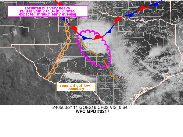
Areas affected...west-central TX

Concerning...Heavy rainfall...Flash flooding likely

Valid 032118Z - 040300Z

Summary...An evolving complex of thunderstorms across west-central
TX is expected to result in at least localized flash flooding
through 03Z. Slow moving and merging of cells will be capable of
localized rainfall rates of 2 to 3+ in/hr.

Discussion...21Z radar imagery showed a cluster of thunderstorms,
including a slow moving supercell over Coke County with
MRMS-derived rainfall rates of 2 to 3 in/hr. 20Z surface
observations showed the storms, with some splitting nature
observed, located near the intersection of a stationary front and
remnant outflow boundary that extended southeastward from east of
SPG to just north of SJT to west of ERV. 21Z SPC mesoanalysis data
indicated MLCAPE of 2000 to ~3500 J/kg east of a dryline in West
Texas along with PWAT values near 1 inch which increased with
eastward/southeastward extent. Bunkers right moving cell motions
are forecast to range from about 5 to 15 kt toward the southeast
(via RAP guidance), with the remnant outflow boundary possibly
acting as a focus for future cell development, including a
recently developed cell northeast of SJT. Storm scale interactions
fostering slow to stationary cell movement at times along with
cell mergers may result in periods of time with a prolonged period
of intense rainfall over a given location, perhaps 2 to 3+ in/hr.

19Z and 20Z WoFS guidance showed probabilities of at least 50
percent for hourly rainfall in excess of 2 inches through 01Z
along with 60 to 80 percent probabilities of exceeding 3 inches of
rain along a relatively narrow axis extending near the outflow
boundary through 02Z. 3 to 5 inches of rain across portions of
west-central TX, perhaps along a fairly narrow axis, is expected
to result in areas of likely flash flooding through the early
evening (~03Z). An increase in the low level jet near/beyond 00Z
should be accompanied by increased lift across storm-induced
outflow and possible increased coverage of storms across the
region. While possibly staying localized, areas of flash flooding
appear likely across the MPD threat area.

Otto

ATTN...WFO...MAF...SJT...

ATTN...RFC...WGRFC...NWC...

LAT...LON   32930098 32850036 32379975 31429926 30529924
            30459992 31040072 31740126 32600142
Download in GIS format: Shapefile
| KML
Last Updated: 518 PM EDT Fri May 03 2024
|


