| WPC Met Watch |
|
|
Mesoscale Precipitation Discussion: #0243 |
|
(Issued at 432 PM EDT Thu May 08 2025
) |
|
| MPD Selection |
|
|
|
|
|

Mesoscale Precipitation Discussion 0243
NWS Weather Prediction Center College Park MD
432 PM EDT Thu May 08 2025

Areas affected...southern NY into southern/central New England

Concerning...Heavy rainfall...Flash flooding possible

Valid 082030Z - 090130Z

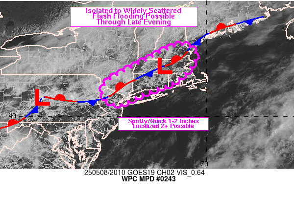
Summary...Isolated to widely scattered areas of flash flooding
will be possible across parts of southern NY into southern/central
New England through late evening. Hourly rainfall of 1-2 inches
with localized totals between 2 and 3 inches will be possible with
activity likely diminishing in coverage and intensity after
sunset.

Discussion...20Z visible satellite and radar imagery showed
scattered showers and thunderstorms in the vicinity of a wavy
stationary front analyzed from coastal ME into southern
NY/northern NJ. Earlier breaks in cloud cover and daytime heating
have allowed for the development of weak instability (MLCAPE up to
and locally in excess of 500 J/kg along the front over southern
New England via SPC mesoanalysis). GPS data showed PWATs were
modest, hovering near 1 inch but cell motions should be a bit
slower, somewhere between 10-20 kt from the southwest.

The coverage of showers and thunderstorms is expected to increase
within the corridor between the front and a sea breeze boundary
over southern CT into RI over the next couple of hours. The front
is also forecast by the RAP to sweep southward, west of a surface
low in east-central MA. Cell mergers, subsequent outflow and brief
training with similar cell movement and boundary orientations
could support a few spots with hourly rainfall between 1-2 inches
and perhaps storm totals between 2 and 3 inches prior to expected
dissipation after the loss of daytime heating.

The expected total rainfall is certainly on the low side, but it
may fall somewhat quickly atop a region of the Northeast which has
seen 200 to 400+ percent of average rainfall over the past 7 days,
leaving soil moisture values above average. This fact, combined
with the urban nature of the region and rush hour could result in
isolated to widely scattered instances of flash flooding over the
next 3-5 hours.

Otto

ATTN...WFO...ALY...BGM...BOX...GYX...OKX...PHI...

ATTN...RFC...MARFC...NERFC...NWC...

LAT...LON   43377142 43217065 42647056 41757136 41257259
            40927338 40577412 40657450 40757467 40967485
            41227493 41747460 42637294
Download in GIS format: Shapefile
| KML
Last Updated: 432 PM EDT Thu May 08 2025
|


