| WPC Met Watch |
|
|
Mesoscale Precipitation Discussion: #0249 (2022) |
|
(Issued at 1217 PM EDT Wed May 25 2022
) |
|
| MPD Selection |
|
|
|
|
|

Mesoscale Precipitation Discussion 0249
NWS Weather Prediction Center College Park MD
1217 PM EDT Wed May 25 2022

Areas affected...FL Panhandle...South-Central AL...Ext Southwest
GA...

Concerning...Heavy rainfall...Flash flooding possible

Valid 251615Z - 252100Z

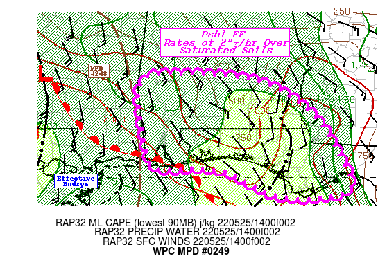
SUMMARY...Additional convective development noted over the Gulf
Coast could trigger additional flash flooding this afternoon.

DISCUSSION...Recent RADAR mosaic highlights the training complex
across the central FL Panhandle into SE AL remains oriented along
an 850 mb confluence axis with slowing eastward propagation...in
line with RAP analysis and forecast propagation vectors. The slow
eastward propagation of this complex has allowed a favorable moist
and unstable environment (2" PWATS and 1000-1500 J/kg MLCAPE) to
be fluxed into the cells, allowing them to maintain intensity for
another 1-2 hours before moving across the tight NNW to SSE
moisture gradient and weaken/dry out. Additional localized hourly
rainfall totals of 2-3" are possible with this activity as the
storms migrate north and east continuing a flash flood/rapid
inundation risk over the saturated ground conditions.

Meanwhile upstream, additional thunderstorm development is noted
to the southwest of this complex offshore the Florida Peninsula in
the moisture/instability pool. 15Z subjective mesoscale analysis
highlighted an effective warm front/confluence zone that extends
back across coastal AL/MS toward a meso-low along the approaching
squall line in SW MS. RADAR denotes a few weaker/shallower cells
developing along this enhanced convergence boundary locally
increased with frictional convergence of 20kt onshore winds
slowing to backed 5kt winds onshore.  South of the boundary,
within the warm sector, the airmass characterized by increasingly
unstable  MLCAPE values ~2000 J/kg and sufficient PWATS ~1.9". As
these maturing storms propagate north with the 850-300 mb mean
flow and interact with this boundary, enhanced low level
convergence will result in rain rates 2"+/hour.  Given this aligns
with recent rainfall from earlier this morning with areal rain
averages of 2-3" and embedded locally higher 4-6"; expect these
additional rains to have increased runoff and result in possible
flash flooding/rapid inundation this afternoon.

Asherman/Gallina

ATTN...WFO...BMX...MOB...TAE...

ATTN...RFC...LMRFC...SERFC...NWC...

LAT...LON   32148752 31988599 31368494 30528436 29748414
            29608548 30148671 30198754 30178805 30568830
            31938841
Last Updated: 1217 PM EDT Wed May 25 2022
|


