| WPC Met Watch |
|
|
Mesoscale Precipitation Discussion: #0249 |
|
(Issued at 156 PM EDT Sat May 10 2025
) |
|
| MPD Selection |
|
|
|
|
|

Mesoscale Precipitation Discussion 0249
NWS Weather Prediction Center College Park MD
156 PM EDT Sat May 10 2025

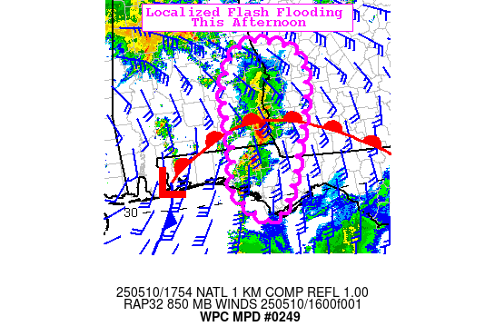
Areas affected...Florida Panhandle into Alabama and Georgia

Concerning...Heavy rainfall...Flash flooding possible

Valid 101756Z - 102256Z

SUMMARY...Repeating thunderstorms moving north from the eastern
Florida Panhandle into Alabama and Georgia rest of this afternoon
may result in localized flash flooding.

DISCUSSION...A multi-cell thunderstorm cluster with hourly
rainfall rates of 1.5-2"/hr has developed from the eastern FL
Panhandle through far southeast AL per regional radar. This
activity expanded in the past couple of hours from an isolated
supercell in a renewed warm conveyor belt lifting from the Gulf
east of an upper low centered over southern MS. PW of 1.75" and
MLCAPE >1500 J/kg in this axis will enable further development.
Strong southerly flow from the Gulf around 35kt and a warm frontal
boundary across this axis will allow this development to continue
to be along the axis, causing repeating heavy thunderstorms and
thus a flash flood risk.

Recent HRRR runs depict a risk of 2-4" rainfall over the next few
hours. Areas in the eastern FL Panhandle received 3-5" rainfall
since last night where vulnerability is greater. Areas in
southeast AL/southwest GA have only received around an inch of
rain over the past week and are less vulnerable. Localized flash
flooding will be possible where the most repeating occurs and over
more urbanized locations.

Jackson

ATTN...WFO...BMX...FFC...TAE...

ATTN...RFC...SERFC...NWC...

LAT...LON   32938504 32498415 31098441 29608515 30198600
            30888589 31978595 32728564
Download in GIS format: Shapefile
| KML
Last Updated: 156 PM EDT Sat May 10 2025
|


