| WPC Met Watch |
|
|
Mesoscale Precipitation Discussion: #0340 (2023) |
|
(Issued at 1155 PM EDT Thu May 25 2023
) |
|
| MPD Selection |
|
|
|
|
|

Mesoscale Precipitation Discussion 0340
NWS Weather Prediction Center College Park MD
1155 PM EDT Thu May 25 2023

Areas affected...eastern MT

Concerning...Heavy rainfall...Flash flooding possible

Valid 260353Z - 260745Z

SUMMARY...A localized flash flood threat will exist over portions
of eastern MT for another 2-4 hours with rainfall rates of 1-1.5
in/hr. The threat is expected to rapidly diminish after 07z.

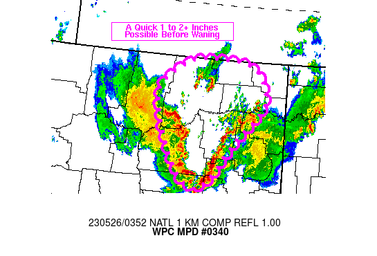
DISCUSSION...Regional radar imagery at 0345Z showed two axes of
convection converging across the eastern MT High Plains, as if
like a zipper, with a V-shape in the reflectivity display. The
eastern line was advancing toward the northwest more quickly than
the western line approaching moving toward the east. Between these
two axes was an isolated, slow moving, cell over eastern Valley
County with KGGW rainfall estimates over 3 in/hr, but hail was
likely inflating those values with 1-2 in/hr expected to be closer
to what's actually occurring on the ground. The 00Z sounding from
GGW showed 500-600 J/kg MLCAPE remained over the region with a PW
value of 1.0 inch, supportive of 1-2 in/hr rainfall rates.

As outflows merge over the next 1-2 hours, a brief flare up of
convection is expected over portions of eastern/northeastern MT
which will be capable of rainfall rates between 1 to 1.5 in/hr,
possibly locally higher. Resultant cooling at the surface should
exhaust any lingering instability after roughly 07Z with heavy
rainfall coming to an end fairly quickly. Therefore the flash
flood threat is expected to fairly short lived and also rather
isolated in nature, especially given the majority of the region is
open country.

Otto

ATTN...WFO...BYZ...GGW...

ATTN...RFC...MBRFC...NWC...

LAT...LON   48990593 48890501 48430463 48090470 47600526
            47390547 46830594 46640621 46640656 46890688
            47420724 48110751 48490746 48910674
Last Updated: 1155 PM EDT Thu May 25 2023
|


