| WPC Met Watch |
|
|
Mesoscale Precipitation Discussion: #0435 (2024) |
|
(Issued at 520 AM EDT Fri Jun 14 2024
) |
|
| MPD Selection |
|
|
|
|
|

Mesoscale Precipitation Discussion 0435
NWS Weather Prediction Center College Park MD
520 AM EDT Fri Jun 14 2024

Areas affected...southern FL

Concerning...Heavy rainfall...Flash flooding possible

Valid 140920Z - 141520Z

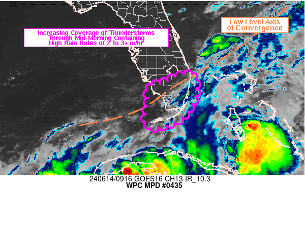
SUMMARY...Showers and thunderstorms are expected to increase
through 12Z across southern FL. Areas of training may support high
rainfall rates of 2 to 3+ in/hr, renewing flash flood concerns
over the region.

DISCUSSION...GOES East 6.9 micron imagery showed a subtle
shortwave crossing the southern FL Peninsula at 0845Z, located to
the southeast of a mid to upper-level trough axis that extended
across northern FL into the central Gulf of Mexico. Radar and
infrared satellite imagery has shown an uptick in mostly warm
topped shower activity over the past hour from near the Dry
Tortugas to the southwestern coast of the FL Peninsula where SPC
mesoanalysis data showed 500-1000 J/kg MLCAPE with decreasing
convective inhibition through 08Z along with precipitable water
values between 2.0 and 2.4 inches. Layered PW imagery showed a
similar setup to 24 hours ago in the low levels with an elongated
cyclonic circulation (~850 mb) near and northeast of 30N 80W, with
a southwestward trailing axis of convergence extending ENE to WSW
across the FL Peninsula to the south of Lake Okeechobee. Aloft,
there is a notable difference compared to yesterday which is the
approach of the positively tilted mid to upper-level trough axis
over the Gulf with modestly diffluent and divergent upper level
flow over far southern FL.

Over the next 3 to 6 hours, increasing low level confluence
focused within the 925-850 mb layer is expected to set up to the
southwest of and across southern FL as southerly flow across the
Keys meets with veering flow to the north in the wake of the
subtle shortwave impulse. Mean southwesterly steering flow will
likely support some localized training with the expected increase
in cell coverage. With existing CIN eroding from south to north
across the Everglades, the available moisture and instability is
expected to support efficient rainfall production with hourly or
subhourly rainfall of 2 to 3+ inches near and south of the
elongated low level convergence axis extending across southern
Peninsula.

Soils are still saturated throughout many areas of the region due
to extreme rainfall over the past 2-3 days of 15 to 25 inches.
While the coverage of additional heavy rainfall remains uncertain,
the expectation for increasing shower/thunderstorm coverage and
high rainfall rates warrants concern for renewed areas of flash
flooding heading through the remainder of the morning hours for
southern FL, including the Keys.

Otto

ATTN...WFO...KEY...MFL...

ATTN...RFC...SERFC...NWC...

LAT...LON   26808016 26757984 26357976 25747979 24718045
            24308166 24408205 24748209 25108204 25708193
            26198202 26328145 26638069
Download in GIS format: Shapefile
| KML
Last Updated: 520 AM EDT Fri Jun 14 2024
|


