| WPC Met Watch |
|
|
Mesoscale Precipitation Discussion: #0447 (2022) |
|
(Issued at 150 PM EDT Tue Jul 05 2022
) |
|
| MPD Selection |
|
|
|
|
|

Mesoscale Precipitation Discussion 0447
NWS Weather Prediction Center College Park MD
150 PM EDT Tue Jul 05 2022

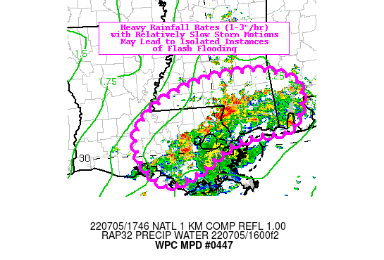
Areas affected...Southeastern LA...Southern MS/AL

Concerning...Heavy rainfall...Flash flooding possible

Valid 051747Z - 052247Z

Summary...Heavy rainfall rates (1-3"/hr) with relatively slow
storm motions may lead to localized totals of 4-6", isolated
instances of flash flooding.

Discussion...A weak, retrograding shortwave trough along the Gulf
Coast is resulting in a rather expansive area of showers and
thunderstorms across much of southeastern LA and southern MS/AL
early this afternoon. The mesoscale environment is characterized
by ML CAPE of 2000-3000 J/kg, precipitable water values of 2.2-2.4
inches (above the 90th percentile and near the max moving average,
per LIX sounding climatology), and effective bulk shear near 20
kts. While convection is expected to continue to be fairly
unorganized in this environment (relatively low shear), the
anomalous moisture content and weak steering flow (850-300 mb mean
winds near 5 kts) will allow for wide-ranging heavy rainfall rates
of 1-3"/hr. While most localities can take up to 3" of rain in an
hour, a few spots may approach totals of 4-6" in as little as 2-3
hours. An isolated instance or two of flash flooding is possible,
particularly if training occurs over more urbanized terrain.

Churchill

ATTN...WFO...JAN...LCH...LIX...MOB...

ATTN...RFC...LMRFC...SERFC...NWC...

LAT...LON   31728908 31618828 31308770 30648778 30288816
            30278877 30118964 29918994 29499066 29289133
            29649185 29969203 30499209 31049160 31449080
            31649000
Last Updated: 150 PM EDT Tue Jul 05 2022
|


