| WPC Met Watch |
|
|
Mesoscale Precipitation Discussion: #0458 (2024) |
|
(Issued at 334 AM EDT Tue Jun 18 2024
) |
|
| MPD Selection |
|
|
|
|
|

Mesoscale Precipitation Discussion 0458
NWS Weather Prediction Center College Park MD
334 AM EDT Tue Jun 18 2024

Areas affected...central SD into eastern ND and northern MN

Concerning...Heavy rainfall...Flash flooding possible

Valid 180730Z - 181330Z

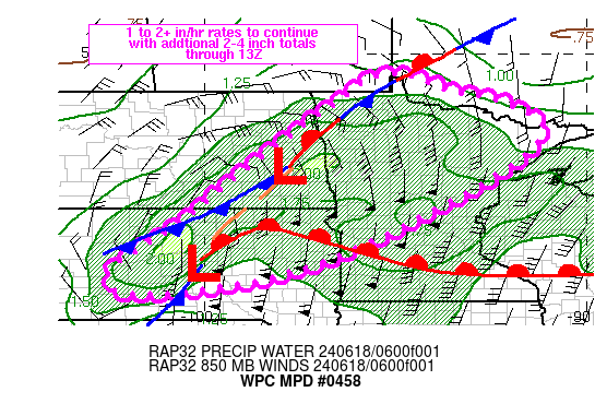
Summary...Areas of heavy rain will continue to advance through the
Dakotas into MN through sunrise. Peak rainfall rates of 1 to 2
in/hr, locally higher, are expected to produce additional but
localized 2-4 inch totals through about 13Z, which may result in
isolated to widely scattered coverage of flash flooding.

Discussion...Regional radar imagery at 07Z showed a nearly
continuous line of thunderstorms extending from eastern ND into
west-central SD. The line has generally progressing toward the
east at a steady enough pace to limit flash flood concerns but
short term areas of training have supported rainfall rates of 1-2
in/hr, locally higher, since 04Z according to MRMS. The higher
rates have primarily been focused over SD where eastward
progression of the convective line has been slower. The axis of
convection was largely elevated, positioned north of a warm front
over eastern SD within a zone of strong elevated convergence
located between 850 and 700 mb. Precipitable water values were
anomalous across the northern Plains, with 00Z area soundings
showing values near the 90th percentile but since 00Z, low level
moisture advection via a 60-70 kt 850 mb jet has further increased
moisture along with CAPE values. 07Z SPC mesoanalysis data showed
MUCAPE values ranged from 1500 J/kg over northern MN to an
impressive 4000 J/kg over northeastern SD.

As a mid-level trough over MT and western WY continues to advance
east this morning, the NE to SW oriented axis of thunderstorms
will advance through the Dakotas into MN, maintaining the threat
for 1 to 2+ in/hr rainfall rates. Synoptic scale lift in the form
of enhanced divergence and diffluence aloft will be maximized over
eastern ND into northern MN within the right entrance region of an
upper level jet max over southern Manitoba which will support
increased ascent but eastward progression of thunderstorms may
limit heavy rainfall duration. RAP guidance supports weakening of
the elevated convergence axis as an 850 mb low organizes over the
Dakotas through 12Z, with the surface and 850 mb warm front
lifting north toward the Canadian border. Through 13Z, there will
be the potential for SW to NE training where mean steering flow
aligns with the orientation of convection, perhaps better focused
across southern areas where eastward progression will be slower
compared to northern locations. These instances of training are
expected to remain short lived, but could still support short term
rainfall of 2-4 inches along with isolated to widely scattered
areas of flash flooding.

Otto

ATTN...WFO...ABR...BIS...DLH...FGF...FSD...MPX...UNR...

ATTN...RFC...MBRFC...NCRFC...NWC...

LAT...LON   49439524 49419467 48999350 48729223 48019116
            46899227 45119559 44219801 43780049 43710170
            43810236 44040249 44460233 45570060 46509950
            47609805 48339708 48799640 49229589
Download in GIS format: Shapefile
| KML
Last Updated: 334 AM EDT Tue Jun 18 2024
|


