| WPC Met Watch |
|
|
Mesoscale Precipitation Discussion: #1044 (2022) |
|
(Issued at 1248 AM EDT Wed Sep 28 2022
) |
|
| MPD Selection |
|
|
|
|
|

Mesoscale Precipitation Discussion 1044
NWS Weather Prediction Center College Park MD
1248 AM EDT Wed Sep 28 2022

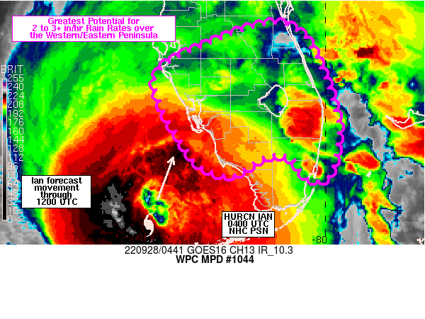
Areas affected...southwestern to east-central Florida Peninsula

Concerning...Heavy rainfall...Flash flooding possible

Valid 280447Z - 280940Z

SUMMARY...Rainfall rates of 2 to 3+ in/hr are expected to impact
portions of central/south-central Florida through 09Z with a focus
along the western and eastern Peninsula. Flash flooding will
remain possible, with the greatest potential over urban corridors
and locations that have received heavy rain over the past 24 hours.

DISCUSSION...A 04Z update from NHC placed the center of Hurricane
Ian about 15 miles north of the Dry Tortugas, tracking NNE at 9
kt. Radar imagery at 04Z showed an outer band moving north along
the eastern Peninsula, about 40 miles south of Melbourne with
another stretching from near Venice to south of Lake Okeechobee to
just west of the Miami metro. MRMS derived rainfall rates were
generally 1-2 in/hr though locally higher to the east of Fort
Pierce, just offshore, near 3 in/hr. Precipitable water values
were certainly high enough (between 2 and 2.5 inches) within the
tropical airmass to support very high rainfall rates where
training has been able to occur, but areas of training over the
past few hours has been short-lived in nature.

Over the next 3-5 hours, feeder bands coming in off of the western
Atlantic are likely to continue moving in toward the east coast
with a northward translation over time, focusing between just
south of Cape Canaveral to West Palm Beach. This is where the
greatest low level convergence is expected to set up between
generally southerly flow over southeastern Florida and more
easterly flow across the east-central Peninsula with 2 to 3 in/hr
rates at times.

The other main area expected to experience heavy rain over the
next few hours will be over the southwestern and west-central
Florida Peninsula where increasing low level convergence ahead of
the forecast track of Ian is expected to support bands of heavy
rain moving toward the coast. Rainfall rates of 1-2 in/hr are
expected.

Over southern Florida, training of heavy rain bands will be
possible where alignment of banding matches that of the
deeper-layer steering flow from the SSE. While higher
probabilities of heavy rainfall totals exist along the western and
eastern coasts, portions of the region to the south of a Fort
Myers to West Palm Beach line have received 2-6 inches of rain
over the past 24 hours and would be more susceptible to flooding
from additional training of high rainfall rates.

Otto

ATTN...WFO...MFL...MLB...TBW...

ATTN...RFC...SERFC...NWC...

LAT...LON   28208088 28048039 27538009 26607979 25907986
            25677998 25658027 26028056 26018103 25738148
            25778183 26048221 27308279 27908183
Last Updated: 1248 AM EDT Wed Sep 28 2022
|


