| WPC Met Watch |
|
|
Mesoscale Precipitation Discussion: #1107 (2023) |
|
(Issued at 445 PM EDT Wed Sep 27 2023
) |
|
| MPD Selection |
|
|
|
|
|

Mesoscale Precipitation Discussion 1107
NWS Weather Prediction Center College Park MD
445 PM EDT Wed Sep 27 2023

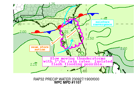
Areas affected...Northern and Central Florida Peninsula

Concerning...Heavy rainfall...Flash flooding possible

Valid 272044Z - 280230Z

Summary...Slow moving thunderstorms will expand across the Florida
Peninsula through this evening. Rainfall rates within the more
intense convection could exceed 3"/hr at times. These storms will
move slowly, producing locally more than 5 inches of rainfall,
which could lead to isolated instances of flash flooding.

Discussion...The regional radar mosaic this afternoon depicts
widespread showers and thunderstorms aligned from WSW to ENE
across the northern Florida Peninsula. These storms are developing
within impressive convergence along a slowly sinking stationary
front analyzed by WPC, and within the diffluent tail of a weak
upper level jet streak. This ascent is working across favorable
thermodynamics characterized by PWs of 2.2-2.4 inches as analyzed
by GPS and measured by the 15Z KXMR sounding, which is above the
daily record for the site. Additionally, a ribbon of SBCAPE
exceeding 2500 J/kg is analyzed by the SPC RAP, with regional
forecast soundings measuring deep warm cloud depths above 14,000
ft, indicative of efficient warm rain processes. These warm rain
processes are being observed via radar-estimated rain rates
reaching 2.5+"/hr on KMLB, resulting in modest FLASH response
already.

The high-res guidance is in very good agreement, at least on a
broad scale, with the evolution through this evening. While there
is some north-south placement uncertainty in the axis of heaviest
rainfall, there is a clear signal among the guidance and
associated ensemble systems that heavy rainfall will envelop much
of the northern and central peninsula. As the boundary sinks
slowly southward and the jet streak remains over the Mid-Atlantic,
plentiful ascent into the robust thermodynamics will result in
continued convective development. Effective bulk shear will remain
minimal, so pulse-type storms are expected to be dominant, but
resultant outflows and storm mergers could additionally lead to
more widespread development. These storms will all have the
potential to produce 3"/hr rain rates as progged by HREF rain-rate
probabilities reaching 20-25%, and supported by the HRRR 15-min
product suggesting 0.75-1" of rainfall. Despite the pulse nature
of these storms which should limit their overall lifespans, very
slow motions on 0-6km mean winds of just 5 kts, will allow for
multiple rounds of storms in some areas. This has a high
likelihood of producing more than 3" of rain south of the front,
with local totals above 5" possible as reflected by both HREF and
RRFS TL probabilities.

FFG remains quite high across the Peninsula at 3"/1hr and 3-4"/3
hrs, so FFG exceedance probabilities are modest. However, recent
rainfall measured by the NSSL 24-hr QPE has been as much as 2-4"
in some areas, which has helped more impressively saturate the top
10cm soils according to NASA SPoRT. The consistent signal for
heavy rain among the various high-res suggests that where these
higher totals can occur, especially over urban areas or soils
primed from yesterday's rain, isolated instances of flash flooding
could occur.


Weiss

ATTN...WFO...JAX...MLB...TBW...

ATTN...RFC...SERFC...NWC...

LAT...LON   30538135 29988112 28988075 28448053 27918056
            27688100 27448156 27338219 27348257 27788276
            28348267 28768273 29388288 29978239 30378174
Last Updated: 445 PM EDT Wed Sep 27 2023
|


