| WPC Met Watch |
|
|
Mesoscale Precipitation Discussion: #1129 (2022) |
|
(Issued at 932 AM EST Thu Nov 24 2022
) |
|
| MPD Selection |
|
|
|
|
|

Mesoscale Precipitation Discussion 1129
NWS Weather Prediction Center College Park MD
932 AM EST Thu Nov 24 2022

Areas affected...Central to Northeast Texas...

Concerning...Heavy rainfall...Flash flooding possible

Valid 241431Z - 241930Z

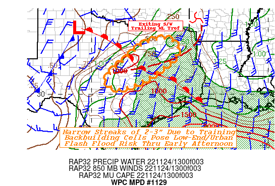
SUMMARY...Potential for training cells and narrow streaks of 2-3"
totals may pose possible low-end/urban flash flooding this morning
into early afternoon.

DISCUSSION...GOES-E 10.3um EIR loop denotes a cluster of expanding
cooler thunderstorm tops across central Texas, with increasing
lightning coverage/intensity.  WV suite and RAP analysis winds
suggest these cells reside at the col in flow between the exiting
shortwave over SW AR and the shortwave ridging taking place across
W TX as the deeper closed low drops in carving out a favorable
diffluent upper level environment across much of E TX later today.
 This trailing 700-500mb trof axis is oriented SW to NE aligned
very well will a pre-frontal low level convergence/confluence zone
(25-35kts at 850mb), resulting in a tightening gradient of
increased deep layer moisture and unstable air.  Sfc Tds are
starting to increase in the southerly flow with a few mid to upper
60s encroaching on this convergence zone.  While moisture is still
not peaking, it is starting to reach favorable values of 1.3-1.5"
of total PWats.  Given 1000-1250 J/kg of MUCAPE and mid-level RH
values over 70% along with the moisture convergence, the cells are
fairly efficient in rainfall production with local observations
denoting quick (15-30 minute) totals of .5-1" across Coryell
county already.

These cells are resulting in low (2-3 cfs/km2 responses on MRMS
FLASH Unit Streamflow and suggests any individual cell is not
likely to pose more than low-end flooding.  However, given the
regime for continued south and south-southeasterly moisture return
and favorable environment for training and upstream redevelopment
along this gradient there is a low-end potential for streaks of
enhanced rainfall totals.  Additionally, given some 2 week
precipitation anomalies and increasingly dormant ground
conditions, FFG values of 1.5-2"/hr and 2-3" along and west of the
I-35 corridor may be more susceptible for increased run-off and a
low-end localized flash flooding concern mainly in urban centers
through the morning into early afternoon.  MPD area of concern was
pulled downstream into Northeast TX given some pockets of modest
rainfall over night (1-2" totals), perhaps increasing potential
for the training cells to pose a low risk there as well.

Gallina

ATTN...WFO...EWX...FWD...SHV...SJT...

ATTN...RFC...WGRFC...NWC...

LAT...LON   33169606 32929526 32289520 31629586 30829702
            30539771 30329855 30749917 31179895 32139789
            32819711
Last Updated: 932 AM EST Thu Nov 24 2022
|


