| WPC Met Watch |
|
|
Mesoscale Precipitation Discussion: #0403 (2022) |
|
(Issued at 1154 PM EDT Fri Jun 24 2022
) |
|
| MPD Selection |
|
|
|
|
|

Mesoscale Precipitation Discussion 0403
NWS Weather Prediction Center College Park MD
1154 PM EDT Fri Jun 24 2022

Areas affected...Far Southern Minnesota...Northern
Iowa...Southeast South Dakota...Eastern Nebraska

Concerning...Heavy rainfall...Flash flooding possible

Valid 250350Z - 250930Z

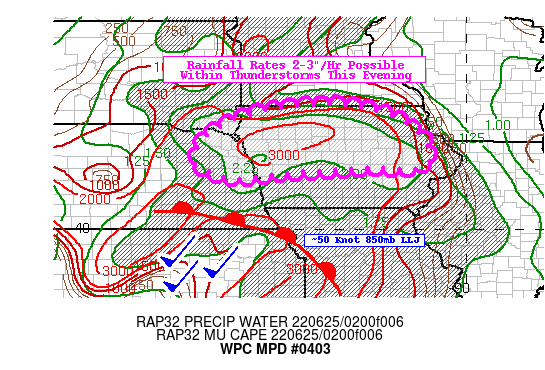
SUMMARY...Developing organized lines of thunderstorms containing
Excessive Rainfall rates >2"/hr tonight may lead to areas of flash
flooding, especially where training convection transpires.

DISCUSSION...Latest surface analysis depicts a surface warm front
inching north through the Central Plains while a strengthening LLJ
takes shape in response to pressure falls ahead of an approaching
upper trough to the northwest. The LLJ will bring about a surge in
850-700mb moisture flux. This is also identifiable in the dew
points aloft, as the latest RAP forecast shows a swath of >8C dew
points at 700mb lifting through eastern Nebraska and northern Iowa
by ~06Z. PWs will rise above 2.0" overnight with some areas
potentially approaching 2.25", especially where the most intense
convection takes shape. This is also coinciding at the nose of the
850mb jet, where it will be positioned orthogonally to the warm
front at the surface. This kind of moisture advection will also
result in rising MUCAPE values, which the HRRR suggests could top
3,000 J/kg just before the line of storms begin to take shape
around midnight CDT.

In addition to the favorable thermodynamic parameters, vertical
wind shear and storm relative helicity will be on the increase as
well. Between 06-08Z, the most recent RAP suggests effective bulk
shear will be up to ~40 knots and effective SRH up to 400 m2/s2.
These kind of modeled hodographs across the area do support
organized, congealing convection that combined with LCL-EL
relative humidity values >80% would support efficient warm rain
processes (given warm cloud layers of ~12kft). As the LLJ
continues to intersect the warm front, backbuilding areas of
convection could lead to training, primarily in north-central and
eastern Iowa where 850-300mb mean flow does run quasi-parallel to
the warm front.

The one limiting factor of note is antecedent soil moisture
conditions. Much of the area according to NASA SPoRT-LIS's 0-40cm
soil moisture percentiles are below 20%, and some portions of
northeast Nebraska and western Iowa are in severe drought. Still,
the concern is for hourly rainfall rates potentially as high as
3"/hr within the more vigorous thunderstorms. Current 3-hr FFGs
are as low as 2", which the latest 00Z HREF indicates as much as a
50% chance of 3-hr QPF exceeding 3-hr FFGs between 06-09Z. Should
this transpire, rapid runoff could still lead to localized flash
flood concerns despite the initially drier soils. Farther east in
central Iowa, soils are still on the drier side but not quite as
dry. It will be here where flash flooding has the best chance of
occurring, especially in urbanized locations where a greater
concentration of hydrophobic surfaces exist. This could result in
fast rising nearby creeks and streams as well.

Mullinax

ATTN...WFO...ARX...DMX...DVN...FSD...MPX...OAX...

ATTN...RFC...MBRFC...NCRFC...NWC...

LAT...LON   43579388 43089182 42159102 41749143 41769284
            41609511 41459674 41879775 42629748 43279618
Last Updated: 1154 PM EDT Fri Jun 24 2022
|


