| WPC Met Watch |
|
|
Mesoscale Precipitation Discussion: #0067 (2019) |
|
(Issued at 927 AM EST Sat Feb 23 2019
) |
|
| MPD Selection |
|
|
|
|
|

Mesoscale Precipitation Discussion 0067
NWS Weather Prediction Center College Park MD
927 AM EST Sat Feb 23 2019

Areas affected...Southern AR...Northern LA...Ext Northwest MS...

Concerning...Heavy rainfall...Flash flooding likely

Valid 231430Z - 231930Z

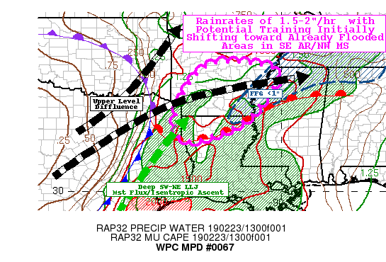
SUMMARY...Developing pre-cold front convective line, advancing
toward compromised/flooded ground condtions across SE AR/NE LA/ext
NW MS.  Short-term cross track/repeat convection pose isolated
threat initially further west.

DISCUSSION...Very strong, negative tilt closed low ejecting into
the Southern Plains is enhancing wind fields/dynamic forcing
across the lower Red River region.  Current surface analysis
depicts a warm front across NE TX, lifting rapidly up the
Mississippi River Valley into central MS.  This warm front
intersects with the cold front near JXI in NE TX.  South of the
boundary near zero Td depression with Td values in the upper 60s
to lower 70s is directing from SW to NNE through a great depth
from SFC to 7H, supporting strong moisture convergence and
isentropic ascent north of the front.  This has sparked a line of
fairly deep convection with tops to -65C in clear IR channel, with
fairly frequent lightning.  Total PWat values of 1.5" and flux
convergence through this vertical depth is becoming supportive of
1.5-2"/hr rates at this time.  Currently, WV suite depicts the
strong jet, but also the branching/split of the polar jet and
subtropical jet axis just north of the main convective area.
Still, this supports very good outflow/UVVs with both speed
divergence as well as modest diffluence in the area of concern.
At this time, the low level flow is fairly unidirectional through
a deep cloud baring layer (up to 7H) to support internal SSW to
NNE convective cores for some training, and with strength of the
925-850mb (40kt) inflow, supports upstream redevelopment.  As such
there is potential (even though cell motions are fast) for some
compounded totals of 1.5-2" in an hour or less across SW AR/N LA.
While FFG values are not particularly reliable (having rebounding
perhaps too quickly in a winter-time saturated environment) they
are still higher to suggest these totals pose isolated to
scattered flash flooding potential over the next few hours in SW
AR.

As the subtropical jet and polar jet further bifurcate in the next
few hours, the steering flow is expected to angle less favorably
for training with increased easterly movement.  However, these
cells will start to propagate into areas of compromised soil or
even currently flooding locations across SE AR into NW MS.  FFG
values below 1" across the region are likely to be exceeded even
with fairly fast moving convection as rates of 1.5-2"/hr remain
likely, so even 1" totals would reactivate flash flooding
conditions toward late morning/early afternoon.  As such flash
flooding is considered likely.

Gallina

ATTN...WFO...JAN...LZK...MEG...SHV...

ATTN...RFC...ABRFC...LMRFC...WGRFC...

LAT...LON   35169262 35069073 34659015 33649077 32859150
            32319266 32069356 32159410 32559427 33079423
            34419366
Last Updated: 927 AM EST Sat Feb 23 2019
|


