| WPC Met Watch |
|
|
Mesoscale Precipitation Discussion: #0698 (2018) |
|
(Issued at 853 AM EDT Mon Aug 20 2018
) |
|
| MPD Selection |
|
|
|
|
|

Mesoscale Precipitation Discussion 0698
NWS Weather Prediction Center College Park MD
853 AM EDT Mon Aug 20 2018

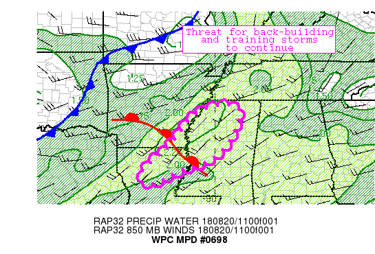
Areas affected...Southeastern AR...Northern MS...Northeastern LA

Concerning...Heavy rainfall...Flash flooding possible

Valid 201250Z - 201850Z

Summary...Ingredients for back-building/training convection are
expected to remain in place.  Additional flash-flooding is
possible.

Discussion...Latest mesoanalysis shows southwesterly flow
supporting a plume of deep moisture (PWs 2 to 2.4 inches) across a
weak warm front extending southeast well out ahead of a
slow-moving cold front that extends from the mid-Mississippi
valley back into the southern plains.  Ahead of a slow-moving low,
the latest RAP shows 850mb winds remaining 20-30kts from the
southwest, with comparable to weaker flow aloft -- supporting the
potential for back-building/training convection well into the
morning hours.  The RAP shows this deep moisture, with slow
propagation vectors, along with increasing instability through the
morning hours.  Runoff concerns across this area are heightened by
recent heavy rains -- with the most recent NSSL QPE showing 24-hr
estimates as high as 3-6 inches along the Arkansas/Mississippi
border.  Recent runs of the HRRR have been slow to recognize the
ongoing trends, particularly along the southern extent of the
ongoing convection, where GOES imagery shows cooling cloud tops
and where KLZK radar continues to show rainfall rates of 1.5-2
inches.

Pereira

ATTN...WFO...JAN...LCH...LZK...MEG...SHV...

ATTN...RFC...LMRFC...SERFC...

LAT...LON   34808967 34438893 32798979 32089141 31489277
            32039297 33229176 34389083
Last Updated: 853 AM EDT Mon Aug 20 2018
|


