| WPC Met Watch |
|
|
Mesoscale Precipitation Discussion: #0173 |
|
(Issued at 1149 PM EDT Thu Apr 25 2024
) |
|
| MPD Selection |
|
|
|
|
|

Mesoscale Precipitation Discussion 0173
NWS Weather Prediction Center College Park MD
1149 PM EDT Thu Apr 25 2024

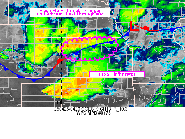
Areas affected...Far Northwest to North-Central KS...Southern NE

Concerning...Heavy rainfall...Flash flooding possible

Valid 260348Z - 260815Z

SUMMARY...The threat for some isolated areas of flash flooding
will continue over the next few hours from locally repeating areas
of heavy showers and thunderstorms.

DISCUSSION...The latest radar and satellite imagery continues to
show an axis of deep convection across areas of far northwest to
north-central KS and into southern NE. Over the last 1 to 2 hours,
the convection has been tending to align in a more parallel
fashion to north of a quasi-stationary front.

There is still a conducive environment for strong convection to
persist over the next few hours given a nocturnally enhanced
southerly low-level jet of 50+ kts overrunning the front and with
moderate elevated buoyancy characterized by MUCAPE values of 1500
to 2500 J/kg. Furthermore, the flow aloft is very divergent as
seen in GOES-E satellite imagery, and this deeper layer ascent in
conjunction with the favorable thermodynamic environment, strong
shear parameters, and the aforementioned low-level jet should
sustain the threat of organized convection for at least the next 3
to 5 hours.

The more organized storm clusters should continue to produce
rainfall rates that could reach 1.5"/hour. The PW environment is
not overly high with values around 1.25 inches, but the level of
deep convection and persistence of the low-level jet energy should
still favor a notable heavy rainfall threat in the short-term.

This will especially be the case where some of these storm
clusters tend to repeat or train over the same area, and there
will be concerns for this especially over parts of far southern NE
based on the latest satellite and radar trends.

Additional rainfall totals of as much as 3 to 4 inches can be
expected over the next few hours. This will continue to drive at
least an isolated threat of flash flooding as a result.

Orrison

ATTN...WFO...GID...GLD...LBF...OAX...

ATTN...RFC...MBRFC...NWC...

LAT...LON   41489725 41219676 40799665 40319712 39869879
            39639998 39530062 39470155 39670197 40320168
            40760083 41109962 41439819
Download in GIS format: Shapefile
| KML
Last Updated: 1149 PM EDT Thu Apr 25 2024
|


