|
0315 UTC |
|
0715 UTC |
|
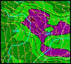
NAM 0300 UTC original CMF vectors |
|
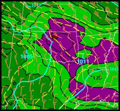
NAM 0300 UTC revised method vectors |
|
0415 UTC |
|
Note how slow moving the MCS moves between 0315Z and 0715Z. The revised method predicted 20 to 25 kt movement to the east-southeast while the original method predicted 10 to 15 kts. |
|
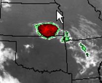
Note how the MCS radar signature took on a configuration with the brightest radar echoes on the western edge of the MCS and that new cells kept forming over Kansas where the initial convection started for a prolonged period. The original vector method used the most active beta elements to track the speed of the MCS. During this case even though individual cells were moving southeastward at around 25 kts, the MCS only moved around 10 knots. Also, the brightest clouds were on the edge of the convection where the strongest instability and low level convergence were located. It had the look of a leading stratiform type convective system or a cross between a training line-adjoining stratiform and back building type of MCS. |
|
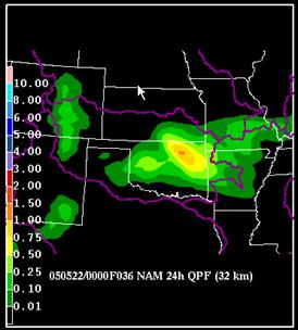
12-36 hr accumulated precipitation forecast from the NAM |
|
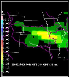
12-36 hr accumulated precipitation forecast from the GFS |
|
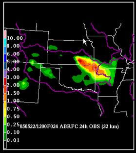
24 hr accumulated precipitation for the same period |
|
Backward propagating (upshear propagating) systems often produce a heavier core of rainfall than the models. In this case, both the NAM and GFS underpredicted the rainfall associated with the MCS. The GFS had a better forecast of the axis of heaviest rainfall but it only predicted .50 inches. The 1.00 inch or greater area extended from southeastern Kansas into northwestern Arkansas. |
|
Neither model predicted heavy enough rainfall during this event. The two small observed 2.00 greater areas on the analysis illustrate how small scale the core of heaviest rainfall associated with an MCS can be. |
|
The GFS often forecasts its rainfall axis to the north of the NAM. Observations of the HPC forecasters is that if it has a bias, it is to be too far north with its axis. However, for this case, it’s more northerly axis was correct. |
|
The NAM does not have a consistent northward or southward bias. However, the model does have bias of not predicting heavy enough rainfall with convection because it tends to overpredict light rainfall which releases the instability too early. The NAM also sometimes will predict the rainfall axis too far south when strong instability (high CAPE) is present along a front where there is also strong CIN. That appears to be what happened in this case. |
|
Exercise 2 recap |