|
Maddox et al. (1979 and 1980) studied 150 heavy rainfall events and identified three primary types of mesoscale convective systems as often producing excessive rain. Two (Meso-High and Frontal types) were primarily mesoscale phenomena; the other (Synoptic) was driven by synoptic forcing but still often occurred on the Meso-a scale instead of the synoptic scale. A fourth type, the cyclonic circulation system, was identified by Spayd and Scofield (1982). |
|
A number of features were common to many of the excessive rainfall events studied by Maddox and his colleagues. They state:
1). Most flash floods were associated with convective storms. 2). Storms occurred where surface dew points were high. 3). Relatively high moisture contents were present through a deep tropospheric layer. 4). Weak to moderate vertical wind shear was present through the cloud depth. 5). Convective storms and/or cells repeatedly moved over the same area. 6). A weak, mid-tropospheric, Meso-a scale trough helped to trigger and focus the storms. 7). The storm position was very near the mid-tropospheric, large-scale ridge position. 8). Storms often occurred during the nighttime hours. Remember the bulk of the Maddox MCCs were located in the Plains |
|
Numerical models still often do not forecast explicitly forecast these mesoscale type of extreme rainfall events, but often show the synoptic pattern which is associated with their development. This is where conceptual models come into play enabling a forecaster to identify which synoptic features are typically present when mesoscale heavy rainfall events develop. However, as noted earlier, when using pattern recognition or conceptual models it is imperative to still apply an ingredients based methodology to forecasts as try to aniticpate whether the convective system will be a forward or backward propagating one. |
|
Synoptic type heavy rainfall events.
Synoptic type heavy rain events, Maddox et al. (1979), comprised about 20 percent of the flash flood events studied by Maddox and his colleagues. Synoptic type events are most common during the spring and early summer and again in fall and early winter. In synoptic type flash floods, a strong 500-hPa trough is usually moving slowly eastward or northeastward. A weak upper-level shortwave often lifts northeastward ahead of the main trough and weakens. Most of the associated height falls shift more northeastward then eastward. Therefore, any surface low lifts northeastward and the trailing front slows or stalls as it becomes parallel to the upper flow. Fronts attending these events are usually oriented southwest to northeast, but Maddox noted a few that extended west to east. |

|
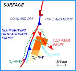
The typical surface pattern associated with synoptic type flash floods is shown above (top left). The yellow shading is where surface dewpoints are 70oF or higher. The boxes represent the flash flood threat area. Note that the heavy rains usually occur in the warm sector but that the area may be located near an old frontal boundary or dewpoint discontinuity. The front is usually slow moving and is aligned parallel to the mean flow which promotes training of cells.
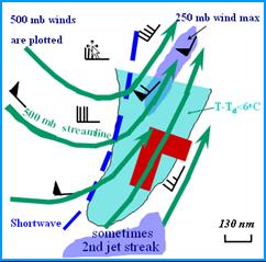
Typical 500-hPa stream line pattern and 250-hPa wind maxima position during synoptic events is illustrated on the top left panel. A strong 500-hPa trough is usually located to the west. Often an initial shortwave lifts northeast and another one drops into the trough holding the southern portion of the trough almost stationary. The second shortwave often induces a weak frontal wave on the front.
|
|
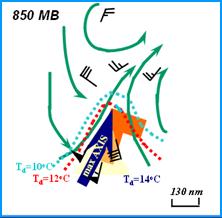
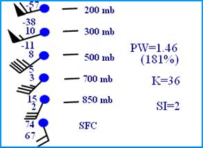
Strong winds are typically present at 850 mb and the winds often are confluent. There is often tongue of 850 dewpoints of 15C or greater with the threat area being located just north of the dewpoint maximum. In essence the area of maximum rainfall potential is located just north of a Θe ridge. The figure above (right hand side) is a composite of the wind, temperature and dewpoints depressions at various levels. The number 2 plotted below the 15 at 850 mb indicates that the average 850 dewpoint temperature was 13oC. However, the temperature and dewpoint plotted at the surface on the figure are given in oF. Precipitable water values are typically around 1.46” or about 181% percent of normal. Remember that precipitable water is the integrated moisture through the column and is not the moisture at any one level. On the workstations, model forecasts of precipitable water is often plotted with 850-hPa winds.
There are several important points to make about synoptic type events. First, while the winds aloft are typically stronger than found for other type of event, the mean winds in the cloud bearing layer are almost always parallel to frontal boundary. Cells within the front track northward or northeastward with the mean flow only to be replaced by new cells that form in axis of low level convergence associated with the front. The movement of the band of convection is often linked to the movement of the forcing associated with the mid level trough.
|


|
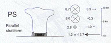
The Maddox synoptic type flash flood is usually associated with a subset of the Parker and Johnson Parallel stratiform (PS) type of MCSs. The size of the circle with the “x” inside it on the figure above is the strength of the winds parallel to the axis of convection or line. The arrows at right are the line perpendicular winds. |
|
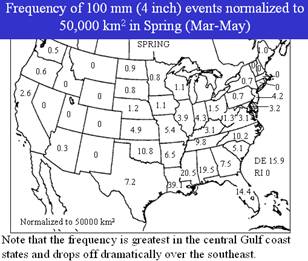
The synoptic archtype can occur during any time of year but is most common during the transition seasons from late winter to early summer and from fall into early winter. Synoptic type events are usually associated with strong 500-hPa troughs that are lifting to the northeast. There is a distinct maximum to 4 inch or greater rainfall events across the Gulf Coast region from late winter into the spring (figure below left). |
|
As early a 1972, Smith and Younkin (1972) showed that relationship of heavy rain to the jet stream with a digging polar jet. Maddox (1979) states that the cases Smith and Younkin investigated were probably synoptic type heavy rain events. The 1972 study never mentioned the concept of jet streaks. However, the favored position they found for the heaviest rain however is in a favorable location that would allow strong vertical motion to develop. Their position would allow the exit region of the jet max swinging around the base of the trough and the entrance region of the jet streak developing on the eastern side of a trough to enhance the vertical motions. A similar process has been described for heavy snowstorms by Uccellini and Kocin (1987). |
|
The threat area (red boxes) is often along the right entrance region of an upper level jet streak and is sometime in the region where the entrance region of the polar jet and exit region of the subtropical jet are juxtaposed (Beleville and Stewart, 1983). |
|
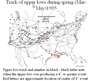
The period Mar-May 1995 was a very active period of heavy to excessive rainfall from Texas eastward into western Alabama. During this period the track of 500-hPA lows was generally from the southeast across Colorado and then northeastward towards the Great Lakes region. Such a track usually means that the strongest height fall are north of the Gulf coast region. The track also implies that the mean trough remains well west of the high precipitation area. |
|
Original Maddox et al. MCS archtypes associated with flash flooding |