24 Hr QPF ending at 12 UTC on:
WPC Forecast (24hr)
|
Observed(MRMS-prelim)
|
Objects (0.50 inch)
|
CONUS Daily CSI Ranking:
wpcblend...0.381
ukmet......0.374
rrfse1tlbm..0.367
wpc........0.366
ndfd.......0.366
hrefbm.....0.35
nbm.......0.342
ecmwfaifs..0.34
gfs........0.323
ecmwf......0.322
cmc_reg....0.318
nbm_07Z....0.317
mmebc......0.315
rrfsa.....0.29
cmc........0.29
nam12......0.27
hrrr.......0.266
fv3lam.....0.262
namnest....0.249
arw2.......0.241
arw........0.194
nbmp_07Z...-999
nbmp.......-999
|
Background
The Method for Object-Based Diagnostic Evaluation (MODE) is an object-oriented
verification technique that is part of the
Model Evaluation Tools (MET) verification package developed by the
Developmental Testbed Center (DTC)
. Object-oriented verification methods have been developed in an attempt to better
account for spatial discontinuities between forecast and observed precipitation as well
as provide more specific information about forecast quality than can be obtained from
traditional verification measures (threat score, bias, etc.) alone. These techniques
are considered particularly useful for evaluating high resolution model guidance.
Traditional verification methods often struggle to accurately assess the performance of
high resolution models since even small spatial errors can result in the forecast being
penalized twice (once for missing the observed precipitation and a second time for giving
a false alarm). The goal of the MODE tool is to evaluate forecast quality in a manner
similar to a forecaster completing a subjective forecast evaluation.
How it Works
MODE identifies precipitation objects in both the forecast and observed fields at a
number of different thresholds. It then uses a variety of object characteristics (ex:
distance between objects, size of objects, angle of orientation, etc.) to determine the
degree of similarity between objects in the forecast and observed fields. Objects that
are found to be similar to one another are considered “matched”, while those that are
not similar are considered “unmatched”. Unmatched objects in the forecast
field are equivalent to a false alarm. Unmatched objects in the observed field are
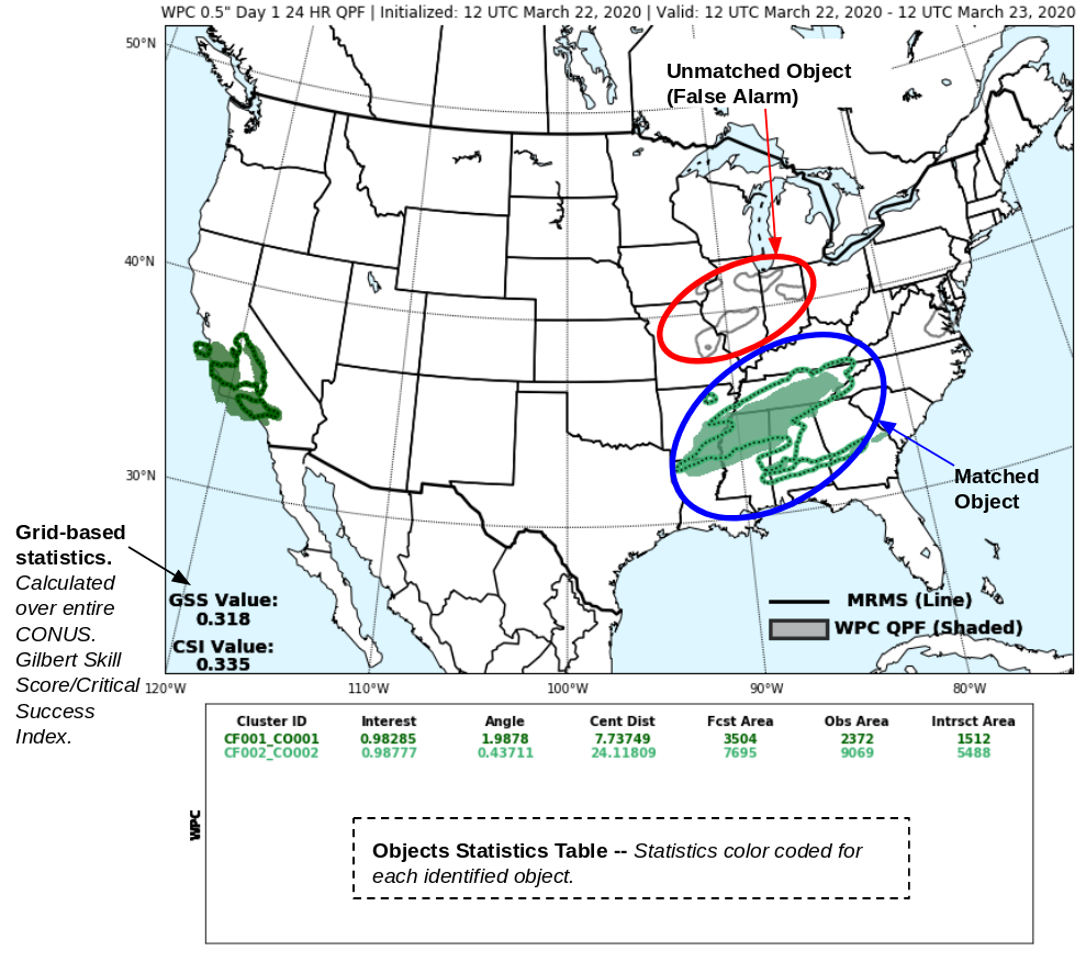
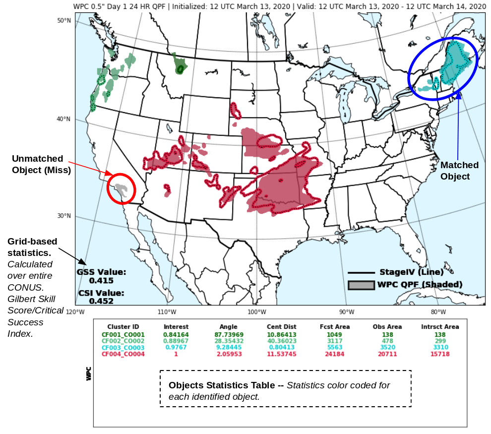
equivalent to a miss. Examples of the graphical verification output produced by MODE
are below. Matched objects are indicated in the same color in both the forecast and
the observed fields. In the cases below, the colored objects are matched with one another.
Unmatched objects are always displayed as gray. Gray contours like in the example on the left
represent an unmatched forecast objects (false alarm) and gray shaded areas like in the example
on the right in California represent an unmatched observation object (miss).
In addition to the graphical output, MODE also provides statistical information for each
matched object. This information includes a parameter called the interest value, which is
an overall measure of similarity between objects in the forecast and observed fields. The
interest value ranges from 0 to 1, with a value of 0.70 required for objects to be considered
matched. In addition to the interest value, MODE also provides information about the following: centroid
distance: the distance between the center of a forecast object and the center of the corresponding
observed object (smaller is good); angle: for non-circular objects gives a measure of orientation
errors (smaller is good); forecast area: the number of grid points enclosed in a forecast object;
observation area: the number of grid points enclosed in the analysis object; intersect area: the number of grid
points in both the forecast and the observation objects. These stats can be found in the table below the image
and are color coded to match each object that is identified.
MODE at WPC
MODE verification is available for Day 1, Day 2, and Day 3 forecasts of 24 hr precipitation valid
at 1200 UTC. The preliminary verification uses
MRMS
radar-derived precipitation observations and is available the same day. The final verification uses
Stage IV precipitation
observations and is available two days later. In addition to the WPC forecast, verification is also
available for model forecasts from the GFS, ECMWF, NBMv3.2, NAM 12km, CMC, UKMET, NAM CONUS Nest, HRRR, HREF Blended Mean, GEM Regional, the
NCEP high resolution window runs (ARW, ARW Member2, and NMMB), and a WPC-generated multi-model ensemble bias corrected
(MMEBC; see presentations
MMEBC QPF Part I and
MMEBC QPF Part II).
All forecasts and observations are re-gridded to a 5 km grid prior to verification. In order
to compare WPC forecasts to the model data available at the time they were generated, the forecast
lead times are offset such that the 24 hr (Day 1), 48 hr (Day 2), and 72 hr (Day 3) WPC forecasts are
compared to the 36 hr, 60 hr, and 84 hr model forecasts, respectively. Some select MODE settings can be found here:
MODE Settings
Additional References
Davis, C., B. Brown, and R. Bullock, 2006: Object-based verification of precipitation
forecasts. Part I: Methodology and application to mesoscale rain areas. Mon. Wea. Rev.,
134, 1772-1784.
Davis, C., B. Brown, and R. Bullock, 2006: Object-based verification of precipitation
forecasts. Part II: Application to convective rain systems. Mon. Wea. Rev., 134,
1785-1795.
Model Evaluation Tools (MET) was developed at the National Center for Atmospheric Research
(NCAR) through grants from the United States Air Force Weather Agency (AFWA) and the National
Oceanic and Atmospheric Administration (NOAA). NCAR is sponsored by the United States National
Science Foundation.