Product Information
|
and others interested in the details of WPC operations. |
WPC MissionThe Weather Prediction Center (WPC) provides forecast, guidance, and analysis products and services to support the daily public forecasting activities of the NWS and its customers, and provides tailored support to other government agencies in emergency and special situations. We are here to assist and be a resource for you. We are available 24 hours a day, 7 days a week to alert you to the potential for significant weather events dealing with heavy rainfall or snowfall, to discuss quantitative precipitation forecasts and model differences relating to general weather and precipitation forecasts, and to provide forecast guidance into the medium range period (days 3 to 7). Most of the forecasters at the WPC have extensive experience at quantitative precipitation, heavy snow and medium range forecasting. |
Quantitative Precipitation Forecasts (QPFs)Forecasters at the WPC [and its predecessor organizations, NMC's Meteorological Operations Division, Heavy Precipitation Branch (HPB) and the Quantitative Precipitation Branch (QPB)] have been issuing QPFs since 1960. All QPFs incorporate the latest surface and upper air analyses, radar data, satellite data, and model guidance from the NAM, NGM, GFS and RUC displayed on N-AWIPS workstations. WPC also works in conjunction with meteorologists in NESDIS's Synoptic Analysis Branch (SAB) to obtain information regarding satellite trends, precipitation and moisture availability estimates. This co-location and collaboration between SAB and WPC is bureaucratically known as the National Precipitation Prediction Unit (NPPU). A Senior Branch (lead) Forecaster (SBF) is on shift at all times. He or she is responsible for producing the day 1 24-hour precipitation forecasts, coordination of all WPC products (both internally and with other NWS offices), and center administrative operations after business hours. In addition to normal duties, the SBF participates in the East Coast winter storm and NHC hurricane conference calls regarding heavy precipitation, occasional unscheduled FEMA conference calls and numerous media interviews. |
24 Hour QPFs
Isohyets of expected basin average rainfall of 0.01, 0.25 inch, 0.50 inch, 1 inch, and 1.50 inch and greater (in inch increments) are drawn for three consecutive (Days 1-3) 24 hour forecast periods ending at 0000Z (for issuance times between 1815Z and 2215Z) and 1200Z (for issuance times between 0615Z and 1015Z). An electronically generated bulletin, which describes the location of the forecast isohyets using latitude and longitude points, is transmitted at the end of the QPF discussion for the Day 1 through Day 3 final products. Example:
The first field is the value of the contour (in
this case...0.25" or 0.50"). The following fields are the latitude/longitude pairs
for the contour. The first three digits of the pair are the degrees of
latitude (in tenths of degrees North latitude). The last three digits of
the pair are the degrees of longitude (in tenths of degrees West longitude).
If the fourth digit is less than 5, a leading
"1" is added to indicate longitudes greater than or equal to 100° W.
From the above message, the following table gives the decoded lat/long
pairs:
|
6 Hourly QPFs
These forecasts depict isohyets of accumulated precipitation of 0.01, 0.25, 0.50, 1 inch and greater (in 1 inch increments) expected in each six hour period. The SBF generates the six-hourly forecasts for Day 1, including the 00-06 hour update (91e). Another meteorologist prepares the Day 2 and Day 3 six hourly products during 2 shifts per day (~9am-5pm/9pm-5am EST), issuing QPFs for eight consecutive six-hourly periods ending on synoptic hours. As of June 22, 2010, WPC began issuing two additional 6-hour QPFs for the Day 3½ period once daily at 1000 UTC (5am EST). | ||||||||||||||||||||||||||||||||||||||||
48-Hour Day 4-5 and 5-Day Total QPFsThe Day 4-5 Quantitative Precipitation Forecast (QPF) products are prepared by our medium-range forecasters twice per day, once at 7:00 AM EDT/EST (11Z/12Z) and again around 1:00 PM EDT/EST (17Z/18Z).Both forecasts are valid from the beginning of Day 4 through the end of Day 5, with the later issuance offset by 12 hours. For example, a forecast prepared at 7:00 AM EDT/EST September 2, 2004 would be valid for the 48 hour period from 12Z September 5, 2004 through 12Z September 7, 2004. The forecast prepared at 1:00 PM EDT/EST September 2, 2004 would be valid from 00Z September 6, 2004 through 00Z September 8, 2004. The 5-Day Quantitative Precipitation Forecast (QPF) products are created by adding WPC's 6-hour QPFs for Days 1-3 (a total of 12 6-hour periods) to a 48-hour forecast for Days 4-5 prepared by our medium-range forecasters. This forecast is issued twice per day, once at 7:00 AM EDT/EST (11Z/12Z) and again at 7:00 PM EST/EDT (23Z/00Z). Both forecasts are valid from the beginning of Day 1 through the end of Day 5, with the later issuance offset by 12 hours. For example, a forecast prepared at 7:00 AM EDT/EST September 2, 2004 would be valid for the 120 hour period from 12Z September 2, 2004 through 12Z September 7, 2004. The forecast prepared at 7:00 PM EST/EDT September 2, 2004 would be valid from 00Z September 3, 2004 through 00Z September 8, 2004. |
Excessive Rainfall Potential
|
On April 9, 2013, WPC began providing short term guidance during heavy rain events leading to a threat of flash flooding to the National Weather Service (NWS) Weather Forecast Offices (WFOs), River Forecast Centers (RFCs), the media, emergency managers and interested partners. Guidance is given in the form of Mesoscale Precipitation Discussions (MPDs), that are ideally issued 1-6 hours ahead of time, averaging an area equal to roughly half the size of the state of Kansas. Each MPD consists of a graphic indicating the area of concern and any pertinent meteorological features as well as a brief text discussion focused on the mesoscale features supporting the anticipated heavy rainfall. The potential for flash flooding within the area of concern will be highlighted by one of three headlines:
FLASH FLOODING LIKELY High confidence exists that environmental conditions are favorable, or will become favorable, for heavy rainfall that will result in flash flooding.
FLASH FLOODING POSSIBLE Environmental conditions are favorable, or will become favorable, for heavy rainfall, but there are questions about how the event will evolve and/or whether flash flooding will occur.
FLASH FLOODING UNLIKELY High confidence exists that environmental conditions are unfavorable, or will become unfavorable, for heavy rainfall that will result in flash flooding. (typically issued toward the end of an event)
While flash flooding is caused by a variety of factors (e.g., intense rainfall, dam failure, ice jams), WPC's Metwatch desk will only focus on flash floods triggered by intense rainfall that occur over a sufficient areal coverage. Localized flash flooding is not considered.
The MPD appears under WMO Header: AWUS01 KWNH
and AWIPS header: KWNH FFGMPD
QPF Forecast Verification:6-hourly precipitation forecasts are verified using a point (station) method while 24 hour forecasts are verified using an areal method. Current graphs depicting WPC verification scores are available on the WPC Verification page. For more details about the verification of WPC precipitation forecasts, read the article by Olson, Junker and Korty in Weather and Forecasting.Volume 10, 1995, pgs. 498-511. |
Medium Range/Extended (3-7 days)
|
In addition to the graphical forecasts, the forecasters prepare two daily written discussions. They highlight medium-range model differences, provide weather solution preferences, a measure of uncertainty, forecaster reasoning and highlight any significant weather expected to impact the CONUS during the Day 4-7 time frame. Forecasters also provide a separate discussion describing guidance differences and preferences across Hawaii by 1230 UTC.
One meteorologist works during the overnight hours (0000-0900 UTC), while two prepare the forecasts during the day shift (1130-2030 UTC). The overnight forecaster generates a set of North American 3-7 day pressure systems/fronts and 500mb forecasts, 3-7 day sensible weather grids, two 48-hour QPFs, and discussion. During the day shift, the two meteorologists collaborate to generate a new set of these same medium range products along with Northern Hemisphere 3-7 day pressure systems/fronts, targeted observation guidance, and the Hawaiian discussion. They routinely use output from the GFS, ECMWF, and UKMET medium range models and also consider the Canadian, the Navy's NOGAPS model, and ensemble guidance from the GFS, ECMWF, Canadian, and North American Ensemble Forecast System (NAEFS).
In addition, during hurricane season, at 1700 UTC on a daily basis since June 1, 1997, the medium range pressure dayshift forecaster also participates in a conference call with the NHC via the Hurricane Hotline to discuss current and potential tropical activity in the Atlantic and Eastern Pacific oceans and how the medium range models are handling the situation.
Alaska Medium Range (Days 4-8)
|
Model DiagnosticsThe WPC model diagnostic meteorologist prepares the Model Diagnostic Discussion which evaluates the NAM and GFS along with other operational model and ensemble guidance for each significant system affecting the continental U.S. through 84 hours from model initialization. This discussion emphasizes model differences and preferences, with an evaluation of NAM/GFS analyses if there are significant errors and a review of model trends and biases if appropriate. There are two issuances during each of the day and night shifts corresponding to the arrival of latest model data.
The following table shows the deadline and content for each issuance.
|
| Issuance Time | Content |
| 0445Z/1645Z | Evaluate NAM and GFS initializations Compare NAM/GFS and other available model/ensemble guidance Review model trends and biases as appropriate Discuss model preferences |
| 0645Z/1845Z | Evaluate the ECMWF/UKMET/Canadian global models relative to other current guidance Finalize model preferences |
|
During the cool season (Nov 1 - Apr 15), this meteorologist is also primarily responsible for requesting reconnaissance flights whenever the potential exists for major winter storm development over the East or Gulf Coast states. |
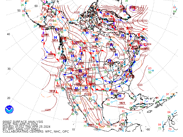
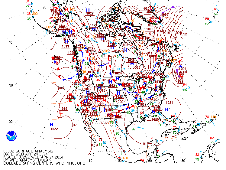
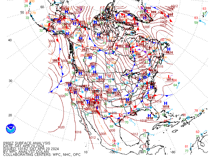
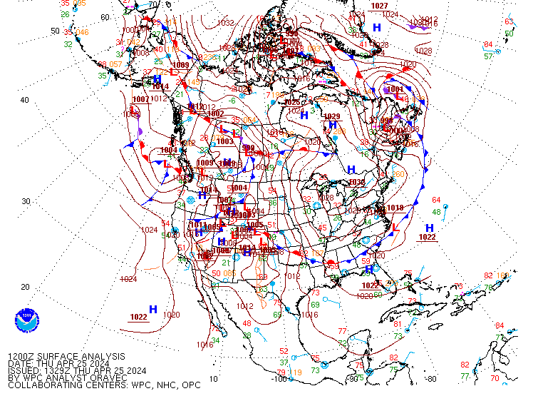
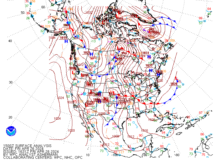
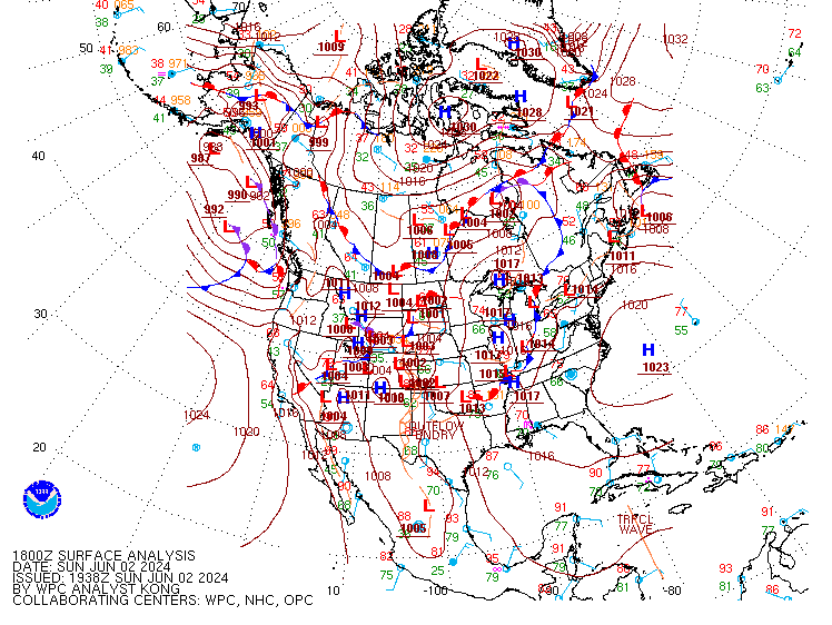
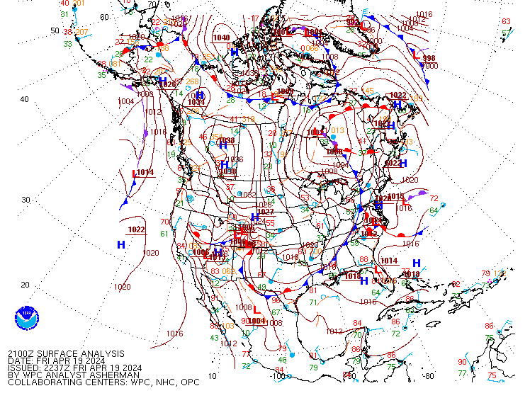
Surface Analysis ProductsThe following chart indicates the approximate issuance and web posting schedule for the WPC Surface Analysis. This product depicts the analysis of synoptic and sub-synoptic/mesoscale surface features including highs, lows, fronts, troughs, outflow boundaries, squall lines, and drylines. The analysis domain covers most of North America, the Western Atlantic and Eastern Pacific oceans, and the Gulf of Mexico.
PLEASE NOTE: The Pacific Ocean analyses (East and West Pacific) are prepared by NCEP's Ocean Prediction Center. |
Probabilistic Heavy Snow/Icing Forecasts
|
Short Range Forecasts
The short range meteorologist prepares 6 through 60 hour forecasts for the continental U.S., southern Canada, and northern Mexico. These products are issued twice daily using numerical model output from the National Weather Service's (NWS) Global Forecast System (GFS) and North American Mesoscale model (NAM), as well as guidance from the European Centre for Medium-Range Weather Forecasts (ECMWF), the United Kingdom's Meteorology Office (UKMET), the Meteorological Service of Canada, including ensembles. Coordination with the surface analysis, model diagnostics, quantitative precipitation, winter weather, and tropical forecast desks is also performed during the forecast process. The short range forecast products include surface pressure patterns (isobars), circulation centers and fronts for 6-60 hours, and a depiction of the types and extent of precipitation that are forecast at the valid time of the chart. The primary goal is to depict accurately the evolution of major weather systems that will affect the continental U.S. during the next 60 hours. In addition, discussions are written on each shift and issued with the forecast packages that highlight the meteorological reasoning behind the forecasts and significant weather across the continental United States. Please note that at this time isobars are not included on the 6-hour forecast and precipitation is not included on the 60-hour forecast chart. |
International DesksPlease click here to find out more about this WPC function. |
Storm summaries are issued for significant large-scale storms which: