| WPC Met Watch |
|
|
Mesoscale Precipitation Discussion: #0007 (2024) |
|
(Issued at 236 PM EST Tue Jan 09 2024
) |
|
| MPD Selection |
|
|
|
|
|

Mesoscale Precipitation Discussion 0007
NWS Weather Prediction Center College Park MD
236 PM EST Tue Jan 09 2024

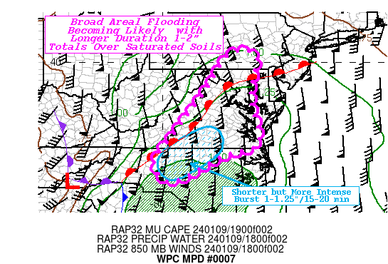
Areas affected...Central MD...Central VA...North-central NC...DC

Concerning...Heavy rainfall...Flash flooding likely

Valid 091935Z - 100135Z

SUMMARY...Prolonged moderate rain with some quick moving
convective line further south, crossing saturated grounds likely
to induce flooding conditions through the evening/early overnight
period.

DISCUSSION...19z surface analysis and VWP network sfc to 925mb
flow show warm front is starting to surge northeast under strong
low level southeasterly flow transporting enhanced moisture from
the western Atlantic feeder off the Sargasso Sea.  CIRA LPW depict
a sharp gradient in the lowest level in the vicinity of the the
NC/SC line and generally where higher higher theta-E air and weak
mid-level instability to help maintain quick moving convective
line across currently from Rockingham to York/Union county NC.
Combined with quick veering at the effective cold front, allows
for total moisture flux into the column enough to support 1.5"
totals in sub-hourly time frames (generaly 1"/15-20 minutes).
This line of enhanced convection is starting to move into areas
with reduced upper level soil capacity and lower FFG values across
north-central NC into southern VA.  As such, greater than normal
runoff is likely to induce flooding, perhaps flashy initially
before leading to a broader areal flooding that will impact more
surrounding smaller/combining watersheds across the region,
especially in urban locales.

Further north, CIRA LPW values are reduced, but slug of 700-500mb
mid-level moisture and favorable mid to upper-level
divergence/diffluence should support moderate rainfall.  Here,
duration is going will be more likely to result in inducing broad
areal flooding conditions across central to northern VA, central
MD into south-central PA.  Here, hourly FFG values are below 1"
and are about .5"/hr in urban centers (which is likely to be
exceeded as the main mid to upper-level height falls cross the
area from WSW to ENE from 23-01z.  Spotty totals of 1-2" are less
likely to exceed 3hr FFG values, but still should be broad enough
in exceedance to have solid confidence for likely flooding
conditions this evening.

Gallina

ATTN...WFO...AKQ...CTP...LWX...RAH...RNK...

ATTN...RFC...MARFC...SERFC...NWC...

LAT...LON   40447651 40047618 39577635 38917646 38437648
            37247617 36647630 36327751 35237958 36038031
            37057958 38537849 39037816 40277736
Download in GIS format: Shapefile
| KML
Last Updated: 236 PM EST Tue Jan 09 2024
|


