| WPC Met Watch |
|
|
Mesoscale Precipitation Discussion: #0040 (2019) |
|
(Issued at 1051 AM EST Mon Feb 11 2019
) |
|
| MPD Selection |
|
|
|
|
|

Mesoscale Precipitation Discussion 0040...Corrected
NWS Weather Prediction Center College Park MD
1051 AM EST Mon Feb 11 2019

Corrected for typo in last paragraph

Areas affected...central/northern AR, southeastern MO, western KY,
western TN

Concerning...Heavy rainfall...Flash flooding possible

Valid 111544Z - 112030Z

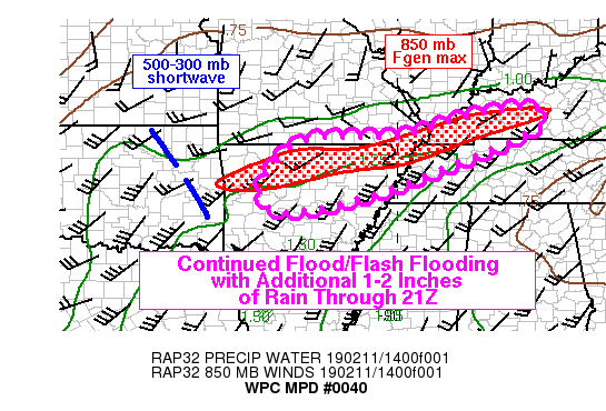
Summary...Steady rain with embedded rates peaking above 0.5 in/hr
will continue to affect portions of Arkansas through about 20Z,
followed by a temporary lull. Lower rates east of the Mississippi
River on top of saturated soils will continue to pose a flood
threat. Given saturated soils, continued flooding and flash
flooding are expected.

Discussion...Recent regional radar imagery through 15Z showed a
southwest to northeast oriented axis of moderate to heavy rain
extending from just north of Little Rock into far western KY with
observed peak rain rates near 0.5 in/hr. Recent development of
showers with embedded heavy rain cores were observed over western
and central AR ahead of a mid-upper level shortwave observed via
GOES-16 water vapor imagery over eastern OK. The southwest to
northeast axis of heavy rain was connected to a strong low level
frontogenesis max centered near 850 mb along with strong low level
convergence aligned from northern AR into western KY.

As the shortwave over eastern OK continues to advance toward the
northeast through 21Z, the low level frontogenesis max should
slowly lift north along with gradual weakening through 21Z as low
level wind fields to its north over southern MO/IL become
southerly. Given a lack of current and forecast MUCAPE values
above 250 J/kg over the area of interest and no appreciable change
in precipitable water values, rainfall rates should not peak much
higher than what has already occurred over the past few hours (0.5
to 1.0 in/hr). Additional rainfall of 1-2 inches can be expected
over the next few hours on top of already saturated soils given
1-3 inches of rain over the past 24 hours. Continued flooding is
likely and localized flash flooding given the longer duration and
relatively low rainfall rates of the event.

Otto

ATTN...WFO...LMK...LZK...MEG...OHX...PAH...SGF...

ATTN...RFC...ABRFC...LMRFC...OHRFC...

LAT...LON   37438654 36958645 35898890 35089113 34809305
            35429349 36409274 36659191 36708988 37198821
Last Updated: 1051 AM EST Mon Feb 11 2019
|


