| WPC Met Watch |
|
|
Mesoscale Precipitation Discussion: #0042 (2019) |
|
(Issued at 657 PM EST Mon Feb 11 2019
) |
|
| MPD Selection |
|
|
|
|
|

Mesoscale Precipitation Discussion 0042
NWS Weather Prediction Center College Park MD
657 PM EST Mon Feb 11 2019

Areas affected...Northwest OR

Concerning...Heavy rainfall

Valid 112356Z - 120956Z

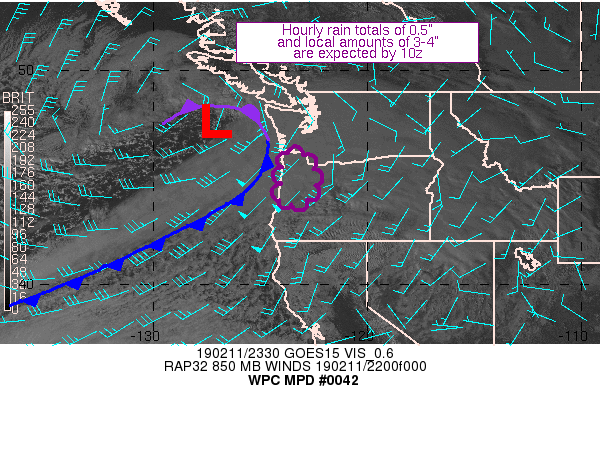
Summary...An low pressure area is expected to drop a cold front
slowly through western OR.  Hourly totals of 0.5" and local
amounts of 3-4" are expected by 10z.

Discussion...Infrared imagery reveals a low pressure area west of
WA with an elongated lobe of vorticity/possible secondary cold
front extending southwest towards 43N 139W.  Inflow at 850 hPa is
35-50 knots out of the southwest ahead of this system per recent
VAD wind profiles near the WA/OR coast.  Precipitable water values
have increased to close to 0.6" per recent GPS data.  SPC
mesoanalyses show a growing area of 100-300 J/kg MU CAPE area near
and offshore the OR coast.  Recent hourly precipitation totals in
northwest OR have risen to 0.3-0.45" near the coastal range per
the NWS Weather & Hazards Data Viewer.

As the system approaches the area, its cold front is expected to
intersect northwestern OR around 02z and slowly shift down the
coast.  Frontogenesis fields at 850, 750, and 650 hPa show a bit
of overlap near and after frontal passage which should aid
precipitation efficiency.  Other pluses for heavy rainfall include
850 hPa inflow rising to 65 knots and the expectation for MU CAPE
to linger across the area.  The combination of the above builds a
strong case of 0.5" an hour totals, and the mesoscale guidance
agrees that this is most likely to happen after 03z, with local
amounts of 3-4" expected by 10z.  Heavy rain related issues are
expected to be at lower elevations as snow levels are expected to
be low, in the 2000-3000 foot range.

Roth

ATTN...WFO...MFR...PQR...

ATTN...RFC...NWRFC...

LAT...LON   46202319 45722282 45182239 44532242 43992279
            43672380 43822409 45922392 46132370
Last Updated: 657 PM EST Mon Feb 11 2019
|


