| WPC Met Watch |
|
|
Mesoscale Precipitation Discussion: #0049 (2023) |
|
(Issued at 844 PM EST Tue Jan 24 2023
) |
|
| MPD Selection |
|
|
|
|
|

Mesoscale Precipitation Discussion 0049
NWS Weather Prediction Center College Park MD
844 PM EST Tue Jan 24 2023

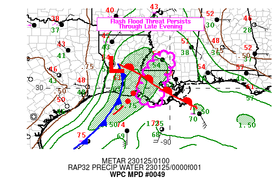
Areas affected...Portions of Louisiana and Southern Mississippi

Concerning...Heavy rainfall...Flash flooding possible

Valid 250143Z - 250430Z

SUMMARY...Possible isolated incidents of flash flooding continue
as surface low organizes and shifts east-northeast during the
evening and into the overnight.

DISCUSSION...RADAR Mosaic depicts strong thunderstorms along and
ahead of a cold front associated with an organizing area of
surface low pressure. Surface winds in the 20-25kt range with
~45-60 degrees of convergence of upper 60s to low 70s Tds,
combined with slowly veering 925-850mb moisture stream out of the
western Gulf across the low is supporting very strong ascent and
moisture flux to support localized 1 to 2 inch per hour rainfall
rates.  Mid to upper level RAP analysis supported by GOES-E WV
depicts the nose of best difluence aloft at this weak inflection
upstream of the surface low, showing signs of outpacing the best
wave.  This should support a few more hours of this strong
convergence with similar rates across portions of Louisiana and
southern/southwestern Mississippi...at which point the
inflection/best dynamic ascent will shift north and east of the
surface wave and LLJ will veer narrowing the warm sector/onshore
flow.

This should result in highly localized high run-off, but may not
expand in a broad enough area to pose larger areal incidents in
neighboring watersheds for all but low-end and urban and small
stream type flash flooding.  This should further diminishing
between 03Z and 04Z over south-central and southeast Louisiana as
warm sector continues to narrow further with instability only
remaining as MUCAPE isentropically ascended though the veering
850mb LLJ.  The HRRR has been performing well over the last few
runs despite showing itself to be a bit on the slow side.

Bann

ATTN...WFO...JAN...LCH...LIX...

ATTN...RFC...LMRFC...NWC...

LAT...LON   31989016 31598982 30869025 30279039 29899057
            29549048 29249058 29049076 29199123 29359165
            29599177 30879132 31679076
Last Updated: 844 PM EST Tue Jan 24 2023
|


