| WPC Met Watch |
|
|
Mesoscale Precipitation Discussion: #0071 (2023) |
|
(Issued at 1020 AM EST Wed Feb 22 2023
) |
|
| MPD Selection |
|
|
|
|
|

Mesoscale Precipitation Discussion 0071
NWS Weather Prediction Center College Park MD
1020 AM EST Wed Feb 22 2023

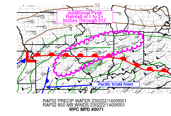
Areas affected...northeastern MO into central IL and northern IN

Concerning...Heavy rainfall...Flash flooding possible

Valid 221518Z - 222100Z

Summary...Increasing rain with embedded thunderstorms will likely
expand across portions of MO into IL and IN over the next few
hours. Short term training will have the potential to support
rainfall rates over 1 in/hr. Additional rainfall through 21Z
should generally be 1 to 2 inches, although localized 2+ inch
amounts cannot be ruled out along with localized flooding.

Discussion...15Z surface observations placed a warm front
extending from a low north of MCI, ESE across northern MO into the
OH Valley. Scattered convection has increased in coverage near and
north of the warm front across the Mississippi Valley into central
IL and western IN over the past 2 hours. The increase appears to
be a result of a combination of low level warm air advection,
ascent within the right entrance region of a 160-170 kt jet at 200
mb over the Upper Midwest and increasing lift out ahead of a
mid-level shortwave trough over the Southern Plains acquiring a
negative tilt. 12Z soundings from SGF and ILX showed precipitable
water values near 1.2 inches along with nearly 600 J/kg MUCAPE at
ILX.

While the zonally oriented upper level jet max over the Upper
Midwest will be exiting through the day, additional upper jet
support should arrive within the left exit region of an existing
130-140 kt speed max located over eastern OK, ahead of the
shortwave trough axis. In the low levels, a 50-60 kt 850 mb low
level jet will enhance moisture transport to the north with
precipitable water values forecast to increase to 1.5 inches
locally across the Midwest this afternoon. Mean southwesterly flow
will support axes of training heavy rain, combined with RAP
forecast MUCAPE values of 250-750 J/kg should allow for hourly
rainfall totals in excess of 1 inch, but likely no higher than 1.5
inches in an hour. Additional peak rainfall of 1 to 2 inches is
expected through 21Z, but localized totals over 2 inches will be
possible as well. Despite fairly dry antecedent conditions, flash
flood guidance (FFG) is as low as 1 in/hr in some areas of
northern IL/IN and 1 to 2 inches in 3 hours with a focus on
central to northern IL.

Otto

ATTN...WFO...DVN...EAX...ILX...IND...IWX...LOT...LSX...SGF...

ATTN...RFC...MBRFC...NCRFC...OHRFC...NWC...

LAT...LON   41558787 41548541 41108493 40558532 40288623
            39828770 39308918 38409081 37889216 38059274
            38579284 39689226 40858998
Last Updated: 1020 AM EST Wed Feb 22 2023
|


