| WPC Met Watch |
|
|
Mesoscale Precipitation Discussion: #0091 (2021) |
|
(Issued at 212 AM EDT Thu Apr 08 2021
) |
|
| MPD Selection |
|
|
|
|
|

Mesoscale Precipitation Discussion 0091
NWS Weather Prediction Center College Park MD
212 AM EDT Thu Apr 08 2021

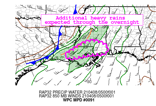
Areas affected...Southeastern LA...Southern MS

Concerning...Heavy rainfall...Flash flooding possible

Valid 080611Z - 081100Z

Summary...Heavy rainfall associated with a long-lived supercell is
expected to continue through the overnight hours.

Discussion...A long-lived supercell continues to move eastward
across southern Louisiana and southern Mississippi.  Convergent
low level inflow from the Gulf of Mexico continues to support a
moisture rich environment ahead of an approaching cold front, with
the latest mesoanalysis showing PWs of 1.5-1.7 inches extending
from southwestern Louisiana to central Mississippi.  Meanwhile,
MUCAPEs remain between 1000-2000 J/kg across much of the region.
Divergent flow south of a deep cyclone centered over the lower
Missouri Valley continues to support large-scale lift across the
region.   All of this has been supporting areas of heavy rainfall,
as shown by KPOE and KLIX radars -- which have indicated rainfall
rates of over 2 in/hr within some of the strongest cells.

As these cells continue to move east, heavy rainfall is expected
to remain a threat.  The latest RAP shows an increase in low level
moisture transport, with sustained 850mb winds of 30-40 kts across
southeastern Louisiana into southern Mississippi over the next
several hours.  While dropping off some, MUCAPEs are expected to
remain at or above 1000 J/kg within the highlighted area.  For the
remainder of the overnight period, the 00Z hi-res guidance, as
well as recent runs of the HRRR, suggest localized amounts of 2-3
inches are likely for portions of the highlighted area, with the
bulk of the heavy rainfall occurring within the next few hours.
Within the highlighted area, both the operational and parallel
versions of the HREF show high neighborhood probabilities (40km)
for rainfall amounts exceeding 2-inches between 6-12Z.  Given this
area has been dry in recent weeks, the threat for flash flooding
is considered low.  However, these rainfall rates may pose
localized runoff concerns, especially within urbanized areas.

Pereira

ATTN...WFO...JAN...LCH...LIX...MOB...

ATTN...RFC...LMRFC...NWC...

LAT...LON   31548997 31338892 30908838 30398854 30338934
            30249038 29929199 30219246 30629171 31129097
Last Updated: 212 AM EDT Thu Apr 08 2021
|


