| WPC Met Watch |
|
|
Mesoscale Precipitation Discussion: #0134 (2023) |
|
(Issued at 714 PM EDT Sun Mar 26 2023
) |
|
| MPD Selection |
|
|
|
|
|

Mesoscale Precipitation Discussion 0134
NWS Weather Prediction Center College Park MD
714 PM EDT Sun Mar 26 2023

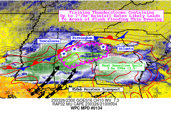
Areas affected...Central AL...West Central GA

Concerning...Heavy rainfall...Flash flooding likely

Valid 262310Z - 270500Z

SUMMARY...An approaching complex of storms, followed by potential
back building and training convection will likely result in areas
of flash flooding. Areas most prone to flash flooding are in
central AL and west-central GA where recent rounds of
thunderstorms have made soils more sensitive to heavy rainfall
rates.

DISCUSSION...A 500mb disturbance tracking into the Lower MS Valley
and the right-entrance region of a strengthening 250mb jet streak
are providing favorable vertical ascent aloft over much of the
South this afternoon. Convection has blossomed along two
boundaries; a front stretching from northern LA to the southern
Appalachians, and a surface trough located over southern AL and
southern GA. Southwesterly 850mb winds are steadily increasing
this afternoon and will become as strong as 45-50 knots between
02-05Z. This 850mb LLJ is responsible for the supply of rich 850mb
moisture flux oriented quasi-parallel to front and nearby surface
trough. In addition, 850-300mb mean flow and effective bulk shear
vectors are oriented parallel to the front. These are key
ingredients in establishing the potential for not only training
thunderstorms, but back-building thunderstorms so long as the
850mb flow continues to provide rich 850mb moisture and theta-e
advection into the front.

As the LLJ increases, so will PWs across the highlighted region to
as high as 1.75" this evening. In addition, MUCAPE heading into
the evening hours will approach or slightly surpass 2,000 J/kg,
giving ample instability to cells within the warm sector as well
as for elevated convection along the front. Effective bulk wind
shear is exceptional throughout the highlighted region with values
of 60-70 kts, along with effective SRH values forecast to reach
200-300 m2/s2 this evening. These values are critical to maintain
organized thunderstorms. Lastly, RH values in the 1000-500mb layer
will reach as high as 90% saturation and warm cloud layers as deep
as 10,000'. These storms will become more efficient rainfall
producers as the LLJ intensifies this evening and warm rain
processes become more favored.

The textbook synoptic and mesoscale drivers mentioned above are a
recipe for flash flooding. It is exacerbated by two other factors;
one of which is the swath of land from central AL to west-central
GA that received between 2-5" worth of rainfall within the past 12
hours. These locations, on average, contain <1.5" 1-hr FFGs with
some areas that received the highest amounts of rainfall featuring
<1" 1-hr FFGs. There is also the more urbanized corridor along
I-20 that includes the metro areas of Atlanta, Birmingham, and
Tuscaloosa, although the bulk of the most intense thunderstorm
activity may reside just to the south of I-20. Hourly rainfall
rates of up to 2"/hr are possible within the most intense areas of
convection. Rapid rises in nearby creeks and poor drainage areas
could occur, as well as flooded roadways that will be increasingly
more difficult to identify as the sun sets.

Mullinax

ATTN...WFO...BMX...FFC...

ATTN...RFC...SERFC...NWC...

LAT...LON   33908516 33878447 33708416 33128425 32508622
            32178722 32678756 33118801 33368762 33678672
            33858575
Last Updated: 714 PM EDT Sun Mar 26 2023
|


