| WPC Met Watch |
|
|
Mesoscale Precipitation Discussion: #0134 (2024) |
|
(Issued at 138 AM EDT Wed Apr 03 2024
) |
|
| MPD Selection |
|
|
|
|
|

Mesoscale Precipitation Discussion 0134
NWS Weather Prediction Center College Park MD
138 AM EDT Wed Apr 03 2024

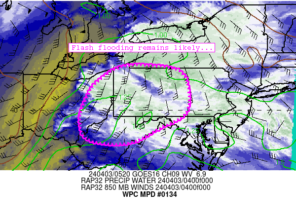
Areas affected...western/central Pennsylvania, portions of West
Virginia, western Maryland, and eastern Ohio

Concerning...Heavy rainfall...Flash flooding likely

Valid 030537Z - 031137Z

Summary...A persistent warm conveyor will continue to produce
areas of 0.25-0.75 inch/hr rain rates across the discussion area
through 12Z.  Flash flooding remains likely with this scenario.

Discussion...A warm/moist conveyor continues to result in
widespread precipitation across the discussion area - particularly
in western and central Pennsylvania.  This warm conveyor will
continue to foster low-level convergence and warm advection into
the discussion area due to continued deepening of a low over the
western Great Lakes.  Widespread areas of 0.25-0.75 inch/hr rain
rates continue, and are highest where MUCAPE is maximized across
West Virginia and Maryland.  Furthermore, the region has
experienced widespread 1-4 inch rainfall totals in the past 24
hours, resulting in wet ground conditions and low FFGs areawide
(as low as 0.25 inch/hr in spots).  As warm advection continues
across the region, it is not out of the question for rain rates to
exceed (perhaps double) 1-hour FFG thresholds at times, especially
where instability can redevelop due to cooling mid-level
temperatures from west to east over the next several hours.

The ongoing scenario for precipitation is not expected to change
substantially through 12Z, with periods of rainfall resulting in
another widespread 1-2 inches across the discussion area.  Flash
flooding remains likely.

Cook

ATTN...WFO...BUF...CLE...CTP...LWX...PBZ...RLX...

ATTN...RFC...MARFC...NERFC...OHRFC...NWC...

LAT...LON   42097844 41777730 40787697 39817718 39197830
            38467981 38638175 39638210 40618178 41278136
            42048019
Download in GIS format: Shapefile
| KML
Last Updated: 138 AM EDT Wed Apr 03 2024
|


