| WPC Met Watch |
|
|
Mesoscale Precipitation Discussion: #0152 |
|
(Issued at 1227 AM EDT Mon Apr 21 2025
) |
|
| MPD Selection |
|
|
|
|
|

Mesoscale Precipitation Discussion 0152
NWS Weather Prediction Center College Park MD
1227 AM EDT Mon Apr 21 2025

Areas affected...western Louisiana, southeastern Texas

Concerning...Heavy rainfall...Flash flooding possible

Valid 210426Z - 211026Z

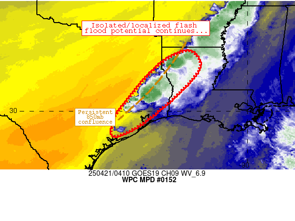
Summary...Isolated flash flood potential will continue through at
least 10Z/5a CDT.

Discussion...Flash flood potential continues across the region.
04Z radar mosaic imagery depicts scattered, slow moving clusters
of thunderstorms along an axis from just south of Shreveport to
just northwest of Houston.  The axis of convection was collocated
with an axis of confluent 850mb flow, with thunderstorms being
maintained by an airmass characterized by 1.5-1.8 inch PW values,
1000 J/kg MLCAPE, and weak convective inhibition.  Ascent aloft
associated with a mid-level wave continues to depart the region,
which has resulted in slower storm motions (from weaker wind
fields aloft) and occasional heavy rain rates lasting for 1-3
hours, resulting in local areas of 2-4 inch rainfall totals.
These totals have impacted portions of Shreveport Metro, prompting
impacts earlier tonight.

Models/observations suggest that the current trends will continue,
with areas of 2-5 inch rainfall totals occurring beneath heavier
and most persistent convection through 10Z this morning.  The
confluence axis and attendant thunderstorm activity may develop
slowly southward during this period as well.  FFGs are quite high
(~4 inch/3-hrly rates) across the region, suggesting that heavier
rainfall may need to occur across sensitive and/or urban ground
conditions for any substantial impacts to materialize.

Cook

ATTN...WFO...HGX...LCH...SHV...

ATTN...RFC...LMRFC...WGRFC...NWC...

LAT...LON   32819266 32029230 30659348 29299519 28829635
            29619631 30229592 31809459 32599358
Download in GIS format: Shapefile
| KML
Last Updated: 1227 AM EDT Mon Apr 21 2025
|


