| WPC Met Watch |
|
|
Mesoscale Precipitation Discussion: #0166 |
|
(Issued at 755 PM EDT Wed Apr 23 2025
) |
|
| MPD Selection |
|
|
|
|
|

Mesoscale Precipitation Discussion 0166
NWS Weather Prediction Center College Park MD
755 PM EDT Wed Apr 23 2025

Areas affected...in and near portions of western & northern MS

Concerning...Heavy rainfall...Flash flooding possible

Valid 232354Z - 240454Z

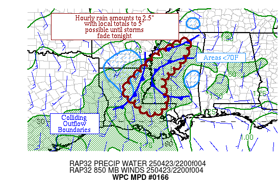
Summary...Thunderstorms with some level of organization should
persist in and near portions of western and northern MS in the
short term.  Hourly rain amounts up to 2.5" with local amounts to
5" are possible until thunderstorms fade this evening/tonight.

Discussion...The mesoscale pattern in and near MS is chaotic, with
a grand boundary collision coming shortly as the outflow
boundaries from the cold pools near the LA/AR border, southwest
TN, and eastern MS meet near the lower portion of the MS River
Valley.  Upstream, a strong shortwave is moving by the ArkLaTex,
eastward into the region enhancing upper level divergence.
Precipitable water values are 1.25-1.5".  ML CAPE is 1000-2000
J/kg, but CIN has set in near the LA/AR border and the central
MS/AL border where temperatures have fallen below 70F.  Effective
bulk shear is around 25 kts, allowing some storms to attain some
level of organization, but there are a lot of cell mergers
apparent in recent radar imagery.  Recent hourly rain amounts have
been up to 2.5" in several spots near the MS/LA border as well as
near Tchula MS.

While there are some location differences between the 18z HREF and
12z RRFS probabilities of 0.5"+ of rain in an hour, they point to
the region of highest instability between the various outflow
boundaries.  After 00z, there should be a slow waning in coverage
of the heavy rainfall, due to both increasing CIN and decreasing
ML CAPE in and near western and northern MS after all the outflow
boundaries collide and the atmosphere stabilizes.  Until then,
hourly rain amounts to 2.5" with local totals to 5" remain
possible, which could exceed flash flood guidance values and be
most problematic in urban areas.

Roth

ATTN...WFO...JAN...LCH...LIX...MEG...SHV...

ATTN...RFC...LMRFC...NWC...

LAT...LON   34578912 33718927 33168965 32479048 31869051
            30869034 30469124 31049186 31679261 32299220
            33079141 33509102
Download in GIS format: Shapefile
| KML
Last Updated: 755 PM EDT Wed Apr 23 2025
|


