| WPC Met Watch |
|
|
Mesoscale Precipitation Discussion: #0181 (2023) |
|
(Issued at 1112 PM EDT Wed Apr 12 2023
) |
|
| MPD Selection |
|
|
|
|
|

Mesoscale Precipitation Discussion 0181
NWS Weather Prediction Center College Park MD
1112 PM EDT Wed Apr 12 2023

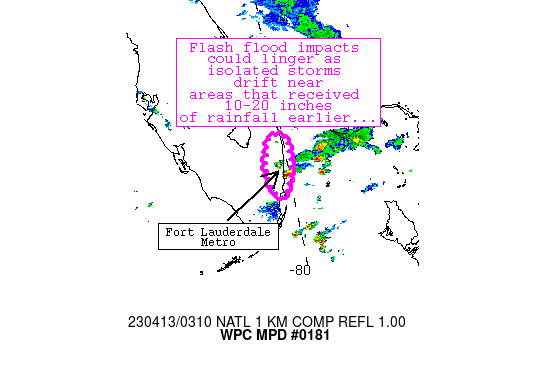
Areas affected...southeastern Florida/Fort Lauderdale area

Concerning...Heavy rainfall...Flash flooding possible

Valid 130311Z - 130600Z

Summary...Lingering convective activity could exacerbate ongoing
flash flood issues in the discussion area through 06Z or so.

Discussion...Recent convective trends indicate a distinct downtick
in convective intensity from a nearly stationary cluster of cells
that earlier produced 10-20 inches of rainfall near Fort
Lauderdale.  Lightning activity has decreased and inland
convection has drifted westward, resulting in a brief break in
rainfall for most areas.  However, another cell has developed over
adjacent waters about 5-10 miles southeast of FLL and is
maintaining a very weak mesocyclone while producing spots of 2-3.5
inch/hr rain rates.  Per objective analyses, low-level convergence
was greatest near a surface warm front that continues to extend
east-to-west across the general vicinity.  The convergence along
the front, combined with 1.7+ PW values and around 2000 J/kg
SBCAPE (highest over water) will continue to support occasional,
isolated convection for the next few hours.  A conditional risk of
inland development of this convection exists, which could
exacerbate issues with already inundated areas of the Fort
Lauderdale Metro.  Should another cell migrate into the area,
another 1-2 inches of rainfall could fall in a short period of
time.

Cook

ATTN...WFO...MFL...

ATTN...RFC...SERFC...NWC...

LAT...LON   26808008 26677992 26517992 26087996 25658020
            25928041 26328043 26728028
Last Updated: 1112 PM EDT Wed Apr 12 2023
|


