| WPC Met Watch |
|
|
Mesoscale Precipitation Discussion: #0183 (2023) |
|
(Issued at 104 PM EDT Thu Apr 13 2023
) |
|
| MPD Selection |
|
|
|
|
|

Mesoscale Precipitation Discussion 0183
NWS Weather Prediction Center College Park MD
104 PM EDT Thu Apr 13 2023

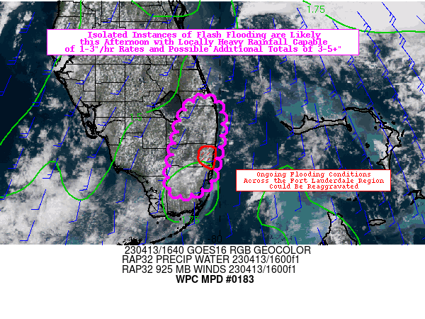
Areas affected...Southeastern Florida

Concerning...Heavy rainfall...Flash flooding likely

Valid 131700Z - 132300Z

Summary...Isolated instances of flash flooding are likely this
afternoon with locally heavy rainfall capable of 1-3"/hr rates.
This may lead to additional localized rainfall totals of 3-5+
inches, which could possibly aggravate ongoing flooding conditions
across the highly sensitive Fort Lauderdale region.

Discussion...Convection is beginning to percolate across
southeastern portions of the Florida Peninsula, and convective
initiation is expected to occur over the next several hours with
increasing solar insolation (with much less cloud cover today) and
mesoscale convergence/forcing provided from the sea breeze.
Concerns for flooding are certainly elevated today, given the
locally historic flash flood event that occurred across the Fort
Lauderdale area yesterday (with incredible localized 24-hour
rainfall totals of 18 to 26 inches observed). Across the broader
region of southeast Florida, rainfall totals largely ranged from
3-10 inches over the past 3 days, so antecedent conditions remain
sensitive across the Gold Coast (even well outside of the extreme
double digit totals from yesterday). While the environment will
not be nearly as supportive of very slow moving, organized
convection today, there is still an opportunity for locally high
rainfall totals of 3-5+ inches (as indicated by 12z HREF 40-km
neighborhood probabilities for 3" and 5" exceedance as high as 50%
and 10%, respectively).

From an ingredients-based perspective, today actually looks just
as favorable for locally heavy rainfall as yesterday. The
mesoscale environment is characterized by precipitable water
values of 1.6-1.8 inches (at or above the 90th percentile, per MFL
sounding climatology), ample instability with SB CAPE of 2500-3500
J/kg, and effective bulk shear of 30-40 kts. While these variables
should certainly support the organization of deep convection,
there are significant differences from yesterday that should limit
the prolonged occurrence of very heavy (2-3"+) rainfall rates.
These limiting factors include: 1) weaker low-level flow that has
veered significantly to the south, providing less coastal
convergence and much lower levels of moisture transport, and 2)
more unidirectional tropospheric flow that is less supportive of
organized supercells in-particular (with straighter hodographs and
bunkers right moving vectors that support the easterly progression
of discrete convection, should it develop). While these limiting
factors should almost certainly prevent any repeats of extreme
double digit totals, the 12z HREF (and subsequent HRRR runs) have
been in rather good agreement in depicting convective development
in the vicinity of the Gold Coast this afternoon (with HREF EAS -
ensemble scale agreement - 10-100 km neighborhood probabilities
indicating a 10-15% bullseye for 1" exceedance over the region
through 00z). Individual HRRR runs since 09z consistently depict
the potential for localized 2-4" totals through 23z, while the
HREF probability-matched mean depicts similar localized totals as
well (most prominently located in the vicinity of Fort
Lauderdale). Given the highly vulnerable antecedent conditions and
overall favorable environment for convective development and heavy
rainfall, localized instances of flash flooding are considered
likely (with the aggravation of flooding conditions possible in
the Fort Lauderdale region).

Churchill

ATTN...WFO...MFL...MLB...

ATTN...RFC...SERFC...NWC...

LAT...LON   27088016 26837997 26397999 26098004 25678018
            25498051 25568080 25848082 26128077 26358073
            26558068 26808061 27018044
Last Updated: 104 PM EDT Thu Apr 13 2023
|


