| WPC Met Watch |
|
|
Mesoscale Precipitation Discussion: #0219 (2023) |
|
(Issued at 420 PM EDT Sun Apr 30 2023
) |
|
| MPD Selection |
|
|
|
|
|

Mesoscale Precipitation Discussion 0219
NWS Weather Prediction Center College Park MD
420 PM EDT Sun Apr 30 2023

Areas affected...northern half of NJ & southeastern mainland NY

Concerning...Heavy rainfall...Flash flooding possible

Valid 302019Z - 010219Z

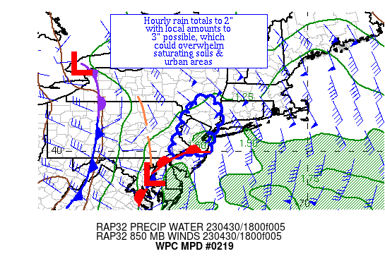
Summary...A couple rounds of convection are expected to lead to
heavy rains across northern NJ and southeastern NY.  Hourly rain
totals to 2" with local amounts to 3" are possible, which could
lead to flash flooding.

Discussion...A couple rounds of thunderstorms -- one moving across
southern NJ and another in southeast VA -- are moving towards the
region from the south-southwest.  MU CAPE is 500+ J/kg across
southern NJ, associated with the northward movement of a coastal
warm front to the north of a low pressure system over Chesapeake
Bay.  Divergence aloft is increasing as an upper low/trough across
NC takes on a negative tilt.  Precipitable water values are
1.15-1.3" and rising per GPS data.  Effective bulk shear of 30-40
knots is being mainly driven by southerly flow of 35 kts at 850
hPa (per VAD wind profiles) overriding east 10-15 knots of surface
wind.

RAP guidance suggests that 500-1000 J/kg of MU CAPE should move as
far poleward as southeast NY as the surface low moves generally up
the Fall Line and Delaware River Valley with time.  This should
allow a couple rounds of convection to move into the region -- one
early and one late in the period.  As precipitable water values
rise towards 1.5" this evening, hourly rain totals could reach 2"
should any thunderstorms train, evolve into mesocyclones, or merge
which would overwhelm the low flash flood guidance values in and
near central and northern NJ and possibly broach them across
southeast mainland NY.  The mesoscale guidance suggests that 2"
should be the high bar for amounts, though local 3" amounts over
the next six hours can't be ruled out, which would be most
problematic over saturating soils and urban areas.  There are
expected to be a mix of short and long duration heavy rain issues
during the MPD period, with any flash flooding occurrences
expected to be isolated to widely scattered.

Roth

ATTN...WFO...ALY...BGM...OKX...PHI...

ATTN...RFC...MARFC...NERFC...NWC...

LAT...LON   42197408 41627361 41077365 40817396 40507401
            40217397 39907409 40127458 39877549 40667515
            41047503 41597480
Last Updated: 420 PM EDT Sun Apr 30 2023
|


