| WPC Met Watch |
|
|
Mesoscale Precipitation Discussion: #0235 (2020) |
|
(Issued at 100 AM EDT Sat May 23 2020
) |
|
| MPD Selection |
|
|
|
|
|

Mesoscale Precipitation Discussion 0235...Corrected
NWS Weather Prediction Center College Park MD
100 AM EDT Sat May 23 2020

Corrected to say FLASH FLOODING LIKELY

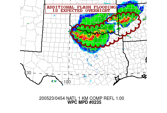
Areas affected...Northern TX...Southern OK...West-Central AR

Concerning...Heavy rainfall...Flash flooding likely

Valid 230455Z - 230930Z

SUMMARY...Training and locally backbuilding showers and
thunderstorms will continue across areas of northern TX and
potentially far southern OK, with a separate focus across areas of
west-central AR. Additional areas of flash flooding are likely.

DISCUSSION...The latest radar imagery shows a band of very heavy
showers and thunderstorms focusing across portions of far northern
TX and adjacent areas of the Red River Valley, with a separate
band of convection seen developing over eastern OK and also
crossing through west-central AR.

The activity is focusing near the nose of a 30 to 40 kt
south-southwest low-level jet and with a very unstable airmass
pooled across the region with MLCAPE values of 3000 to 4000 j/kg
pooled over northern TX, and 2000 to 3000 j/kg over eastern OK and
west-central AR. The latest satellite imagery is showing some
additional expansion of cooling convective tops and indicative of
the larger scale convective evolution continuing to mature.

Very heavy rainfall totals have already occurred along the OK/TX
and especially over Clay County and Montague County of far north
Texas with the aid of 2 to 3 inch/hr rainfall rates. The latest
MRMS max unit streamflow FLASH data is suggesting severe
runoff/flash flooding ongoing over these areas, and especially
with multiple hours worth of backbuilding and training convective
cells that have already occurred.

The latest HRRR and experimental WoF model guidance from 03Z show
a likelihood of additional heavy rainfall with additional totals
going through 09Z of 4 to 6 inches with locally heavier amounts
for areas of far northern TX given the slow cell motions and
set-up for training. Gradually this convection should generate
enough of a surface-based cold pool for the convection to
accelerate southeastward, but that will not occur until later in
the night, so for the next few hours, expect additional areas of
flash flooding over northern TX in particular.

For areas of eastern OK and west-central AR, the convection here
should not be quite as organized, but it will be slow-moving, and
still taking advantage of a very unstable and moist airmass. The
HRRR and experimental WoF guidance suggest as much as an
additional 2 to 4 inches of rain here and especially over
west-central AR. So, the threat for areas of flash flooding will
continue here as well.

Orrison

ATTN...WFO...FWD...LZK...OUN...SHV...SJT...TSA...

ATTN...RFC...ABRFC...LMRFC...WGRFC...NWC...

LAT...LON   35549381 35459254 34919218 34359241 33739400
            33249486 32789618 32809779 33059866 33639952
            34009968 34389947 34479883 34369776 34609625
            35249519
Last Updated: 100 AM EDT Sat May 23 2020
|


