| WPC Met Watch |
|
|
Mesoscale Precipitation Discussion: #0270 |
|
(Issued at 429 PM EDT Wed May 14 2025
) |
|
| MPD Selection |
|
|
|
|
|

Mesoscale Precipitation Discussion 0270
NWS Weather Prediction Center College Park MD
429 PM EDT Wed May 14 2025

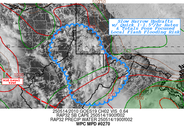
Areas affected...Northern WV...Southwest PA...Adj Eastern OH...
Far Western MD...Far Northwest VA...

Concerning...Heavy rainfall...Flash flooding possible

Valid 142030Z - 150100Z

SUMMARY...Slow moving, scattered to regionally dense narrow core
convective cells capable of 1-1.5"/hr rates/totals over complex
and recently saturated soils pose localized/focused flash flooding
potential through evening.

DISCUSSION...Recent GOES-E Visible loop shows broad area of
congested cu/Tcu across northern WV into far SW PA/Garrett county
MD become more numerous and increasing in vertical depth.  Area
has been confined to the north and northeast given prolonged
stratus deck limiting peak heating.  Surface Tds in the upper
50s/low 60s remains well above normal and with modest mid-level
lapse rates, SBCAPEs have risen to 1500 J/kg to help
develop/maintain convective vigor for the next few hours.   GOES-E
WV loop and RAP analysis denotes decaying upper-level low has
sheared from NW to SE with core of vorticity across the Piedmont
of NC/S VA with a secondary lobe back toward N OH, this has
resulted in broad northeastward lift of the trof, but also
resulted in slowing of the mid-level steering to less than
15-20kts. This should allow for strong cells to develop and
collapse within a 1-2 hour period with locally intense rain-rates
up to 1-1.5".

While localized, the overall density of the narrow cores is fairly
close in proximity, that as new development produces outflow and
seeks out remaining unstable parcels for additional development,
proximity may allow for isolated spots to have a second intense
pulse with overall spotty totals perhaps reaching 2", with highest
probability over NE WV into SW PA, as further north remains more
stable given the lack of heating this afternoon.  Given these
intense rates over complex terrain naturally with lower FFG;
recent heavy rainfall in spots over the last day or so as further
reduced the capacity of soils, with increased run-off likely.  As
such, scattered incidents of flash flooding are considered
possible through late evening/early overnight as instability is
exhausted.

Gallina

ATTN...WFO...LWX...PBZ...RLX...RNK...

ATTN...RFC...MARFC...OHRFC...NWC...

LAT...LON   40788042 40427977 39717944 39077858 37977931
            37978049 38858081 39368114 39778148 40568117
Download in GIS format: Shapefile
| KML
Last Updated: 429 PM EDT Wed May 14 2025
|


