| WPC Met Watch |
|
|
Mesoscale Precipitation Discussion: #0277 |
|
(Issued at 1123 AM EDT Fri May 16 2025
) |
|
| MPD Selection |
|
|
|
|
|

Mesoscale Precipitation Discussion 0277
NWS Weather Prediction Center College Park MD
1123 AM EDT Fri May 16 2025

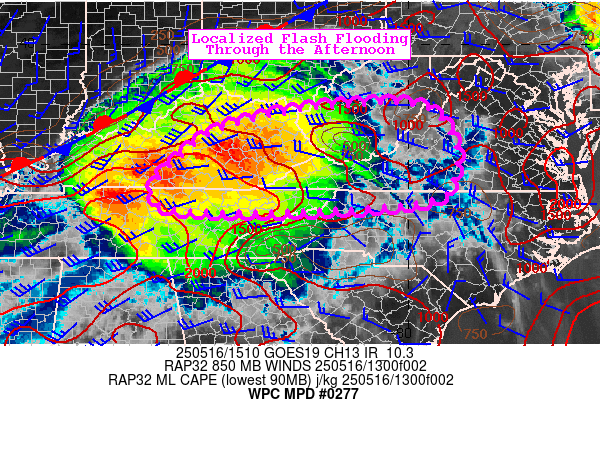
Areas affected...South-Central Appalachians

Concerning...Heavy rainfall...Flash flooding possible

Valid 161519Z - 162015Z

Summary...Risk of repeating heavy thunderstorms across the
south-central Appalachians  this afternoon. Fast motion to these
storms will continue, so flash flooding is possible where cell
mergers and repeating of the heaviest activity occurs.

Discussion...Numerous supercells embedded in a quasi-linear system
east of a stationary front will continue to develop and shift east
over the south-central Appalachians this afternoon. Gulf-sourced
moisture (PW of 1.7 to 1.9") is pooling ahead of the front with
higher instability MLCAPE 1500 to 2500 J/kg) and powerful deep
layer WSWly flow (50 to 60kt) allowing for heavy repeating cells.
Peak hourly rainfall estimates of 1.0 to 1.5" per hour continue in
the heaviest cells which also have hail present. The RRFS
continues to have a decent handle on this regional activity
especially compared to recent HRRRs which are too late with
activity. The 13Z RRFS indicates potential for 3" over the next
few hours which is reasonable given the repeating threat from flow
parallel to the front.

Flash flood guidance decreases east from KY with terrain with
three-hour values of 1.5 to 2" decreasing to as low as 1". Given
the axis of higher instability continuing through the crest of the
Appalachians, there is a notable threat for flash flooding in
spite of the fast cell motion.


Jackson

ATTN...WFO...JKL...LMK...LWX...MRX...OHX...RLX...RNK...

ATTN...RFC...LMRFC...MARFC...OHRFC...SERFC...NWC...

LAT...LON   38588107 38537968 37937903 37107891 36287983
            36208569 37638499 38308328
Download in GIS format: Shapefile
| KML
Last Updated: 1123 AM EDT Fri May 16 2025
|


