| WPC Met Watch |
|
|
Mesoscale Precipitation Discussion: #0307 |
|
(Issued at 254 AM EDT Sat May 24 2025
) |
|
| MPD Selection |
|
|
|
|
|

Mesoscale Precipitation Discussion 0307...Corrected
NWS Weather Prediction Center College Park MD
254 AM EDT Sat May 24 2025

Corrected for graphic text and hatched area

Areas affected...central through southeast Kansas, northeastern
Oklahoma, southwestern Missouri, northern Arkansas

Concerning...Heavy rainfall...Flash flooding likely

Valid 240642Z - 241242Z

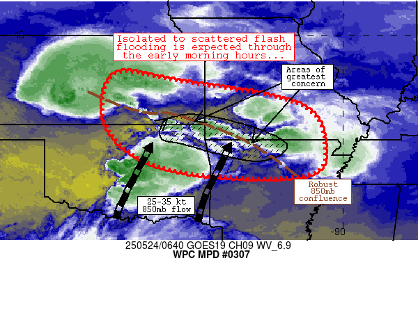
Summary...Several rounds of thunderstorms should result in
isolated to scattered flash flooding through 12-13z (7-8a CDT)
this morning across the discussion area.  Areas of 3-5 inch totals
are expected, with heaviest totals from far northeast Oklahoma
into southern Missouri and northern Arkansas.

Discussion...Latest radar mosaic imagery depicts scattered
convection with increasing coverage from southwest Kansas eastward
to along the Missouri/Arkansas border near Flippin, AR.  The
storms are oriented parallel to west-northwesterly steering flow
aloft while also focused on the nose of a broad 25-35 knot 850mb
jet axis across Oklahoma. Steep mid-level lapse rates and strong
shear aloft was enabling strong updrafts, while the orientation of
low-level convergence was supporting training/repeating of cells
especially across southern Missouri, where current estimates of
2-4 inch rainfall totals were noted in a few areas over the past 6
hours.

The ongoing scenario favors a continued expansion of convection
along the low-level convergence zone, with continued convective
training/repeating resulting in scattered instances of flash
flooding.  Perhaps the greatest risk of excessive runoff will
exist across far northeastern Oklahoma, southwestern Missouri, and
northern Arkansas, where 1) the greatest duration of persistent
deep convection will reside and 2) hilly/sensitive terrain exists,
supporting flooding.  Another 3-5 inches of rain is expected
generally along an axis from Joplin, MO to Flippin, AR, with
locally higher amounts possible.

Farther upstream (across central Kansas), convection is slightly
more progressive and FFGs slightly higher, suggestive of a more
isolated flash flood threat compared to downstream areas.

Cook

ATTN...WFO...EAX...ICT...LZK...MEG...OUN...PAH...SGF...TOP...
TSA...

ATTN...RFC...KRF...MSR...ORN...TUA...NWC...

LAT...LON   38709765 38479560 37669143 36099063 35319132
            35329453 35899682 37139798
Download in GIS format: Shapefile
| KML
Last Updated: 254 AM EDT Sat May 24 2025
|


