| WPC Met Watch |
|
|
Mesoscale Precipitation Discussion: #0314 (2023) |
|
(Issued at 936 AM EDT Fri May 19 2023
) |
|
| MPD Selection |
|
|
|
|
|

Mesoscale Precipitation Discussion 0314
NWS Weather Prediction Center College Park MD
936 AM EDT Fri May 19 2023

Areas affected...Southern North Carolina Coast...

Concerning...Heavy rainfall...Flash flooding likely

Valid 191335Z - 191815Z

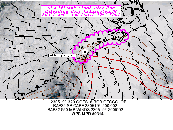
SUMMARY...Significant flash flooding ongoing, likely to continue
for a few more hours.  Further expansion up the coast possible,
but not as severe in magnitude.

DISCUSSION...Local observations in the western Wilmington suburbs
suggest rainfall rates/totals are underestimated from the KLTX
radar with numerous 7-9" totals in the last 3hrs.  A surface
boundary has been attached to the coast and very strong orthogonal
925-850mb unstable air has converged at Wilmington but slowly is
shifting northward up the coast.  Deep layer moisture flux
convergence values are as high as seen in landfalling tropical
systems supporting these 3+/hr rates.  A weak surface inflection
appears to have developed based on the winds, but the latent heat
release has developed an MCV that appears to be retrograding west
in the near term.  With its strength, flanking features are
starting to manifest with warm frontal and cold frontal bands
located across the northern suburbs of ILM and south toward Oak
Island.  Visible imagery denotes cumuliform/overshooting tops
still remain strong continueing maintenance of the MCV and
moisture flux convergence setup for the next 2+ hours.  As such,
an additional 3-6" (localized maxima up to 10-12") is possible in
the areas already affected, but further expansion north and
northeastward is becoming more likely increasing the areal
coverage for risk of rapid inundation flooding with 4-6" areal
coverage into southern Pender over the next few hours.

While gradient of instability is very stark toward Cape
Hatteras/Newport area, the deeper shortwave and inverted surface
inflection/convergence area is lifting north as well, the
sharpness of the inverted trough suggests a new focus will develop
further up the coast by early afternoon, with similar potential at
or very near the coastline itself. Heavy rain should not surge
onshore too far from instability source/tight gradient over the
near coastal waters.

Gallina

ATTN...WFO...ILM...MHX...

ATTN...RFC...SERFC...NWC...

LAT...LON   35007681 35007640 34897621 34567652 34607683
            34507728 34207768 33977781 33837791 33797805
            33867820 33987839 34307834 34677789 34927740
Last Updated: 936 AM EDT Fri May 19 2023
|


