| WPC Met Watch |
|
|
Mesoscale Precipitation Discussion: #0321 (2021) |
|
(Issued at 1219 PM EDT Thu Jun 10 2021
) |
|
| MPD Selection |
|
|
|
|
|

Mesoscale Precipitation Discussion 0321
NWS Weather Prediction Center College Park MD
1219 PM EDT Thu Jun 10 2021

Areas affected...portions of the northern Mid-Atlantic region

Concerning...Heavy rainfall...Flash flooding likely

Valid 101616Z - 102215Z

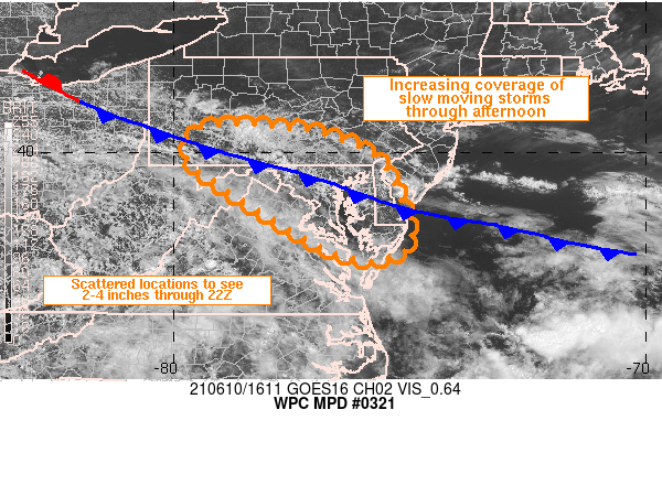
SUMMARY...Slow moving thunderstorms are expected to increase in
coverage across the northern Mid-Atlantic region this afternoon.
Rainfall rates of 1-2 in/hr will be common, but locally higher
rates can not be ruled out.

DISCUSSION...Visible satellite imagery through 1545Z showed an
expanding cumulus field within an otherwise mostly clear
environment across the Delmarva Peninsula into MD and southeastern
PA. A few showers and thunderstorms have also popped up on
regional radar imagery over northern Delaware Bay and  along the
Catocin Mountains of northern MD into the Appalachian chain of
southern PA. PWATs within the pre-convective environment are 1.7
to 2.0 inches and 850-200 mb mean-layer flow is very weak across
the entire region at less than 10 kt, which will support slow
storm motions. Little CIN on the 12Z soundings from WAL and IAD
suggest storm coverage will continue to increase with daytime
heating with the front and local terrain acting as sources for
lift. In addition, locally stronger easterly flow just behind the
cold front may help to support near-stationary convection along
the terrain of northern VA into northwestern MD and southern PA.

Given the lack of speed shear with height, storms should not be
organized in nature or long-lasting, but they should be rather
efficient with rainfall production given high wet bulb zero
heights of roughly 13 kft. Rainfall rates of 1-2 in/hr are very
likely with localized rainfall rates up to 3 in/hr possible. In
fact, rainfall rates from the HRRR support 1-2 inches of rain in
15 to 30 minutes which seems reasonable given the moist
environment. Portions of the Delmarva into southern MD and
southeastern PA received heavy rainfall yesterday and will be more
susceptible to localized flash flooding today. While flash
flooding is not expected to be widespread across the entire
region, scattered to numerous slow moving thunderstorms will
produce heavy rainfall with several areas at risk for flash
flooding, including the urban I-95 corridor from south of D.C.
into northern DE with 2-4 inches expected through 22Z.

Otto

ATTN...WFO...AKQ...CTP...LWX...PBZ...PHI...

ATTN...RFC...MARFC...OHRFC...NWC...

LAT...LON   40587854 40517767 40357679 40047594 39547543
            38187496 37767548 37877657 39167880 39907971
            40507942
Last Updated: 1219 PM EDT Thu Jun 10 2021
|


