| WPC Met Watch |
|
|
Mesoscale Precipitation Discussion: #0329 (2021) |
|
(Issued at 919 PM EDT Thu Jun 10 2021
) |
|
| MPD Selection |
|
|
|
|
|

Mesoscale Precipitation Discussion 0329
NWS Weather Prediction Center College Park MD
919 PM EDT Thu Jun 10 2021

Areas affected...West-Central Arkansas...

Concerning...Heavy rainfall...Flash flooding possible

Valid 110120Z - 110545Z

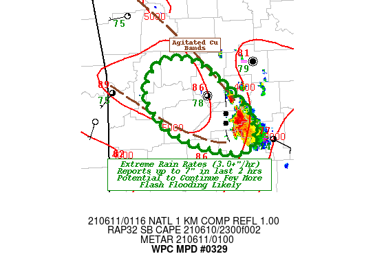
SUMMARY...Highly efficient cell building into the flow with deep
moisture/instability to maintain for a few more hours.

DISCUSSION...LZK RADAR denotes a lingering thunderstorm that
continually is regenerating along a slow westward propagating
outflow boundary.  00z meso-analsys denotes a narrow ribbon along
its westward path of enhanced low level moisture/temperature with
90F over 80F Tds SW of RUE and 90 over 76F at RUE proper.  Waning
Visible imagery shows two agitated cu band bounding this locally
higher unstable environment.

Backyard weather observations indicate multiple stations over 4"
(max 7.4") over the last two hours in the western suburbs/exurbs
of Little Rock/Pulaski county. OU Flash Unit Stream Flow
magnitudes over 800 cfs/mi suggest significant flash flooding is
likely ongoing.

Given flux convergence and amount of moisture, rain rates of
3.5"/hr are expected and with 10kts of westerly progression,
expect similar totals especially if enhanced by terrain through
the Ouachita mountains.  Flash flooding is likely to continue
until instability starts to wane a few hours after sunset (06z).

Gallina

ATTN...WFO...LZK...TSA...

ATTN...RFC...ABRFC...LMRFC...NWC...

LAT...LON   35639329 35319283 34979252 34659255 34629276
            34679309 34909362 35309390 35629371
Last Updated: 919 PM EDT Thu Jun 10 2021
|


