| WPC Met Watch |
|
|
Mesoscale Precipitation Discussion: #0330 (2021) |
|
(Issued at 1017 PM EDT Thu Jun 10 2021
) |
|
| MPD Selection |
|
|
|
|
|

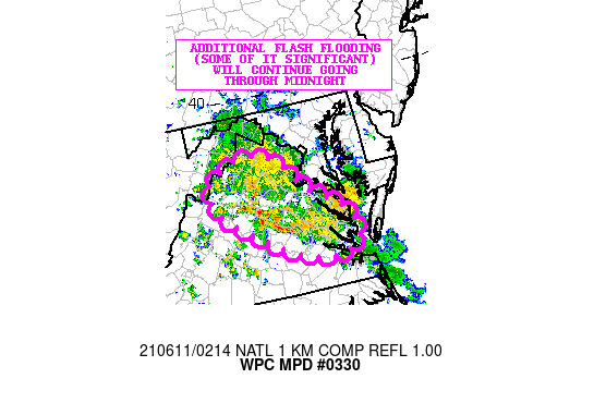
Mesoscale Precipitation Discussion 0330
NWS Weather Prediction Center College Park MD
1017 PM EDT Thu Jun 10 2021

Areas affected...Central and Northern VA

Concerning...Heavy rainfall...Flash flooding likely

Valid 110215Z - 110630Z

SUMMARY...Slow-moving and extremely efficient showers and
thunderstorms continue to impact areas of the Mid-Atlantic with an
emphasis on central and northern VA. Additional flash flooding
(some of it significant) is expected to continue going through
midnight.

DISCUSSION...The latest radar imagery continues to show the
development of slow-moving and extremely efficient showers and
thunderstorms as a cold front settles southward down through the
Mid-Atlantic region and interacts with a very moist and at least
modestly unstable airmass. As this has been occurring this
evening, there has been the slow eastward advance of a mid-level
shortwave impulse across central and northern VA which is yielding
at least some deeper layer ascent.

Rainfall rates have been extremely heavy over the last few hours,
with rates locally exceeding 4 inches/hr, and multiple areas in
and around the Culpeper area seeing as much as 8 inches of rain
over the last 3 to 4 hours. Extensive areas of flash flooding have
been occurring over this region.

Rainfall rates are expected to remain extremely high at least in
the short-term where convection remains more focused, and
especially given the pooling of moisture/instability, and axis of
stronger low-level convergence and mid-level forcing along the the
front. Additional areas of showers and thunderstorms have been
seen becoming concentrated south of Culpeper and closer into areas
near Charlottesville and also down into the Richmond metropolitan
area over the last hour. Thus, there will likely be an uptick in
flash flooding concerns across these areas going through the
midnight time frame.

Expect locally an additional 5+ inches of rain where the more
concentrated activity sets up going through 06Z. Thereafter, there
should be sufficient waning of the boundary layer instability to
allow the convection to weaken and with rain rates diminishing.

Orrison

ATTN...WFO...AKQ...LWX...RNK...

ATTN...RFC...MARFC...SERFC...NWC...

LAT...LON   38977846 38857769 38297716 37887646 37377619
            37057659 37117716 37337783 38057896 38617916
Last Updated: 1017 PM EDT Thu Jun 10 2021
|


