| WPC Met Watch |
|
|
Mesoscale Precipitation Discussion: #0332 |
|
(Issued at 555 PM EDT Thu May 29 2025
) |
|
| MPD Selection |
|
|
|
|
|

Mesoscale Precipitation Discussion 0332
NWS Weather Prediction Center College Park MD
555 PM EDT Thu May 29 2025

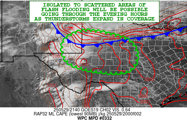
Areas affected...Southeast NM...Western and Central TX

Concerning...Heavy rainfall...Flash flooding possible

Valid 292155Z - 300355Z

SUMMARY...Clusters of showers and thunderstorms over southeast NM
and southwest TX will continue to generally expand in coverage
over the next few hours. A gradual increase in heavy rainfall
rates is expected as this activity organizes further this evening,
and this may result in isolated to scattered areas of flash
flooding.

DISCUSSION...The late-afternoon GOES-E visible satellite imagery
shows expanding convective clusters over southeast NM and
southwest TX as strong diurnal heating and corresponding boundary
layer instability work in tandem with relatively moist low-level
southeast flow and localized orographic ascent. All of this is
occurring south of a cold front dropping southward down across the
southern High Plains which will be an additional catalyst for
convective development over the next several hours.

MLCAPE values over much of central and western TX in particular
are quite elevated with values of 2000 to 3000+ J/kg, although the
latest RAP analysis does still show some pockets of MLCIN
extending north/south from the Midland vicinity down through Fort
Stockton. Any remaining CIN should gradually erode over the next
couple of hours as additional surface heating occurs, and this
will help set the stage for upstream convection consolidating over
southeast NM and southwest TX to then advance off to the east and
grow upscale into the very unstable/moist airmass pooled
downstream.

Aside from favorable thermodynamics, strong shear parameters are
yielding a number of supercell thunderstorms already, and this
threat will continue in the near-term as the activity consolidates
into a least a broken MCS by this evening. Increasing low-level
convergence along the front and also some nearby right-entrance
region upper jet support will also be key players in driving the
convective threat well through the evening hours for areas farther
east across western and central TX.

REFS/HREF suites of guidance show rather strong support for the
stronger storms to produce rainfall rates well into the 1 to 2
inch/hour range. A combination of slow cell-motions and
cell-merger activity in the early stages of this evening's MCS
development will support some rainfall totals reaching as high as
3 to 4 inches. Both the REFS and HREF suites show elevated 3-hour
FFG exceedance probabilities over portions of central and western
TX this evening, and thus given the setup, isolated to scattered
areas of flash flooding will be possible.

Orrison

ATTN...WFO...ABQ...FWD...LUB...MAF...SJT...

ATTN...RFC...FWR...NWC...

LAT...LON   33620275 33440119 32859949 31929899 31149913
            30639985 30650167 31080354 31690432 32660445
            33330383
Download in GIS format: Shapefile
| KML
Last Updated: 555 PM EDT Thu May 29 2025
|


