| WPC Met Watch |
|
|
Mesoscale Precipitation Discussion: #0341 (2023) |
|
(Issued at 213 AM EDT Fri May 26 2023
) |
|
| MPD Selection |
|
|
|
|
|

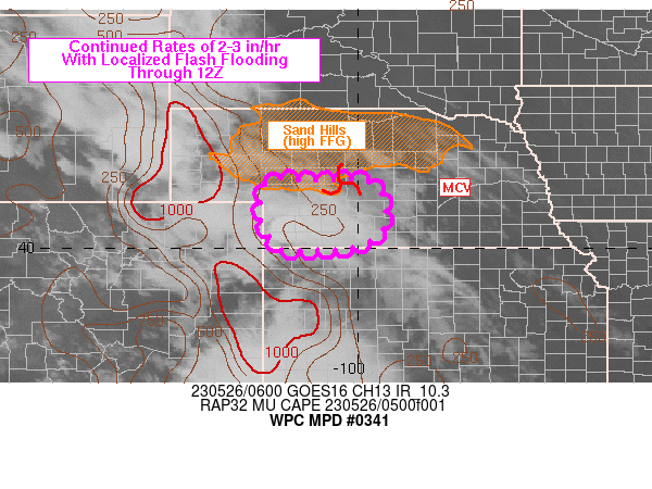
Mesoscale Precipitation Discussion 0341
NWS Weather Prediction Center College Park MD
213 AM EDT Fri May 26 2023

Areas affected...southwestern to south-central NE

Concerning...Heavy rainfall...Flash flooding possible

Valid 260610Z - 261210Z

SUMMARY...An isolated flash flood threat will persist across
portions of southwestern to south-central NE through 12Z. Rainfall
rates of 2-3 in/hr will be possible with slow moving and/or
training of cells.

DISCUSSION...0530Z reflectivity from KGLD continued to show a
small cluster of thunderstorms over southwestern NE, south of I-80
and west of Rt. 283. Slow moving cores of heavy rain (MRMS-derived
rates of 2-3 in/hr) contained within were relatively small,
focusing over Dundy and Red Willow counties but new updraft
development continues to occur across the region with new cells
noted in local radar imagery over the past 1-2 hours. Convective
development was occurring along the eastern edge of a weak axis of
MUCAPE that was estimated to be 250-750 J/kg via the 05Z and 06Z
SPC mesoanalysis. The complex of storms was located beneath an
upper level ridge axis with enhanced diffluence aloft. Low level
confluence was also noted at 700 mb between VAD wind plots at KLNX
and KGLD, located to the southwest of a remnant MCV located along
the Lincoln/Logan county line at 0530Z. Additional mesoscale
circulations were noted with the cells in Dundy and Red Willow
counties, supporting efficient rainfall production.

The MCV along the Lincoln/Logan county line is likely to continue
moving north but the environment to its southwest is not expected
to change much over the next few hours. Continued low level
confluence/upper level diffluence and lingering weak instability
are likely to support the maintenance of the thunderstorm cluster
over the next 4-6 hours. While some weakening of the 30 to 40+ kt
low level jet is possible by 12Z, weak deeper-layer mean flow
combined with the relatively strong low level flow will promote
south to north training and potential back-building of storms into
the inflow. Therefore, while coverage may remain isolated, a flash
flood threat will continue through the early morning hours over
southwestern/south-central NE.

Otto

ATTN...WFO...BOU...GID...GLD...LBF...

ATTN...RFC...MBRFC...NWC...

LAT...LON   41490160 41450091 41490012 41309955 40549940
            40179972 40010024 39970096 39990162 40460201
            41050207 41430192
Last Updated: 213 AM EDT Fri May 26 2023
|


